🔄 Updated 21 Jun 2026
Before we dive in, let's clear up the names. A lot of people search for "Pha Daeng" or "Pha Iang" in Chaiyaphum. The truth is, the standout cliffs that people actually photograph and that show up clearly on park maps are Pha Sut Phaen Din (Pa Hin Ngam), Pha Ham Hot and Pha Pho Mueang (Sai Thong), Pha Hua Nak (Phu Laen Kha), and Pha Koeng. Names like Pha Iang or Pha Daeng are local nicknames for sections along the Pha Pho Mueang ridge that villagers call by different names. So we've organised this by the main spots you can genuinely reach, so you don't get lost.
These viewpoints are spread across different districts, hours apart from each other. Having your own car or a rental is by far the easiest way to do it. We've ordered them by fame and ease of access, starting with the cliff most people know first.
Pha Sut Phaen Din — Standing at the Edge of Isan
Pha Sut Phaen Din sits inside Pa Hin Ngam National Park in Thep Sathit district, the highest point of the Phang Hoei range at around 846 metres above sea level. The name "End of the Land" comes from this being the very edge of the Isan plateau, where it drops away into a cliff. Look across and you see the layered green ridges of the Sub Langka Wildlife Sanctuary on the Lopburi side — it's the meeting point of three regions. The view is wide open, the breeze stays cool, and it's only a short walk on from the Lan Hin Ngam rock field.
- The sea of fog is real, but not every day — your best odds are at first light after rain the night before, and the sky has to clear too. Late rainy to early cool season (Sep–Nov) gives you the better shot.
- Two good light windows — early morning while the fog still hangs, and late afternoon at sunset. If you wait for sunset, leave time to walk back before the park closes at 6 PM.
- Walk on from Lan Hin Ngam — one stop covers the rock field, Pha Sut Phaen Din, and the Siam tulip fields (rainy season only). The full loop takes about half a day.
Check before you bank on fog
The sea of fog is purely down to the weather. Some mornings it's thick, some mornings there's nothing at all. Don't go in assuming you'll definitely get it — and if the sky's clear and bright, you still get a crisp mountain view as a consolation prize. Call Pa Hin Ngam Park at 0-4405-6141 to check conditions before heading out in the pre-dawn dark, and you'll save yourself the wasted effort.
Want more out of Chaiyaphum? Book tours & activities
Booking online ahead on Klook or GetYourGuide is usually cheaper than the gate and skips the queue. Pick only the experiences you actually want — prices and availability are shown live on each site.
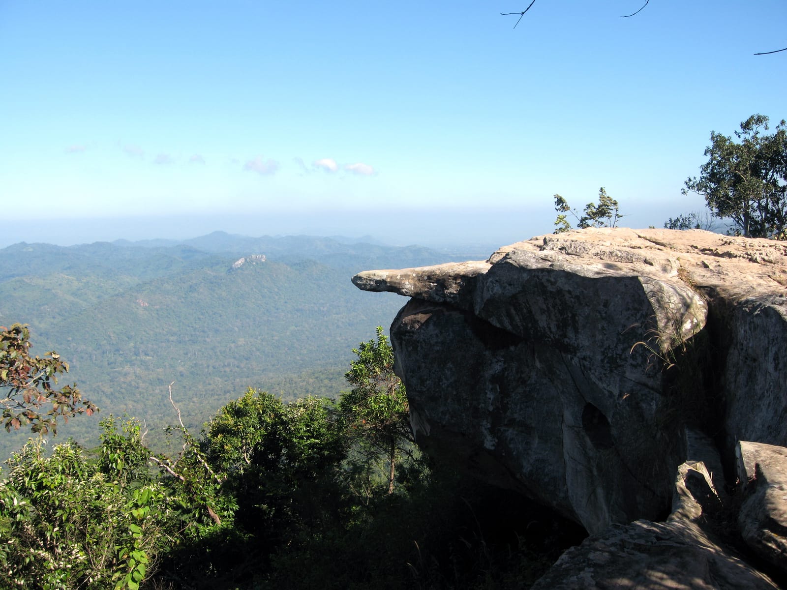
Pha Ham Hot — The Rock Ledge That Tests Your Nerves
Pha Ham Hot is inside Sai Thong National Park in Nong Bua Rawe district — a rock ledge that juts out past the cliff face on the Phang Hoei ridge, around 864 metres up. This is Sai Thong's most famous photo spot. People stand or sit with their legs dangling off the ledge and shoot with the hills below them, ending up looking like they're floating in mid-air. It was originally called Pha Nam Phueng (Honey Cliff) because bees nested under the ledge. This single angle is the reason people drive across provinces just to shoot it.
- Safety first — the ledge really does jut out, with no railing, and the wind is strong. Go one person at a time, don't edge out too far, and in the rainy season the rock gets slippery so take extra care.
- Go early for soft light and fewer people — during the Siam tulip festival the queue to photograph here gets long. Arriving right at opening makes it far easier.
- There's a fair bit of walking uphill — from the parking area you walk up a slope to the cliff point, so save some energy and bring water. Sneakers help a lot.
Pha Pho Mueang — A Long Cliff Line for Sunset
Pha Pho Mueang is also in Sai Thong, about 10 km from the park headquarters. It's a sandstone cliff line running roughly 3 km along the western Phang Hoei ridge, around 864 metres up, on the way to the Bua Sawan field. The draw is that along the whole length there are several smaller viewpoints to walk between — Pha Phloen Jai, Pha Athit Atsadong (Sunset Cliff), and Pha Suan Sawan. The names give it away: this is a fine stretch for watching the sun go down, because it faces due west.
Pair Pha Ham Hot with Pha Pho Mueang
These two are both in Sai Thong and on the same route — you can walk both in one day. Do Pha Ham Hot in the morning or midday when the light's open, then stay on for sunset at Pha Pho Mueang. Just plan your walk-back time well, because coming down the mountain after dark is no fun.
Pha Hua Nak, Phu Laen Kha — A View Many Say Doesn't Look Like Thailand
Pha Hua Nak is in Phu Laen Kha National Park, Tha Hin Ngom subdistrict, Mueang district. It's on the same route as Mo Hin Khao and just a little further along past it. It's a rock cliff that juts out like the head of a naga (the mythical serpent), at a bit over 900 metres. This spot is known for its wide-open view and sunset. In the rainy season wildflowers bloom along the path, while in the cool season you've got a chance at morning fog. The trail and parking are reasonably well set up, and the walk isn't hard.
- Pair it with Mo Hin Khao — same route, so in one day you can see the Mo Hin Khao stone pillars and the Pha Hua Nak viewpoint. Good value for your petrol.
- Closest to town in this group — around 35–40 km from Chaiyaphum town, ideal if you've got half a day but still want a cliff view.
- The final stretch climbs the mountain — a sedan can make it but drive carefully; the road is slippery in the rain, so check your brakes and tyres before heading up.
Pha Koeng — A Roadside Cliff Beside a Giant Buddha
Pha Koeng sits beside Highway 2159, the Chaiyaphum–Nong Bua Daeng road, about 36 km from town. It's a tall cliff shaped like a crescent moon — "koeng" means moon in the Isan dialect. On the cliff is Wat Chaiyaphum Phithak (Wat Pha Koeng), home to a large standing Buddha image around 14 metres tall. In front of the Buddha is a viewing terrace looking out over wide rice fields. The good thing about this spot is that it's on the way: you drive up and stop without any uphill hike. It suits anyone who wants an easy view, or who's already driving on to Nong Bua Daeng.
- Easy roadside stop — it's right on a main road; drive into the temple and walk to the terrace comfortably, with no entry fee.
- The access road has mountain curves — the climb up to Pha Koeng is fairly steep, so drive slowly and watch for oncoming traffic.
- Make merit and take photos — good for those on a temple visit: pay respects to the big Buddha and catch the rice-field view at the same time.
Siam Tulip Fields — Genuinely Pretty, but Seasonal
Many people come to shoot Chaiyaphum's cliffs because they also want the pinkish-purple Siam tulip (krachiao) fields as a backdrop. Both Pa Hin Ngam and Sai Thong have these fields. But let's make this crystal clear: the Siam tulips only bloom in the rainy season, roughly mid-June to August, with the peak usually late June into July. Outside that window you'll just see green grassland with no flowers. If you're set on photographing the blooms, always check the timing with the park's page first, because the rains come earlier or later from year to year.
Straight talk
If your goal is just the cliffs, you don't have to wait for the rainy season — the mountain views are good all year. The cool season (Nov–Feb) brings clear skies, cool air, easy walking, and a chance at the sea of fog too. But if you want both the cliffs and the flower fields in one frame, you'll have to accept the risk of rain and slippery trails between June and August.
How to Do Chaiyaphum's Viewpoints Without Wasting the Trip
Because each cliff sits in a different district, mapping your route ahead of time saves a lot of time. Here are two plans depending on how many days you have — adjust them for the season you're travelling in.
The Sai Thong line — Pha Ham Hot & Pha Pho Mueang
The Pa Hin Ngam + Phu Laen Kha line
Photo and Safety Tips
- Come at the right light — west-facing cliffs like Pha Pho Mueang and Pha Hua Nak look best in the evening, while Pha Sut Phaen Din is good both morning and evening. Time your visit to the direction it faces.
- A wide-angle lens helps — the mountain views are broad, so a wide angle captures more. For shots of someone standing on the cliff edge, have a friend shoot from the side to show the sense of height.
- Safety matters more than the shot — the rock ledges have no railing and the wind is strong. Don't jump or back up toward the edge, and always check your footing before setting up the camera.
- Pack for rain and sun — the weather on the mountain changes fast. Bring a rain jacket in the wet season and a hat and water in the hot season — there are no shops up at the cliffs.
- Respect the place — carry your rubbish out, don't pick the Siam tulips, and don't climb rocks the park has marked off-limits. Keep it intact so the people after you can see it as we did.
Plan a full Chaiyaphum trip — where to stay, eat and explore
See the Chaiyaphum travel guide →