🔄 Updated 21 Jun 2026
When people talk about nature in Nan, Doi Phu Kha is always the first name out of their mouths. The park covers more than 1,700 square kilometres across 8 districts and feeds the headwaters of both the Nan and Pua rivers. The park headquarters sits on a ridge in Pua district, around 24–25 kilometres from Pua town along Route 1256 (Pua–Bo Kluea). The appeal here isn't one single spot — it's the cool, forested mountain mood that follows you the whole way up.
Chompoo Phu Kha, the flower that grows nowhere else
Chompoo Phu Kha (scientific name Bretschneidera sinensis) is a rare tree that, in Thailand, is found only within Doi Phu Kha National Park. From late winter into early summer, roughly February to March, the tree drops its leaves and bursts into hanging clusters of pink blossom across the whole canopy — the high season that draws people to Nan specifically to see it. The easiest tree to spot stands right beside Route 1256, about 4 kilometres from the park headquarters, big and clearly visible from the road.
Straight talk about the bloom
Chompoo Phu Kha doesn't flower on a reliable schedule. Some years are heavy with blossom, others are thin, and the peak only lasts a few weeks. Before you go, check the park's Facebook page or call the headquarters (0-5470-1000) to ask when it's blooming this year, so you don't make the trip for nothing.
Want more out of Nan? Book tours & activities
Booking online ahead on Klook or GetYourGuide is usually cheaper than the gate and skips the queue. Pick only the experiences you actually want — prices and availability are shown live on each site.
The main spots on Doi Phu Kha
Viewpoint 1715
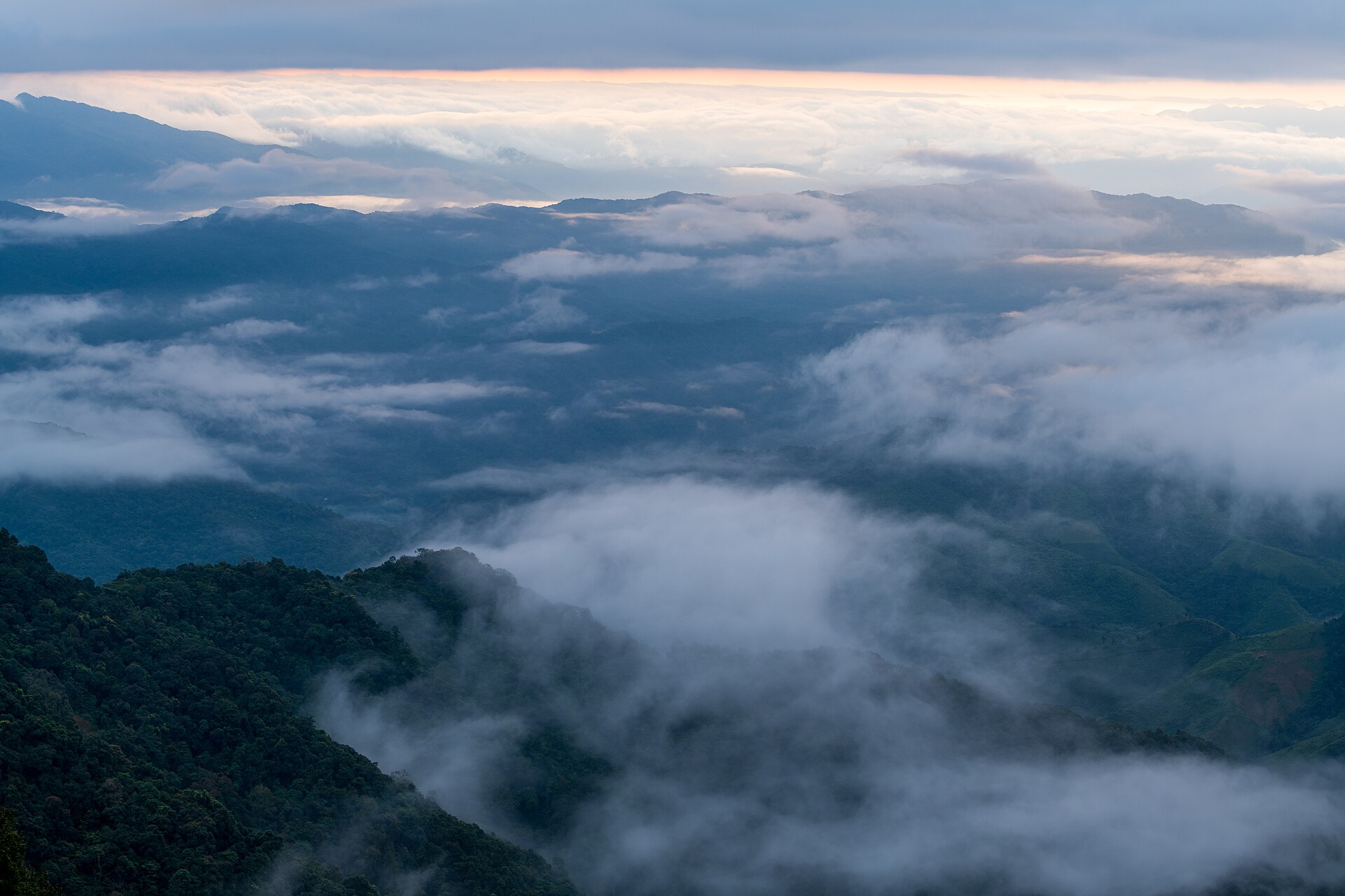
A roadside viewpoint on Route 1256, named for its 1,715-metre elevation. It's the most popular sunrise and sea-of-mist spot on Doi Phu Kha — early mornings the mist fills the whole valley. There's a car park and a camping area nearby.
Stargazing Field
An open clearing in the montane forest near the headquarters. By day it's one of the best sunset spots up here; on a clear night the sky fills with stars. It's also one of the park's camping zones.
Chompoo Phu Kha Nature Trail
A walking trail of about 3.5 kilometres starting near the headquarters, winding through montane forest past big old trees, rare plant species, and lookout points. Better for people who want to feel the forest rather than just drive past it.
Pha Khong Cave
A limestone cave with several chambers of stalactites and stalagmites, inside the park. You have to walk in and should bring a torch. More suited to cave explorers than families with small kids.
Another name you'll hear is Phu Fa Waterfall, the tallest waterfall in the park at around 140 metres with several tiers. But it's deep in the forest on the Mae Charim side, hard to reach and requiring a forest trek — it's not on the same route as the headquarters on the Pua side. If you're here on a single-day drive, you'll get more out of focusing on Viewpoint 1715, the Stargazing Field, and the Chompoo Phu Kha route.
The route from Pua — how to drive it
- From Nan town — take Highway 1080 north toward Pua district, about 60 kilometres, around an hour and a half.
- From Pua up to Doi Phu Kha — turn onto Route 1256 (Pua–Bo Kluea) from the centre of Pua and climb about 24–25 kilometres to the park headquarters. It's paved the whole way, but very winding and steep.
- The right vehicle — a regular car can make it, but make sure your brakes and engine are in good shape, because there are long steep descents. If you get carsick easily, bring something for it.
- Keep going — Route 1256 continues on to Bo Kluea and the elevated 1256 Skyroad, so many people roll it all into one trip.
Driving tips
The sea of mist is at its best at first light, which means leaving your accommodation in Pua before the sky lightens. Driving winding roads in the dark takes real focus — go slow, use your lights, and watch for heavy mist settling on the ridge and cutting visibility short.
Entry fees, accommodation & facilities
- Park entry fee — Thai adults 40 THB, children 20 THB (foreigners pay more). Cars 20 THB, motorcycles 30 THB.
- Park bungalows — several units, starting at around 800–2,000 THB per bungalow, plus small wagon-style cabins at around 300 THB (sleeps 2). Book ahead through the nps.dnp.go.th system — they fill up fast in the cool season.
- Camping grounds — several zones, including the Stargazing Field and one near Viewpoint 1715. You can rent tents and bedding at the park. It gets very cold in winter, so pack enough warm clothing.
- Food / supplies — there's a restaurant and a visitor centre at the headquarters, but options are limited. Buying water and snacks in Pua to keep in the car will give you more peace of mind.
Phone signal on the mountain comes and goes, so don't rely on online maps the whole way. Download an offline route or memorise the main path — Pua–1256–headquarters — before you head up.
The best time to go
- Nov–Feb — the cool season: clear skies and the best morning sea of mist. Cool to bitterly cold on the summit. This is the busy stretch, and accommodation fills up early.
- Feb–Mar — when the Chompoo Phu Kha tree blooms (it varies year to year). If you're set on seeing the flowers, aim for this window and check the news first.
- Rainy season (Jun–Oct) — the forest is deep green and there's plenty of mist, but the roads are slippery and parts of the route get thick fog. Drive with extra care.
Want a full Nan itinerary planned out so you don't have to think about it
See the Nan travel guide →