🔄 Updated 21 Jun 2026
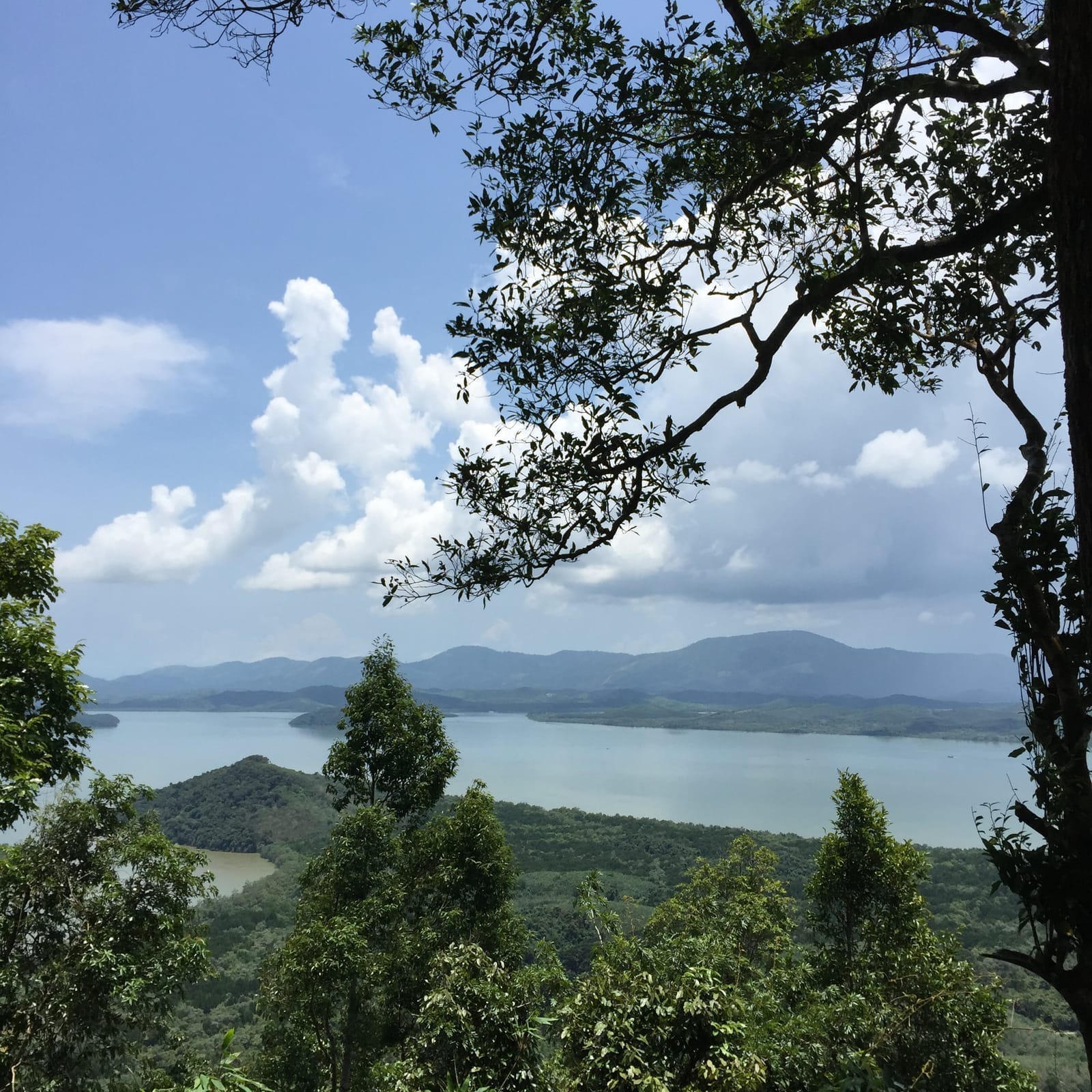
Ranong has plenty of viewpoints, but Khao Fachi tells the province's whole story in one shot, because this is the estuary that separates Thailand from Myanmar. Here the Kraburi river and the La-un river meet before flowing out into the Andaman Sea, so the foreground is a wide stretch of water, islands scattered across it like dots, and the Myanmar mountain ridge running along the far side. The name Khao Fachi comes from the mountain's shape, which looks a bit like a Thai food cover (fachi) placed over a tray.
Why morning beats sunset
A lot of sites talk up Khao Fachi as a sunset spot, and it genuinely is pretty in the cool season. But if you ask us when it's most comfortable to visit, we'll point you to the morning: the air is still cool, the light is still soft, and your odds of catching mist drifting over the water are higher — especially the morning after rain has just stopped, or in the late-rainy-to-early-cool season. The mist slowly burns off as the sun climbs, revealing the estuary bit by bit, and that's the most enjoyable stretch for taking photos.
- Softer morning light — the sun rises over the land side, so the water and the islands on the Myanmar side catch the light nicely instead of sitting in backlight like they do in the evening.
- Better odds of mist — it tends to form on still nights and drift up in the early morning, roughly 5 to 7 am.
- Cooler air — climb up late and the sun gets harsh; in the morning you can walk and shoot for much longer.
- Fewer people, fewer cars — parking at the top is tight, and you'll find a spot far more easily in the morning than at the evening sunset rush.
Want more out of Ranong? Book tours & activities
Booking online ahead on Klook or GetYourGuide is usually cheaper than the gate and skips the queue. Pick only the experiences you actually want — prices and availability are shown live on each site.
What you can see from the top
The viewpoint faces out toward the Kraburi estuary, the natural boundary between Thailand and Myanmar. From up on the hill, here's what you're looking at.
Kraburi estuary
The wide stretch of water where the Kraburi and La-un rivers meet before flowing out to the Andaman Sea — the star of the view, right in the centre of the frame.
Myanmar shore
The ridge and land of the Tanintharyi region of Myanmar sit on the far side of the river. On clear days you can see the line stretching out sharply.
Islands mid-water
Small islands scattered across the water as dots. Some days a thin mist drifts past and adds depth to the shot.
Lenses worth packing
The view is wide, so a wide-angle lens or your phone's panorama mode captures it well. But if you want to pull the Myanmar-side islands in closer, a zoom lens or your phone's zoom gives a different mood. Try shooting it both ways.
Getting there and the road up
Khao Fachi is in Bang Kaeo subdistrict, La-un district, about 30 km from Ranong town. Driving yourself is by far the easiest option, since no public transport goes up to the top. Take Highway 4 (Phetkasem) to around kilometre marker 580, where there's a turn-off signed "Khao Fachi Telecommunications Station". Turn in and keep driving up the hill for about another 3 km to reach the viewpoint.
- Opening hours — roughly 05:00–18:00, no entry fee.
- Distance from Ranong town — about 30 km, roughly a 40–45 min drive.
- The road up — narrow and steep in places; drive slowly and use low gear on the way down. A sedan can make it, but take care.
- Parking at the top — limited, room for only a few cars. When it's busy you may have to park on the roadside.
Driving up in the dark needs care
If you want to arrive before dawn to catch the first light, give yourself extra time and drive especially slowly — the road is narrow, unlit and has bends. Use high beams as far as it's safe and listen for oncoming cars. If it's just rained, the surface gets slippery.
Best times and seasons
The cool season is the peak time for Khao Fachi, roughly November to February — clear skies, cool wind, and the best chance of mist, especially in the late-rainy-to-early-cool stretch when humidity is still high. In the rainy season (May–October), Ranong gets a lot of rain, the view may be hidden by cloud and the road gets slippery. If you come in the rainy season, check the forecast first and be ready for the view to be a no-show.
- Nov–Feb — the best window: clear skies, cool wind, a real shot at mist.
- Mar–Apr — harsh sun but skies still open; come early and it's more comfortable.
- May–Oct — Ranong's rainy season: risk of cloud blocking the view and a slippery road. Always check the weather first.
What to know before you go (straight talk)
Khao Fachi is a simple, no-frills natural viewpoint — it isn't loaded with facilities. Its charm is purely the view, so come prepared and you won't end up disappointed.
- No café or restaurant at the top — if you want coffee with your view, bring it up yourself.
- Limited toilets — best to go before you head up the hill.
- Patchy phone signal — it's weak in spots, so save an offline map just in case.
- Take your rubbish back — this is a natural spot the crowds haven't fully found; let's keep it nice for the people who come after.
Where to go next after Khao Fachi
Come down from Khao Fachi by late morning and you've still got half a day left for Ranong. The route back into town passes several good stops, so it's easy to turn this into a one-day trip.
Raksawarin Hot Springs
Natural mineral hot springs in the middle of Ranong town — soak your feet to unwind after the drive up the hill. Free entry.
WaterfrontPak Nam Ranong, Thai–Myanmar border
See the Kraburi estuary at eye level — a fitting follow-up to the high view from Khao Fachi.
WalkableRanong Old Town
Sino-Portuguese buildings and old coffee shops — a nice afternoon stroll with plenty to photograph.
Want a full one-day Ranong plan that includes Khao Fachi?
See the Ranong 1-day plan →