🔄 Updated 21 Jun 2026
Khao Luang National Park covers the central Nakhon Si Thammarat range, spreading across several districts — Lan Saka, Phrom Khiri, Nopphitam, and Chang Klang. People often call this forest the southern rainforest, because it rains almost year-round and the humidity stays high, which keeps the forest deep green and feeds the streams that spill out as waterfalls all around the mountain. The side most travellers reach easily is the west, near Lan Saka and Phrom Khiri, where it's less than an hour's drive from town to the falls.
Khao Luang works at a few different levels — from driving out for a half-day at a waterfall and heading home, to shouldering a pack and hiking overnight up the highest peak in the south. This article lays out clearly how each version works, how tough it is, and who it suits.
What's at Khao Luang
A lot of people assume Khao Luang is a single waterfall or a single peak. It's actually a big park with spots scattered all around the mountain, each in a different district and reached by a different road. Before you plan anything, you need to know which side you're going to.
- Karom Waterfall (Lan Saka) — a big multi-tier waterfall near the western park headquarters. Easy to visit, and you can swim.
- Phrom Lok Waterfall (Phrom Khiri) — a scenic tiered waterfall that locals from Nakhon Si Thammarat visit often. A short walk up gets you to the standout tiers.
- Khao Luang summit, 1,835m (climbed via Khiriwong, Lan Saka) — an overnight hike to the highest peak in the south, for serious backpackers only.
- Krung Ching Waterfall (Nopphitam) — also inside Khao Luang but on a different side. It's a popular nature trail with its own separate article.
Straight talk
The attractions inside Khao Luang sit on opposite corners of the mountain. You can't comfortably drive from Karom over to Krung Ching in a single day. Pick a side first: the western side (Lan Saka–Phrom Khiri) is best for easy waterfall trips, while Krung Ching is on the northern side and needs to be planned as a separate trip.
Want more out of Nakhon Si Thammarat? Book tours & activities
Booking online ahead on Klook or GetYourGuide is usually cheaper than the gate and skips the queue. Pick only the experiences you actually want — prices and availability are shown live on each site.
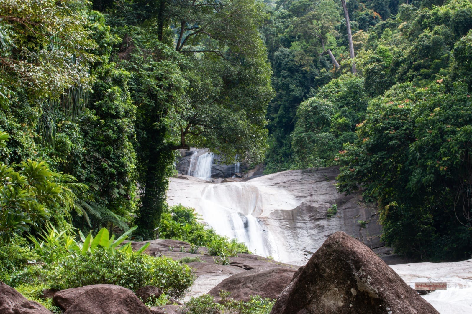
Karom Waterfall, the easy spot on the west side
Karom Waterfall is in Kamlon subdistrict, Lan Saka district, near the Khao Luang National Park headquarters. It's a big waterfall said to have as many as 19 tiers, stepping down a long stretch of boulders. The tier people talk about most is the 7th, known as Nan Dat Fa — a wide rock shelf where the water spreads down in a sheet. The lower tiers are easy to reach and have pools to swim in, which makes it good for a family picnic half-day.
Karom stands out because it's easy to reach but still shady and genuinely forested. The water runs clear and cold straight off Khao Luang. On weekdays it's quiet — you can sit and listen to the water in peace. On weekends locals like to picnic here, so the place gets livelier.
Phrom Lok Waterfall, the local favourite
Phrom Lok Waterfall is in Phrom Lok subdistrict, Phrom Khiri district — a waterfall the people of Nakhon have been attached to for a long time. It's said to have around 50 tiers, but the part open for walking up is roughly the first 4. Each tier has its own name and a pool to stop at, and a short walk up brings you to the pretty ones. It's an easy place to swim and good to bring kids. If you want the full trail and swimming-spot details, there's a separate Phrom Lok Waterfall article.
Tip
At both Karom and Phrom Lok, the rocks by the water are very slippery from algae. Wear shoes with good grip, and don't get in the water when it's running high after heavy rain — water down south rises much faster than it looks.
Climbing the 1,835m Khao Luang summit
The adventure highlight of Khao Luang is the summit itself, which hikers nickname "the eighteen-thirty-five" — it stands at 1,835 metres, the highest peak in all of southern Thailand. The popular route up starts from Khiriwong village in Kamlon subdistrict, Lan Saka district. It's an overnight hike done as 3 days and 2 nights, roughly 26 kilometres round trip, climbing through tropical rainforest into the cool, moss-draped montane forest up top that looks ancient, like you've slipped into another world.
This is not a stroll. The trail climbs steeply and steadily, the ground is slick, and in the rainy season there are a lot of leeches. You need to be in shape and to go with a team that knows the way. The park requires a ranger or porter guide to summit, advance registration, and it usually only opens for part of the year. Most people climb in the cool season when the rain eases and wildflowers come out on top — but that's also when it's busiest and you have to book a slot ahead.
Straight talk
The Khao Luang summit is genuinely brutal, and the view up top is often socked in by cloud. Plenty of people hike three days and never see a thing. The real draw of this route is the forest along the way and the challenge — not a guaranteed view. If you're hoping for a clear panorama, keep an open mind: it may not pan out.
How to reach the west side
The western side of Khao Luang is the closest to the city of Nakhon Si Thammarat, and driving yourself is the easiest option. Karom Waterfall and the park headquarters are in Lan Saka district, about 25–30 km from the city, roughly 40 minutes away. Phrom Lok Waterfall is in Phrom Khiri district, a similar distance. Both roads are paved and easy to reach, with the last stretch narrowing as it climbs to the mountain's base — drive slowly there when it rains.
- Private car — easiest by far, with parking at each waterfall. You can plan to visit 1–2 waterfalls in a day.
- Hired car or motorbike from town — good if you don't have a vehicle. It's not far; agree on the round-trip price in advance.
- The summit goes via Khiriwong — the climbing route starts at Khiriwong village. Contact a guide team and register with the park first.
Fees and opening hours
The waterfalls inside Khao Luang National Park charge the standard park rates — around 40 THB for Thai adults, half price for children, with a higher rate for foreign visitors, plus a small vehicle fee. If you camp overnight, add roughly 30 THB per person per night. It's open about 08:00–16:30. The summit route has separate fees plus porter and guide-team charges. You can ask the park headquarters ahead of time at 075-300494 or 075-300495. Rates may change, so check again at the gate.
Sample itineraries for Khao Luang
If you're still not sure which way to go, here are two plans that actually work. The first is for an easy half-day at the waterfalls, the second for backpackers heading for the summit.
Easy waterfall day on the west side (1 day)
Climb the 1,835m Khao Luang summit (3 days, 2 nights)
Manage your expectations
The summit route usually only opens for part of the year (most often the cool season) and requires booking a slot in advance. Some years the forest closes for recovery or shuts during heavy rain. Before you set your heart on the summit, contact the park or a guide team to confirm it's actually open for that period.
When's the best time to go
Khao Luang is a rainforest, so the waterfalls run at full force and the forest is greenest in the rainy season, roughly May to December. But in heavy rain the trails get slick and the water runs so high you can't swim some days. For an easy waterfall trip on the west side, the late-rainy-to-early-cool window is the sweet spot — the rain has eased but the water still has good flow. For the summit, people prefer the cool season, around December to February, when there's less rain, the trail is drier, fewer leeches, and some years wildflowers come out on top.
Where to stay and eat
The Lan Saka and Khiriwong side has plenty of village-run homestays and small resorts, especially Khiriwong village, which is a nature-tourism community with streamside stays and mountain-view cafes to choose from. It's a good place to spend the night listening to the water and wake up to visit the waterfalls in the morning. The park itself also has a campground for those who want to sleep close to the forest. For food, there are made-to-order spots and village eateries near the base of the mountain, focused on bold, fresh southern dishes. Bring water and snacks with you, though — there are no shops along the forest trails.
Waterfall day trip, out and back
Drive from the city of Nakhon, hit Karom and Phrom Lok, swim and head home. Good if you're short on time.
Overnight in Khiriwong
Sleep in the village below Khao Luang, visit the waterfalls and streamside cafes at an unhurried pace.
Summit climb, 3 days 2 nights
Backpack up to the highest peak in the south with a guide team. For adventurers only.
What to prepare before you go
- Shoes with good grip — the trails and the rocks by the water are slippery; sneakers or hiking shoes beat sandals.
- Leech medicine / leech socks — there are a lot of leeches in the rainy season, especially on the summit route. Worth packing for peace of mind.
- Drinking water and snacks — there are no shops along the forest trails, so carry your own.
- A warm layer if you're summiting — the montane forest and the peak are far colder than down below.
- Allow time to get back before dark — it gets dark fast in the hills, so start heading back before late afternoon.
Plan out more of Nakhon Si Thammarat's nature
See the Nakhon Si Thammarat travel guide →