🔄 Updated 21 Jun 2026
Read this before you plan — the border situation
Khao Phra Wihan National Park and the Pha Mo E Daeng viewpoint sit right on the Thailand–Cambodia border. In the past there have been notices to temporarily close Pha Mo E Daeng after tensions flared along the frontier, for visitors' safety. Before every trip, call the park headquarters (tel. 0 4582 6045) or check the Khao Phra Wihan National Park Facebook page and the latest border news. Don't rely on old photos in reviews — the open/closed status can change fast. Always have a backup plan.
Khao Phra Wihan National Park straddles Kantharalak District in Sisaket and Nam Yuen District in Ubon Ratchathani, covering roughly 130 square kilometres. Its southern edge follows the Phanom Dong Rak mountain range, which marks the border with Cambodia. The first thing most people picture is Pha Mo E Daeng, a sandstone cliff about 300 metres long where you can stand and look out across the Cambodian plains. Nearby there are also small ancient ruins that are older than the Preah Vihear temple itself, which makes this both a viewpoint, a historical site, and a patch of wild nature all at once.
Pha Mo E Daeng, the clifftop viewpoint
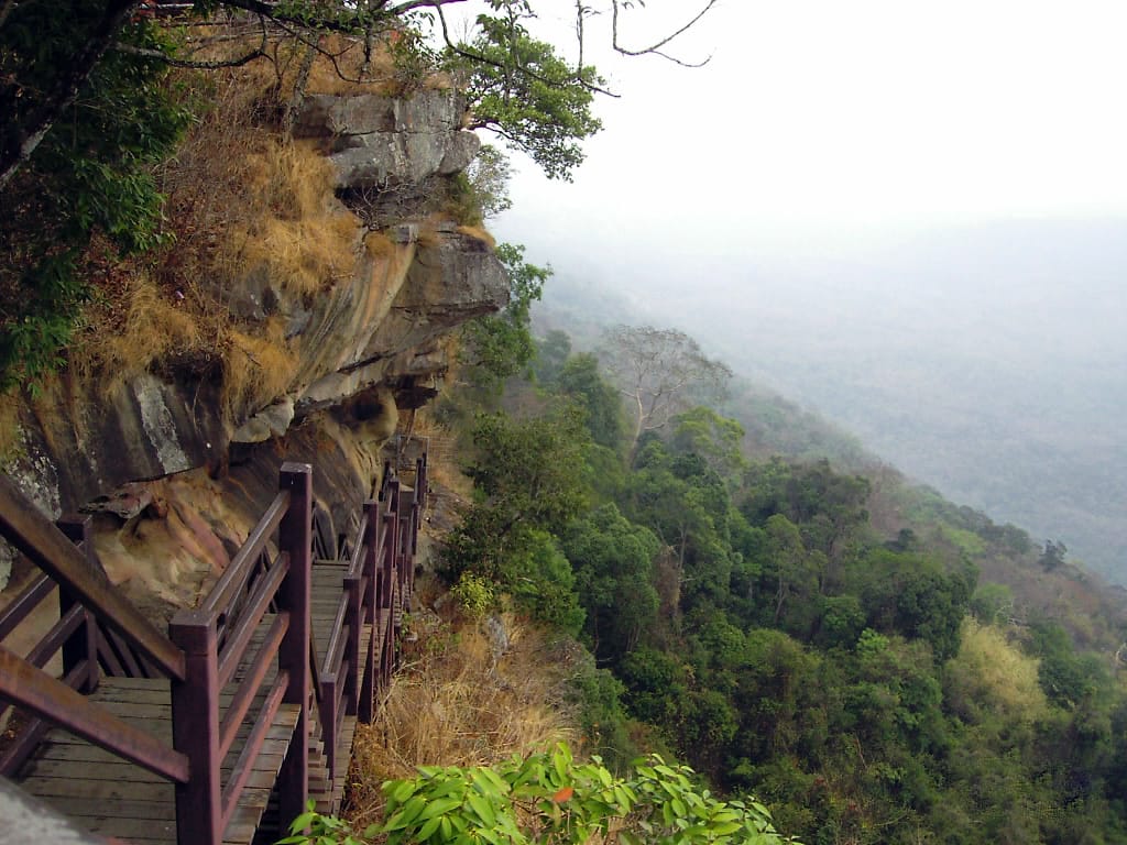
Pha Mo E Daeng is the steep cliff that anchors the whole park. A wide rock terrace lets you walk along the edge for about 300 metres, looking down over the forest and the Cambodian plains in a long panorama. On some evenings you'll see a stream of bats pouring out of a cave below the cliff — people who come late in the day like to wait around for it. The wind up on the cliff is strong and the sun is fully exposed, so bring a hat and water, and stay on the marked path the rangers set out, because some spots are close to the border line and areas that still need caution.
- Border view — a wide look down over the Cambodian plains and the Phanom Dong Rak range
- Evening bats — on some days a stream of bats flies out of the cave below the cliff around sunset
- Strong wind, harsh sun — it's an open rock terrace, so bring a hat, sunglasses, and drinking water
- Stay on the marked path — some spots are near the border, so keep to the trail and follow ranger advice
Want more out of Sisaket? Book tours & activities
Booking online ahead on Klook or GetYourGuide is usually cheaper than the gate and skips the queue. Pick only the experiences you actually want — prices and availability are shown live on each site.
The relief carvings below Pha Mo E Daeng
Below the Pha Mo E Daeng cliff there's a relief carving on the sandstone wall — three life-sized deities, thought to be around 1,000–1,500 years old, older than the Preah Vihear temple up on the summit. It's evidence that people used this area long before the temple was built. To go down and see it you have to take a stairway down along the cliff, and some sections may be closed depending on the situation, so ask the rangers at the service point first whether it's open to go down that day.
The Twin Stupa, a sandstone ruin
West of Pha Mo E Daeng stands the Twin Stupa, a pair of cube-shaped ruins built from sandstone, sitting side by side, about 1.9 metres wide and roughly 4 metres tall. They're in the Khmer style and symbolise fertility, with a yoni base and a lingam as part of the structure. Set in the middle of an open rock terrace, they're an easy walk to reach and a spot people like to stop and photograph against the wide sky.
- Built from sandstone — two square stupas side by side, ancient Khmer style
- Size — about 1.9 metres wide, roughly 4 metres tall, with a yoni base and lingam
- Easy to reach — not far from the Pha Mo E Daeng terrace, a popular photo spot
Waterfalls and nature in the park
Beyond the cliff and the ruins, the park also has small waterfalls and streams running through deciduous dipterocarp and dry evergreen forest. The waterfalls inside the park run highest late in the rainy season, around August to October, while in the dry season the water drops off a lot. If you're set on seeing the waterfalls, pick the period after the rains and check with the rangers first that the trail is open and safe to walk, because some routes run deep into the forest near the border and may close when the situation isn't normal.
The wild orchid nature trail
The park has a short nature trail of about 1.5 kilometres, focused on wild orchids and the many medicinal plants that grow on the rock terraces and in the shade. It's an easy walk, not too steep, and works for all ages who just want a gentle stroll through nature. The orchids bloom prettiest from late rainy season into early winter. Wear shoes with good grip, since some stretches of rock get slippery after rain, and carry your own water because refill points are limited.
- Distance — about 1.5 kilometres, not steep, suits all ages
- Highlight — wild orchids and medicinal plants on the rock terraces, prettiest late rainy season to early winter
- Come prepared — shoes with good grip, bring your own water, the rock gets slippery after rain
Entry fees, hours, and getting there
The park charges entry at the standard Department of National Parks rate — Thai adults around 40 THB, children around 20 THB, foreign adults around 400 THB, children around 200 THB, plus a vehicle fee depending on the type. Opening hours are generally around 08:00–16:30, but if you want to stay into the evening to wait for the bats, you'll need to ask the rangers how late visitors are allowed that day. The easiest way to get here is to drive yourself: it's about 100 kilometres from Sisaket town heading toward Kantharalak District, with the final stretch climbing up the mountain, so check your vehicle and fill up the tank before you start the climb.
- Entry fee — Thai adults around ฿40, children around ฿20 · foreign adults around ฿400, children around ฿200 (rates may change, check on site)
- Hours — around 08:00–16:30 · to stay into the evening for the bats, ask the rangers
- Getting there — driving yourself is easiest, about 100 km from Sisaket town to Kantharalak, with a mountain climb at the end
- Contact — park headquarters tel. 0 4582 6045 (check the open/closed status before you go)
Straight talk
This isn't a place you can just show up at without planning — between the distance, the mountain climb, and most of all the open/closed status that hinges on the border situation. Sometimes Pha Mo E Daeng is closed for long stretches, but other spots in the province like the Khmer temples or the volcanic-soil durian orchards are still open to visit. If you call to check and it's closed, don't feel bad — switch the plan to somewhere else and come back when things are normal. That's the better call.
A 2-day, 1-night Kantharalak–border itinerary
If the border situation is normal and the park is open, here's a rough plan that pairs Khao Phra Wihan with other things to do around Kantharalak, to make the long drive worth it. Adjust the timing as needed, and always keep a backup ready in case one spot is closed.
Into Sisaket town, then south to Kantharalak
Nature trail, Khmer temple, back to town
What to bring to Khao Phra Wihan
- ID card or passport, since it's a border area and there may be checkpoints
- Drinking water and a hat — the cliff terrace has harsh sun and strong wind
- Walking shoes with good grip — the rock gets slippery after rain
- Cash for the entry fee and the shops at the park entrance — phone signal is weak in some spots
- The park headquarters' number to call and check the status before and during the trip
Plan a full trip across Sisaket province
See the Sisaket travel guide →