🔄 Updated 21 Jun 2026
Krung Ching is the name of a small subdistrict in Nopphitam, north of Nakhon Si Thammarat town. The whole area sits inside Khao Luang National Park, one of the south's most intact stretches of tropical evergreen forest. What draws people here is the Krung Ching Waterfall nature trail: from the ranger station you walk about 4 kilometres into the forest to reach the main tier, passing several smaller falls along the way. Some you can swim in, others you can only sit and watch.
Why Krung Ching Is Special
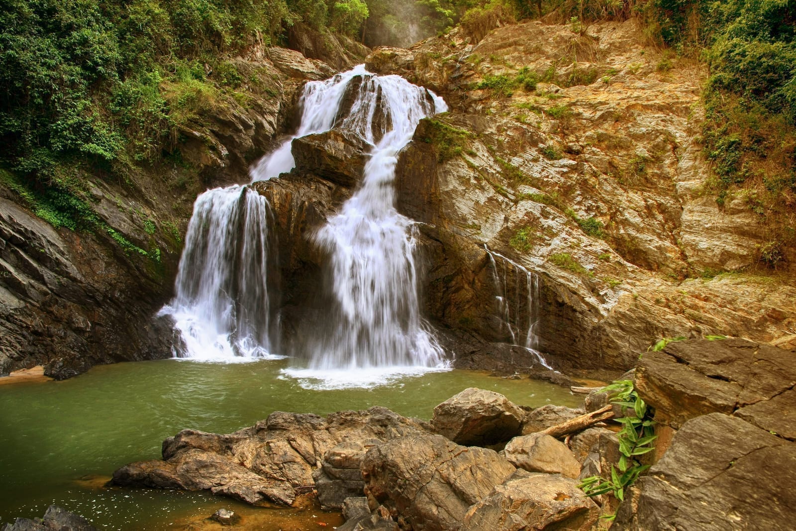
The highlight of Krung Ching is Nan Fon Saen Ha, the tier where water drops from a cliff more than 100 metres high and shatters into a fine spray that hangs in the air like rain all day. It was once beautiful enough to be printed on the old 1,000-baht banknote, which is why many people call Krung Ching the waterfall from the thousand-baht note. But the real charm isn't just that one tier. The whole trail stays shaded under big trees, with ferns, mushrooms, clear streams, and birdsong the entire way. It's a rainforest that's easier to walk than you'd expect.
Another thing people like is that it still isn't as crowded as the famous waterfalls elsewhere. On a weekday you might pass only a few groups, and you get a quiet and cool air that's hard to find in town.
Want more out of Nakhon Si Thammarat? Book tours & activities
Booking online ahead on Klook or GetYourGuide is usually cheaper than the gate and skips the queue. Pick only the experiences you actually want — prices and availability are shown live on each site.
The Waterfall Tiers and Nan Wan Kaeo
Krung Ching has seven tiers in total, each called a "nan" in southern Thai. Walking in from the trailhead you reach the lower tiers first, then gradually climb toward the upper ones. The tier most people aim for is Nan Fon Saen Ha, while Nan Wan Kaeo is a mid-trail tier with smooth rock and clear water — a good place to stop and take photos.
- Nan Wang Ruea Bin (Tier 1) — the lowest tier, close to the trailhead, with a shelter to rest. A popular swimming spot because it's a quick walk in.
- Nan Wan Kaeo — a mid-trail tier with a clear pool on a wide rock shelf. Not far to walk, ideal if you don't want to go all the way to the top.
- Nan Fon Saen Ha — the headline tier, with water falling from a high cliff in a curtain of spray. The most beautiful spot and the destination for most people.
- Other tiers — Nan Wung Chang, Nan Thong Ton, and Nan Chon sit along the way. Some you can only view from a lookout, not swim in.
Honest take
The names and order of the tiers aren't quoted exactly the same everywhere, and some trail signs have faded. If you want to be clear on which tiers are safe to swim, ask the staff at the ranger station before you set out — it's more reliable than guessing.
How Far Is the Hike, and How Long Does It Take?
The main trail from the ranger station to Nan Fon Saen Ha is about 8 kilometres round trip, roughly 4 kilometres each way. The climb up takes around 1.5 to 2 hours at an unhurried pace. Most of the path is a mix of paved sections, dirt, and steps, shaded throughout, with rest shelters at intervals. It isn't brutally steep, but there are uphill stretches that can tire you out. If you add time for swimming and photos, allow about half a day to most of a day — that's about right.
- Want a short walk — just stop at Nan Wang Ruea Bin and Nan Wan Kaeo near the start. Under an hour and you're already swimming.
- Want to go all the way — hike up to Nan Fon Saen Ha and allow about 3 to 4 hours round trip including rests.
- Coming with kids or older travellers — focus on the lower tiers; there's no need to push on to the very top.
Where Can You Swim?
The popular swimming spots are at the lower tiers, like Nan Wang Ruea Bin and the shallow pools around Nan Wan Kaeo. The water is clear and cold, coming straight off the Khao Luang headwaters. On a sunny day you can see the rock bottom clearly, but watch the current carefully — especially in the rainy season, when the water rises faster and runs harder than it looks. If the water is murky or flowing unusually strong, skip the swim. Sitting and watching is the safer call.
Safety
The rocks beside the falls are very slippery from moss, so wear shoes with good grip. Don't climb over the barriers to take photos near the cliff edge — every year someone slips because they got careless right there.
How to Get to Krung Ching
Krung Ching is in Nopphitam district, about 70 kilometres from Nakhon Si Thammarat town. Driving yourself is the easiest option and takes around 1.5 hours: take Highway 4015, then turn onto the road climbing up into Nopphitam. The final stretch is a winding mountain road, so drive carefully, especially on rainy days. There's no public transport that goes directly to the waterfall, so without your own vehicle you'll need to charter a car or catch a songthaew from the district centre.
- Private car — the most convenient. There's a parking area at the ranger station before the walk begins.
- Chartered car from town — good if you'd rather not drive the mountain roads yourself. Ask for the round-trip price in advance.
- Fill up before the climb — fuel stations are scarce around Nopphitam, so top up in town or a larger district first.
Entry Fees and Opening Hours
The waterfall is inside Khao Luang National Park and charges the standard park rates: roughly 40 THB for Thai adults, 20 THB for children/students, and 200 THB for foreigners, plus about 30 THB per car. It's open from around 8:30am to 4:30pm, but you should start walking before noon to leave time to get back before the forest goes dark. Rates can change, so confirm with the staff at the gate.
When Is the Best Time to Go?
Krung Ching is a rainforest, with the most water and greenery in the rainy season, roughly May to December. The falls run at full strength and the spray looks its best. But in heavy rain the trail gets slippery and the water can run too high to swim. If you want an easy hike and a proper swim, the late-rain-into-cool-season window — or early in the year when the rain eases but the water still has force — is the sweet spot. In a hard dry spell the water can drop off.
Where to Stay, Where to Eat
Around Krung Ching there are several small homestays and resorts run by locals, like the Krung Ching Homestay group — good if you want to stay overnight, fall asleep to the sound of the forest, and wake up for an early-morning hike. For food, there are made-to-order shops and local eateries near the foot of the hill before the waterfall, friendly on price and focused on fresh southern Thai cooking. Pack water and snacks to carry up with you, because there are no shops along the trail.
Stay at a Krung Ching homestay
Spend the night in the community, wake up and hike comfortably. Quiet, cool air down in the valley.
Day trip in and out
Drive up from Nakhon Si Thammarat town in the morning, hike and swim, then head back. Good if you're short on time.
Pair with Ban Khiriwong
Do the nature in Nopphitam, then continue to Khiriwong village on the other side of Khao Luang. Great for nature lovers.
What to Prepare Before You Go
- Shoes with good grip — the path is slippery, especially the rocks by the water. Sneakers or hiking shoes beat sandals.
- Leech socks / leech repellent — leeches are common in the rainy season, so it's worth having for peace of mind.
- Drinking water and snacks — there are no shops along the trail, so bring your own.
- A spare set of clothes and a dry bag — if you plan to swim, bring a change of clothes and something to keep your phone dry.
- Allow time to get back before dark — the forest darkens fast, so start heading back before late afternoon.
Keep planning a full nature trip around Nakhon Si Thammarat
See the Nakhon Si Thammarat travel guide →