🔄 Updated 21 Jun 2026
Nong Bua Lamphu's landscape breaks down roughly into three zones: the mountains to the west and south, ridges of rock and dry dipterocarp forest; the water to the south on the Non Sang district side, the tail end of the reservoir above Ubol Ratana Dam; and the plain in the middle of town, with the city lake at its heart. Most of the nature sits within an hour's drive of the city, so it's easy to cover even if you only have a day or two.
We've arranged things by zone, starting with Phu Kao-Phu Phan Kham National Park as the main nature draw, then the reservoir on the Non Sang side, then moving closer to town with Thao To Waterfall and the city lake, and finishing with the linking routes and what to pack. Each spot has its own deep-dive article already; this one gives you the overview of what's where and how to pair them.
Phu Kao-Phu Phan Kham National Park — Rock Mountains and Ancient Traces
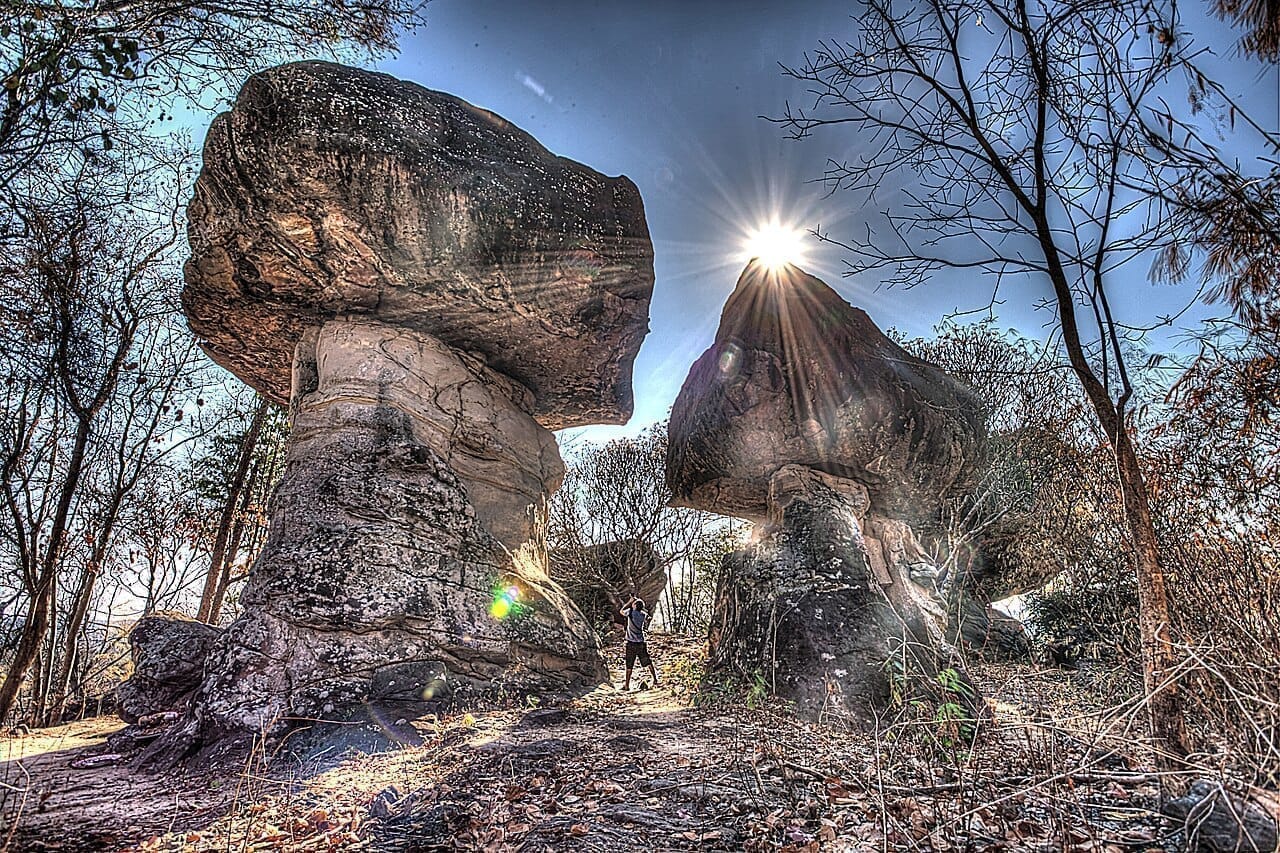
Phu Kao-Phu Phan Kham National Park is the largest nature area in the province, covering Non Sang district in Nong Bua Lamphu and running down into Ubol Ratana district in Khon Kaen. The name comes from two clearly different mountain groups: Phu Kao on the Nong Bua Lamphu side, known for oddly shaped rock formations and prehistoric rock paintings, and Phu Phan Kham, a long ridge running alongside the lake above Ubol Ratana Dam.
- The Phu Kao side — rock shelves and stacked boulders that look like castles and mushrooms, rock paintings on cave walls, and Wat Phra Phutthabat Phu Kao with carvings in the stone. Good for walking, photos, and seeing the historical traces.
- The Phu Phan Kham side — high viewpoints looking down over the water above Ubol Ratana Dam stretching as far as you can see. The sunset over the lake in the evening is especially nice.
- Camping — there's a campground and a park headquarters where you can sleep to the sounds of the forest, good for campers who want to wake up to a thin morning mist in the cool season.
Make the rock paintings worth it
The rock paintings fade over time, and they show up clearest in the angled light of early morning or late afternoon, not at noon when the sun is straight overhead. Never touch them with your hands or splash water on them to deepen the color — that damages the paintings permanently. If you can't find a spot, ask the staff at the park headquarters to point the way.
Want more out of Nong Bua Lamphu? Book tours & activities
Booking online ahead on Klook or GetYourGuide is usually cheaper than the gate and skips the queue. Pick only the experiences you actually want — prices and availability are shown live on each site.
The Reservoir Above Ubol Ratana Dam — Wide Open Water on the Non Sang Side
Ubol Ratana Dam belongs to Khon Kaen, but the reservoir above it spreads all the way into Nong Bua Lamphu at Non Sang district, right where the Phu Phan Kham ridge runs along the shore. This side has fewer people than the Khon Kaen side, it's quieter, and you get mountains reflected in the water that look great in the morning and evening. It's the side locals prefer for sitting and chilling by the water, more than the dam itself.
Phu Aen Skywalk (Non Sang)
A viewpoint on the Phu Phan Kham ridge with a walkway that juts out over the cliff, looking down at the reservoir with islands scattered below. The light is lovely morning and evening, the breeze is cool all the time, and it's good for photos and just sitting in the wind.
Non Yao Beach (freshwater 'sea')
A sandy beach along the reservoir that locals call the freshwater sea. In the dry season the water drops and the wide beach appears, you can wade in the shallows, and there are restaurants and floating rafts to sit and eat by the water. Good for a relaxed family outing.
What you need to know about water levels
The reservoir rises and falls with the seasons. From the rainy season into early winter the water is full and the view is great, but the sandy beach goes underwater. In the dry season (roughly March to May) the water drops, the wide beach appears, and it's good for swimming. If you're coming specifically for the beach, aim for the dry season; if you want the full-water view, come at the end of the rains.
Thao To Waterfall — The Rock-Shelf Waterfall Closest to Town
If you don't want to drive far, the closest waterfall to town is Thao To Waterfall, a forest park right off Highway 210, the Nong Bua Lamphu–Udon Thani road, only about 3 kilometers from the city. It's a low waterfall where the water runs across a wide sheet of rock, with big boulders to sit on and spots to lay out a mat and eat under the shade of the trees. Nong Bua Lamphu locals think of it first when they want to escape the heat close to home. Entry is free since it's a forest park.
- Location — off Highway 210, Non Than subdistrict, Mueang district, about 3 km from town, a 5–10 min drive.
- Best water — the rainy season, roughly July to early October, when the water fills the rock shelf. In the dry season it usually dries up and leaves just the rock.
- Add it on — the same area has the Pu Lup shrine, where people like to pray for safe travels, so it makes a neat half-day trip.
Nong Bua — The City Lake That Gave the Province Its Name
In town there's a big lake called Nong Bua, which is where the province gets its name. It's a low-lying water area in the middle of town where locals come to walk, run, cycle, and sit by the water in the morning and evening. Around the lake there's the shrine of King Naresuan the Great and a public park, making it a downtown rest spot you don't have to drive anywhere to reach. Good to drop by in the morning before heading out, or in the evening once you're back in town.
Nong Bua isn't a flashy spot, but it reflects local life here well. Come in the evening and you'll see people out exercising and vendors setting up snack stalls along the path — an easy, small-town atmosphere. It's pleasant to wander and photograph the bridge over the water.
Nature Routes for Nong Bua Lamphu
The spots are spread out but not far apart, and driving yourself is by far the easiest way since public transport doesn't reach the park or the reservoir shore. We've laid out two days, so pick and choose to fit the time you have: one day to focus on what's near town, two days to go deeper into the mountain and water side.
Near town — Nong Bua + Thao To Waterfall
Mountains and water — Phu Kao-Phu Phan Kham + Non Sang reservoir
Before You Go
- Season — waterfalls run best in the rainy season (Jul–early Oct), mountain views with light mist come in the cool season (Nov–Feb), and the sandy reservoir beach is best in the dry season (Mar–May).
- Transport — you'll want your own car, or rent a motorbike in town; public transport doesn't reach the park or the reservoir shore. Fill up the tank before heading into the mountain zone.
- What to bring — non-slip shoes for the waterfall rock shelf, a warm layer for the mountains in the cool season, and mosquito repellent for the forest and waterside.
- Phone signal — the signal is weak in spots inside the park, so save your route offline beforehand.
- Etiquette — carry your trash out, don't touch the rock paintings, and follow the warning signs at deep water and cliff edges.
A local's tip
If you only have one day and you're coming in the rainy season, put your time into Thao To Waterfall and Nong Bua near town — it's worth more than driving far. But if you're coming in the cool season or you have two days, then go deeper into the Phu Kao side and the Non Sang water, because the mountains reflected in the water and the cool breeze on the skywalk are far nicer in that window.
See all the things to do in Nong Bua Lamphu and plan your nature trip
Nong Bua Lamphu travel guide →