🔄 Updated 21 Jun 2026
Pattani's landscape is more varied than most people expect. The north is Gulf of Thailand coastline with sandy beaches, headlands, and the wide curving Pattani Bay full of mangroves. The south of the province runs into the Sankalakhiri Range, with waterfalls and shady forest — so you can do both the sea and the mountains in a single province. We've split the nature spots into a sea–sandspit–mangrove zone in the north and a waterfall–forest zone in the south, to make planning a route easier.
Before you plan your trip
Pattani is one of Thailand's three southern border provinces. Before you actually go, check the latest news and safety advisories from official agencies and local media, then pick your timing and route based on the situation. Most travellers visit the main nature spots without issue, but updating your information before setting out is always worth doing. Some spots, like the mangroves or the tip of the sandspit, need a boat — ask locals and check the weather first. And when you're in the Malay-Muslim communities here, dress modestly and respect local ways.
Talo Kapo Beach — kolae-boat beach on the Gulf
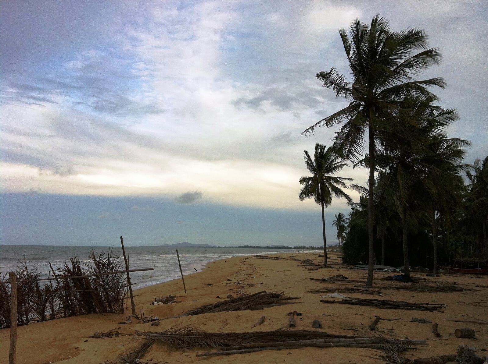
The beach that comes to mind first when people talk about the Pattani sea is Talo Kapo, in Talo Kapo subdistrict, Yaring district, about 15 kilometres east of town along Highway 42. It's a long stretch of white sand running parallel to the coast, and the signature image is the kolae boats and local fishing boats lined up along the shore. The name comes from "talo" meaning bay and "kapo" meaning lime — from the old days when shells were burned to make lime. There are seafood restaurants and shaded stalls to sit at, and in the evening it's a sunset spot locals like to come to. The atmosphere is a simple local beach, not a luxury-resort beach like the Andaman side, but you get to see real fishing life, and the communities around the beach still have healthy mangrove forest.
- Location — Talo Kapo subdistrict, Yaring district, about 15 km from town along Highway 42
- Highlights — kolae boats along the shore, long sandy beach, evening sunsets
- Things to do — stroll the beach, eat seafood, watch local fishing life
- Good for — people who prefer quiet local beaches over tourist ones
Want more out of Pattani? Book tours & activities
Booking online ahead on Klook or GetYourGuide is usually cheaper than the gate and skips the queue. Pick only the experiences you actually want — prices and availability are shown live on each site.
Laem Tachi — the long sandspit in the Gulf
Just beyond Talo Kapo is Laem Tachi, also known as Laem Pho, in Yaring district. It's a sandbar that juts out into the Gulf of Thailand in a long line parallel to the mainland — roughly 16 kilometres long, narrow, with sea on both sides, and the tip keeps growing a little every year. The views here are wide open, looking across to the city of Pattani on the far side and out to the mouth of the bay. It's fairly quiet and calm, good for anyone who wants to take photos, sit in the breeze, and watch the sunrise or sunset without crowds. Worth knowing: there are few shops or facilities out near the tip, and reaching some sections means taking a boat across from the town side, or asking locals about the route first.
Tip
Talo Kapo Beach, Laem Tachi, and the Yaring mangroves are all in the same area around Yaring district, so you can string them together in one loop. If you're taking a boat out to the tip of the spit, go during the day, check on boats and the wind and waves with locals first, and bring your own water and snacks since they're hard to find out there.
Yaring Mangroves — boardwalk and boat trips
Pattani Bay is a wide curving bay with a large, healthy stretch of mangrove forest. The easiest spot to visit is the Yaring Mangrove Nature Study Centre, on the bank of Khlong Yamu opposite the Yaring district office. There's a wooden nature boardwalk that loops through the forest for over a kilometre, where you can walk through the mangrove ecosystem and see fiddler crabs, mudskippers and birds along the mudflats up close. Another option that's catching on is a community-run boat trip through the mangroves — around the Ban Bang Pu area, for instance — that takes you through tunnels of mangrove and out to see flocks of birds in Pattani Bay. The boat trips are community tourism, so contact the local groups ahead of time and ask about prices and departure times before you go.
- Yaring Mangrove Nature Study Centre — wooden nature boardwalk looping through the mangroves, on Khlong Yamu, Yaring district
- Community boat trips (e.g. Ban Bang Pu) — local fishing boats through mangrove tunnels, birdwatching in Pattani Bay
- Good for — nature lovers, families, anyone into birds and ecosystems
- Come prepared — contact the community tourism group ahead, bring bug spray, wear a sun hat
Pattani Skywalk — a walkway above the mangroves
A check-in spot that's taken off lately is the Pattani Skywalk, a raised steel-mesh walkway running out over the mangrove forest around Suan Mae Luk on the edge of Pattani Bay. The walkway is several hundred metres long, with rest points along the way to stop and take in the view — on one side you see the mangroves, Pattani Bay and the line of Laem Tachi, and on the other you can make out Khao Sai Khao or Khao Rangkiap in the distance. It's a light activity that gives you a high vantage point without any mountain hiking, ideal to tack on after sightseeing in town or around the Yaring sea zone. People like coming in the evening to watch the sun set over the bay. Before you go, check the opening hours and the latest local situation again, since it sometimes closes for maintenance.
Ao Manao & the east coast — long, quiet beaches
Past the Yaring zone, the province's east coast has several more long stretches of sandy beach. Ao Manao is the name locals here use for the curving bay that runs along the eastern sea of Pattani — an open, quiet beach where villagers come to sit and head out fishing, with few outside visitors. It's good for anyone who genuinely wants a calm beach to sit in the breeze and photograph fishing life. One thing to note: the more famous Ao Manao, which is a national park, is over in neighbouring Narathiwat province. If you want the Ao Manao with full facilities, many people drive on over to the Narathiwat side, which doesn't take long — so you can plan a continuous trip across both provinces.
Tip
Pattani's east coast runs straight on into Narathiwat. If you have the time and the situation allows, try planning a two-province coastal trip in one go — start with Talo Kapo Beach and Laem Tachi on the Pattani side, then continue to Ao Manao on the Narathiwat side, which has a longer beach and more complete facilities.
Sai Khao Waterfall — multi-tiered falls in the Sankalakhiri Range
If you want to swap the sea for forest and hills, drive south toward Khok Pho district to Sai Khao Waterfall National Park. The falls are in the Sankalakhiri Range, which forms the border of Pattani, Yala and Songkhla, with several tiers flowing over the rocks — clear, cool water you can swim in when the flow isn't too strong. The surroundings are shady forest with nature trails and a campground. In the same area there's also Pha Phaya Ngu and Wat Sai Khao, the community's old temple. The cool, shady setting suits families and anyone who wants to relax in nature. The water is at its best after the rainy season, when it's fuller and clearer. There's a park entry fee at the standard national park rates.
- Location — Sai Khao subdistrict, Khok Pho district, Pattani, via the Pattani–Yala route
- Things to do — swim at the falls, walk the nature trails, camp, visit Wat Sai Khao
- When to go — after the rainy season, when water is fuller and clearer (park entry fee at standard national park rates)
- Nearby — Pha Phaya Ngu and Wat Sai Khao, in the same community
Khao Rangkiap viewpoint — a southern sea of mist
Within Sai Khao Waterfall National Park there's also the Khao Rangkiap viewpoint, known for its morning sea of mist, looking down over the plains, the communities, and the Pattani sea in the distance. Up on the hill there's a Buddha image and the Twad Rangkiap shrine that locals hold in reverence. It's a spot photographers and hikers like to come to for the sunrise. The key thing to know is that the road up Khao Rangkiap has had periods of closure for construction and improvement, so its open/closed status can change — before you go, call the park office or check the latest information to be sure, so you don't make the trip for nothing.
Kolae boats — a craft tied to the Pattani sea
The image that defines the Pattani sea is the kolae boat — the traditional Malay fishing boat with a pointed bow and stern, painted and decorated with bold, vivid patterns. You'll see them along Talo Kapo Beach and in the fishing villages around the bay. The village best known for building and painting kolae boats is Ban Pase Yawo in Sai Buri district, where boat-builders still work today. Come here and you can see the whole building process and the patterns up close — an art form passed down over many generations. It's good for anyone interested in local culture and craft alongside a trip to the sea. If you want to look around or photograph the craftsmen, ask and request permission from the homeowners politely.
How to plan a Pattani nature trip
Pattani's nature splits into two main zones: the sea–mangrove zone in the north (Talo Kapo Beach, Laem Tachi, the Yaring mangroves, the skywalk, and the east coast toward Ao Manao) and the waterfall–forest zone in the south (Sai Khao Waterfall, Khao Rangkiap, Khok Pho). The two zones are on opposite sides of town, so you can comfortably plan them over two days — one day focused on the sea and mangroves, the other on the waterfall and mountains. Below is a sample two-day route to adjust to your time and the situation.
Sea, sandspit and mangroves
Waterfalls, mountains and craft
Things to know about getting there
Pattani has no airport in the province itself. Most people fly into Hat Yai and then drive about 1.5–2 hours, or take a train or coach to Pattani. For nature spots spread this far apart, the most convenient option is your own car or a rental, since public transport to the waterfalls and the spit is limited. Some activities, like the mangrove boat trips, need to be arranged in advance — and don't forget to check local safety news before every trip out.
Plan your stay and a full Pattani trip
See the Pattani travel guide →