🔄 Updated 21 Jun 2026
Phu Hin Rong Kla sits where three provinces meet — Phetchabun, Phitsanulok, and Loei. The park headquarters is on the Nakhon Thai side in Phitsanulok province, but most people travelling through Phetchabun come in via Lom Kao district and over Phu Thap Boek, because it falls along the same route. The park covers around 307 square kilometres at an elevation of roughly 1,200–1,600 metres, so the air stays cool nearly all year and mist rolls in often enough to become the place's signature.
What sets Phu Hin Rong Kla apart from the other peaks in Phetchabun is that it tells two stories at once: nature shaping rock fields into odd forms, and a chapter of Thai political history that genuinely played out on this mountain.
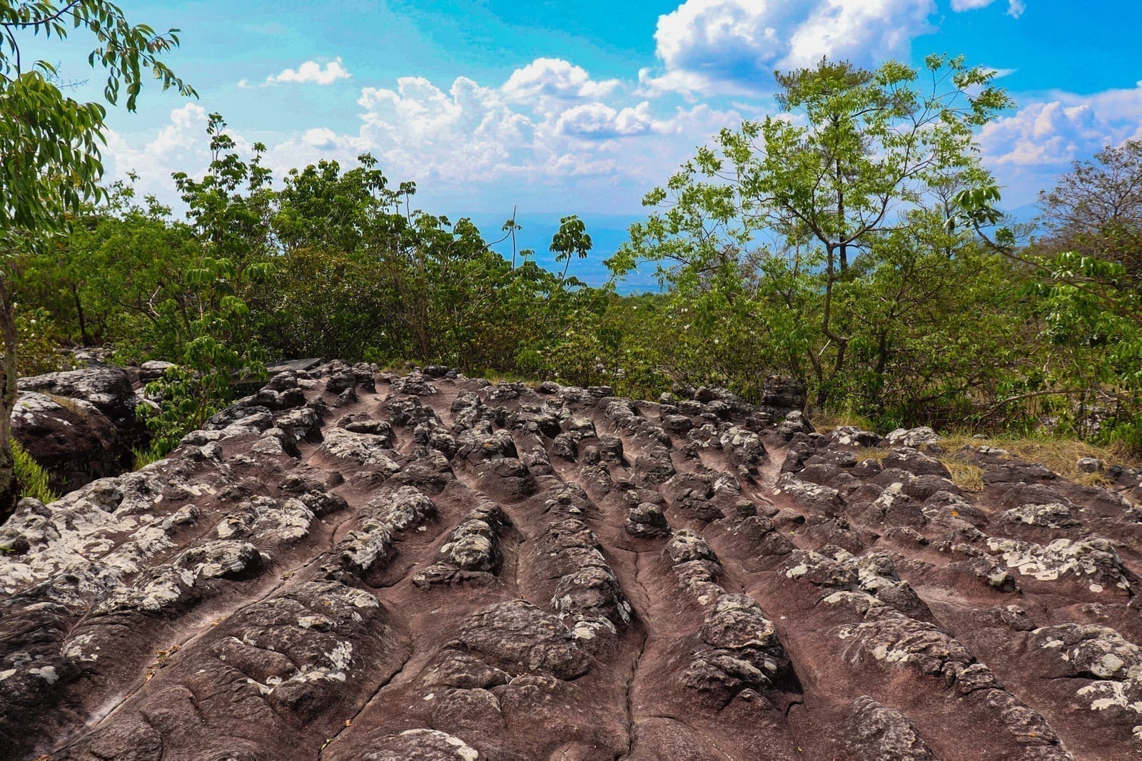
Lan Hin Taek — the cracks nature carved itself
The cracked rock field (Lan Hin Taek) lies about 1 kilometre from the park headquarters, an easy walk. It's a wide sandstone plateau split by deep cracks that look like the ground pulling apart, formed by subsidence and erosion over millions of years. Some cracks are wide enough to stand inside, and the crevices are green with moss, ferns, and lichen. In late rainy season into early winter, small wildflowers come up along the grooves.
Wear proper shoes
The cracked rock field has uneven footing — in places you have to step across gaps, and the rock gets very slippery when wet with mist or after rain. Sneakers or hiking shoes with good grip are safer than sandals.
Want more out of Phetchabun? Book tours & activities
Booking online ahead on Klook or GetYourGuide is usually cheaper than the gate and skips the queue. Pick only the experiences you actually want — prices and availability are shown live on each site.
Lan Hin Pum — a short loop with views at both ends of the day
The knobby rock field (Lan Hin Pum) is on the other side of the park — a plateau studded with rounded knobs of rock, large and small, scattered across the whole field, again shaped by water and wind erosion. This is the broadest viewpoint over the forest below, and it works as both a sunset spot in the evening and a sea-of-mist spot in the morning, all in one place.
The Lan Hin Pum nature trail runs about 2.7 kilometres in a loop back to the start. Most of it is flat with clear signs, so even casual walkers can manage it, and it takes around 1–1.5 hours at an unhurried pace.
- Lan Hin Pum — the field of rounded rock knobs covering the ground, the main photo spot on this trail
- Pha Chu Thong — about 500 metres from Lan Hin Pum, a viewpoint cliff that doubles as a historic site
- Sunset viewpoint — in the evening the light spills across the rocks, the most popular time of day here
Pha Chu Thong — where a flag was once raised in resistance
Pha Chu Thong is a steep cliff looking down over layered ridges of forest. The name (literally "flag-raising cliff") comes from the past: this was where the Communist Party of Thailand raised its flag above the cliff during the time it held this area as a base. Today only the wide view and the cool wind remain, but knowing the history gives standing here a different feeling. In the morning the mist often sits below the cliff line, so the sea of mist shows up clearly.
Traces of the past — when this mountain was a battlefield
Between 1968 and 1982, Phu Hin Rong Kla was a command base of the Communist Party of Thailand (CPT). Its steep terrain and thick forest made it a stronghold that was hard to assault, and fighting with government forces dragged on for nearly 15 years. The situation eased by 1982, and the area was declared Thailand's 48th national park on 26 July 1984.
Within the park, traces of that era are still kept for visitors to walk through, most of them not far from the headquarters. It's worth stopping if you want to understand why this mountain carries the name it does.
Political-Military School
The former training and education centre of the CPT. Today wooden building remains and foundations are left to walk among, about 4 kilometres from the headquarters.
Battle Museum
Displays weapons, medical instruments, and everyday items from the era, helping you picture life on the mountain more clearly.
State Power Office & Air-Raid Shelter
The command post and air-raid shelter dug into the forest, reflecting how people lived during the fighting.
Waterfalls in the park
Beyond the rock fields and historic sites, Phu Hin Rong Kla also has several waterfalls, at their best in late rainy season. Some require a hike in, and you should let the rangers know before you go.
- Man Daeng Waterfall — a large waterfall of around 32 tiers that flows year-round; it takes a real trek to reach and suits people who want a proper trail
- Rom Klao–Pharadon Waterfall — about 3.5 kilometres from the headquarters with a short walk in, a waterfall many people stop at
- Pha Lat Waterfall — a small roadside waterfall, an easy photo stop along the way inside the park
Rain and mist
Phu Hin Rong Kla gets heavy rain, and mist can roll in even on a sunny day. Always pack a rain jacket and a warm layer, even in the hot season, because mornings and evenings are far cooler than the lowlands.
Getting there — entering from the Phetchabun side
The park has two ways in. Travellers around Phetchabun usually come in via Lom Kao district over Phu Thap Boek, since it's the same route and lets you see both places in one trip. The other way is from Nakhon Thai district in Phitsanulok province, where the park headquarters is located.
- From Phetchabun town — drive up via Lom Sak–Lom Kao, then continue up to Phu Thap Boek; from Phu Thap Boek a road runs on to Phu Hin Rong Kla, around 100 kilometres total, so allow 2.5–3 hours for the winding mountain road
- From Phitsanulok — take the Phitsanulok–Lom Sak road about 68 kilometres to the Ban Yaeng junction, turn off toward Nakhon Thai district for another 30 kilometres or so, then continue up to the park
- No car of your own — take a bus to Nakhon Thai or Lom Kao, then hire a songthaew or local vehicle up to the park; arrange a pickup time in advance
About driving the mountain
The roads up to Phu Hin Rong Kla and Phu Thap Boek are steep and very winding. If you're driving yourself, your car needs strong brakes and a sound engine — some small automatics struggle on the steepest stretches. Use a low gear on the way down to spare your brakes.
Entry fees, hours, and where to stay
- Entry fee (Thai nationals) — adults 40 THB, children 20 THB, 30 THB per car; foreign visitors pay a higher rate
- Hours — open daily, roughly 06:00–18:00; the visitor centre is open during the daytime
- Accommodation — there are park bungalows and campsites inside the park, with bungalow prices ranging from a few hundred to a few thousand THB by size, booked through the national park system; there are also homestays and private guesthouses around Ban Rong Kla to choose from
If you want both the morning sea of mist and the evening sunset in one trip, staying overnight on the mountain beats a day trip, because the most beautiful windows are dawn and dusk — which you'd miss driving up and down in a single day. In high season from late rainy season into winter (October–January), bungalows fill up fast, so book ahead.
Planning a 2-day, 1-night trip
Up the mountain for the rock fields and sunset
Morning sea of mist, the history, then back down
Plan a full Phetchabun trip across the whole province
See the Phetchabun travel guide →