🔄 Updated 21 Jun 2026
Sai Thong National Park sits on the Phang Hoei mountain range and spreads across four districts of Chaiyaphum — Nong Bua Rawe, Thep Sathit, Phakdi Chumphon and Nong Bua Daeng — covering nearly 200,000 rai in total. Elevations run from around 300 metres up to the highest peak at about 1,008 metres. Two things make people drive all this way: the broad mountain views from the clifftops along the ridge, and the Siam tulip fields that only open during the rainy season. Time it right and you'll catch both on one trip.
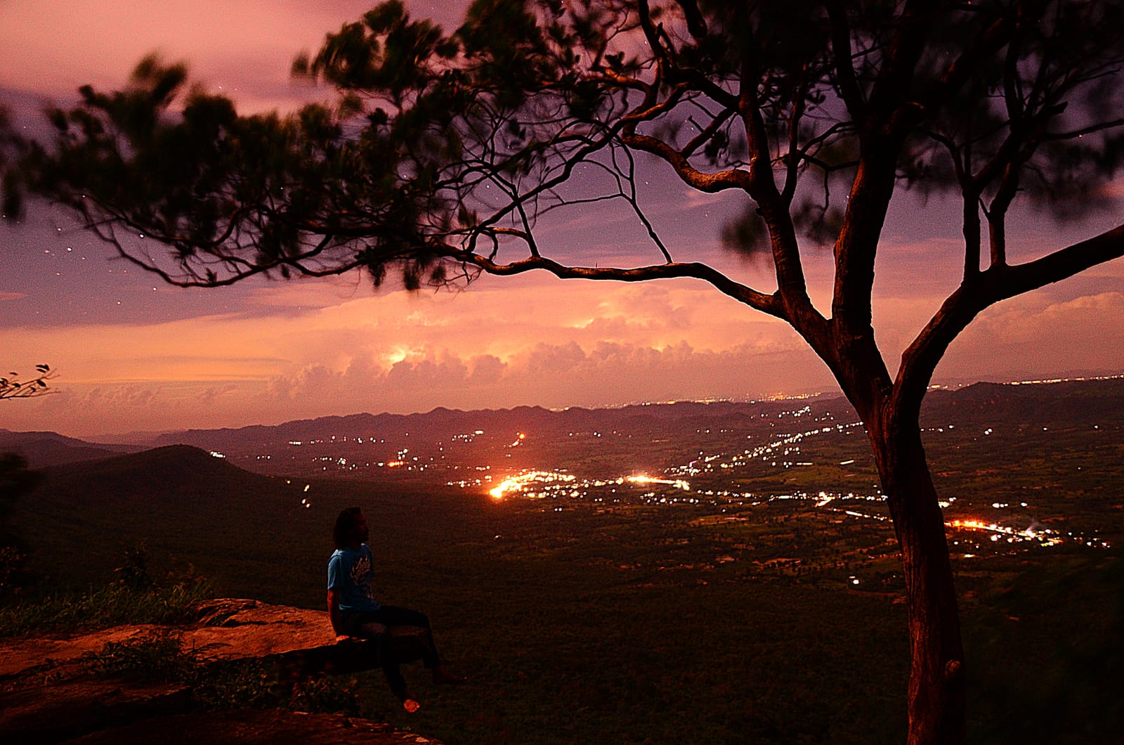
Pha Ham Hod — the jutting rock that's the highlight
Pha Ham Hod is the most photographed spot in Sai Thong. It's a slab of sandstone that sticks out about 1 metre from the cliff face, sitting on the Phang Hoei ridge at roughly 864 metres. Stand on it and look down and you see ranges of mountains stretching to the horizon below you. The name "Pha Ham Hod" comes from the gut-clenching feeling of leaning out to look (it was originally called Pha Nam Phueng). If you're scared of heights, take it slow — but if you're brave enough, this is the shot that makes a lot of people willing to drive a long way for it.
Getting a good photo at Pha Ham Hod
Just after first light, mist often hangs low in the valley, which makes the photos look softer and more layered than later in the morning. To catch that light you'll need to camp in the park or arrive very early — and queue, because it gets busy.
Want more out of Chaiyaphum? Book tours & activities
Booking online ahead on Klook or GetYourGuide is usually cheaper than the gate and skips the queue. Pick only the experiences you actually want — prices and availability are shown live on each site.
Pha Pho Mueang, Pha Daeng, Pha Iang — viewpoints along the ridge
Pha Pho Mueang is a line of sandstone cliffs running about 3 kilometres, around 10 kilometres from the park headquarters, on the western side of the Phang Hoei ridge at roughly 800–908 metres. Walk along the cliff edge and you'll pass several standout viewpoints, each looking out over the mountains below from a slightly different angle. It's great to reach before sunset, when the soft evening light makes the layers of mountains look their best.
- Pha Athit Atsadong — the sunset spot, where you see mountains stacked in layers as the warm evening light comes in
- Pha Suan Sawan — a wide cliff terrace with an open, panoramic view
- Pha Phloen Jai — an easy rest stop to sit and take in the view along the cliff walk
- Pha Daeng · Pha Iang — cliffs where the rock has a distinctive colour and tilt, with wide-open mountain views and nothing in the way, good for landscape shots
The popular route starts from the Pha Pho Mueang campground, follows the cliff edge past Pha Pho Mueang and Pha Ham Hod all the way to the Siam tulip fields, then doubles back the same way. It's a walking trail that isn't very steep but covers a fair distance, so wear comfortable shoes and bring water.
Siam tulip fields — only bloom in the rainy season
The Siam tulip fields are why crowds pour into Sai Thong mid-year. The pinkish-purple flowers (known locally as bua sawan, or "heaven lotus") come up among the green pek grass, with white blooms (bua thep apsorn) mixed in at some spots. Sai Thong has about five large fields scattered across the western side of the Phang Hoei ridge. In the morning a thin mist drapes over them, which makes the fields look like something out of a dream.
Straight talk about the bloom
The Siam tulips only fill the fields and look their best from late June to mid-August, which is the rainy season. Come outside that window and you'll just see grass with no flowers. Before you set off, check the bloom status on the park's page (Sai Thong National Park) every time, because the timing runs early or late from year to year depending on the rain.
Because it's the rainy season, some of the access roads get slippery and muddy — especially the Sap Mongkhon checkpoint route straight up to Field 1, where the road isn't great this time of year. Use a pickup or a high-clearance vehicle for that one. The road from the park headquarters is better and passes Sai Thong Waterfall before heading up to the Pha Pho Mueang side.
Sai Thong Waterfall — a swim stop in the rainy season
Sai Thong Waterfall is near the park headquarters. It's a low fall, about 5 metres high, but the rock shelf is wide — around 80 metres — so when the water runs high in the rainy season it spreads out into a broad curtain. There's a big pool in front you can swim in, which locals call "Wang Sai." It's a good place to stop and cool off before or after hiking up to the cliffs.
Fees, opening hours and where to stay in the park
- Park entry fee — around 40 THB for adults, 20 THB for children, and about 30 THB per car (Thai rate)
- Service zones — Zone 1 is the park headquarters, with bungalows, a campground, restrooms and a visitor centre · Zone 2 is Pha Pho Mueang, about 10 km from headquarters, with a campground near the cliff walk
- Camping / bungalows — book ahead on the national park accommodation site, nps.dnp.go.th. It gets very crowded when the Siam tulips bloom, so reserve in advance
- Park contact — headquarters in Wang Takhe, Nong Bua Rawe, Chaiyaphum, tel. 089-282-3437
Prep before you go
Tulip season is Sai Thong's peak time, so traffic and crowds are normal. Arriving early in the morning is easier. Bring a rain jacket, hiking shoes you don't mind getting muddy, and your own drinking water — there are few shops up on the ridge.
Sai Thong on a 2-day, 1-night trip
If you want both the morning views and the sunset, staying one night is worth more than a day trip. Here's a plan with a comfortable, unhurried pace.
Arrive, swim at the waterfall, catch the sunset
Morning mist, Pha Ham Hod, and the tulip fields
Getting to Sai Thong
Sai Thong is on the western side of Chaiyaphum province. Most people drive themselves, because getting around inside the park means going uphill and some roads turn to mud in the rainy season. A regular car can make it up to the headquarters, but if you're heading in via the Sap Mongkhon checkpoint to Field 1, a pickup or high-clearance vehicle is safer. If you don't have a car, you can also book a local tour package or hire a car with a driver from Chaiyaphum town during the tulip festival.
Want a full Chaiyaphum trip plan, including where to stay and eat?
See the Chaiyaphum travel guide →