🔄 Updated 21 Jun 2026
Plenty of people drive straight through Uthai Thani on the way to somewhere else and miss a lot of good stuff. The nature spots here aren't far apart, so with a little planning you can fit forest, caves and a city view into one trip. We've split it into zones, starting with the easiest place to reach in town and working out to the deeper forest on the Ban Rai–Lan Sak side.
Khao Sakae Krang — a 360° city view right in town
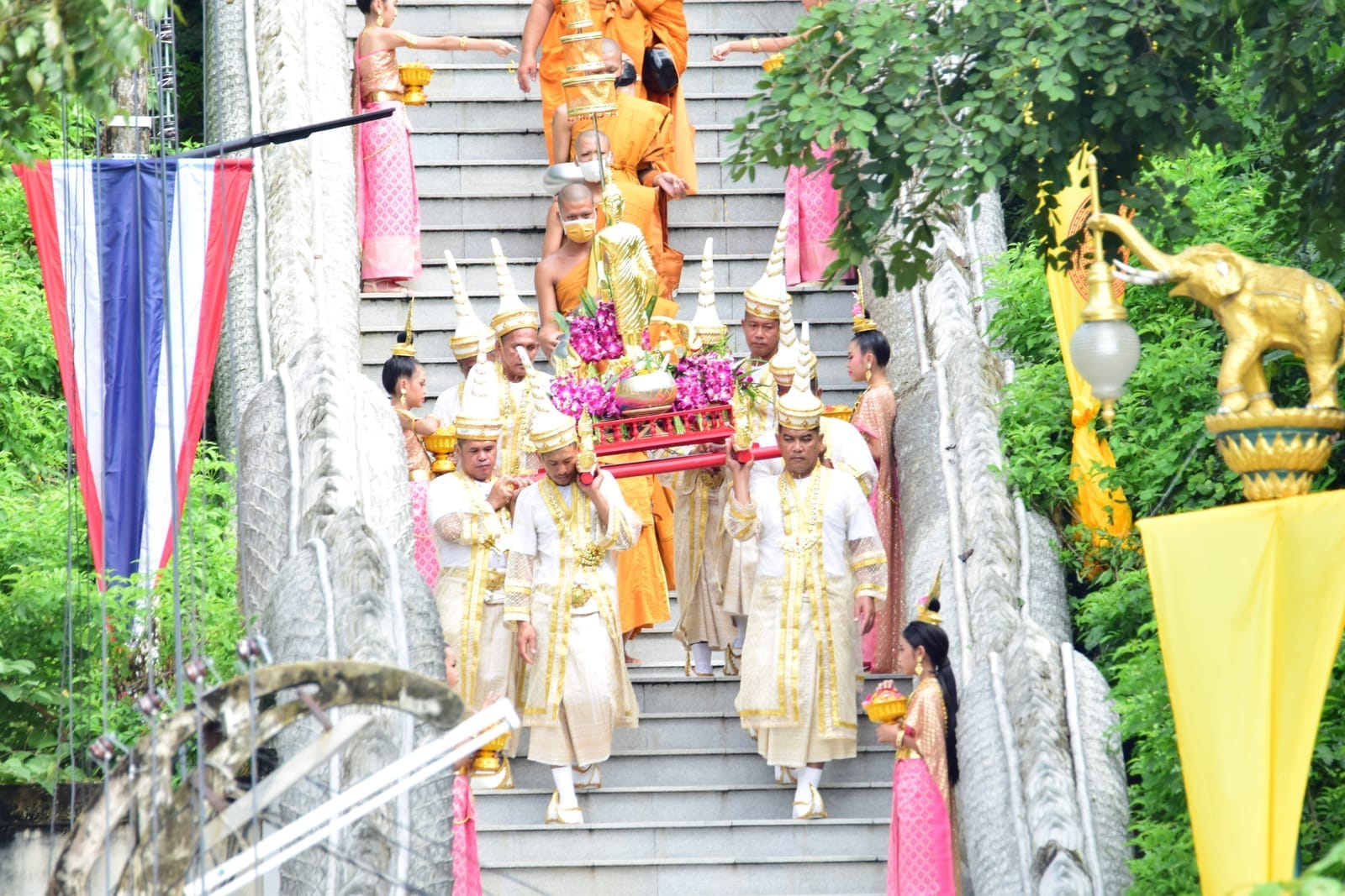
If you only have half a day in town, this is the first stop. Khao Sakae Krang (also called Khao Kaeo) sits inside the municipal area, and on its summit you'll find Wat Sangkat Rattana Khiri and a pavilion enshrining a replica of the Buddha's footprint. From the top you get Uthai Thani town and the Sakae Krang River laid out in a full 360° view.
There are two ways up: walk the 449 steps from the base (this route passes Phra Phuttha Mongkhon, the city's revered Buddha image) or just drive to the summit if you'd rather not climb. At the top there's a row of bells to ring for luck. The busiest time is the Tak Bat Thewo festival after the end of Buddhist Lent, when monks walk down the long staircase in a single file.
Best time to go
Head up in the early morning or near sunset — it's cooler and the light is nicer than at midday. If you're walking the steps, bring water and wear comfortable shoes, because the 449 steps run continuously without many places to sit and rest.
Want more out of Uthai Thani? Book tours & activities
Booking online ahead on Klook or GetYourGuide is usually cheaper than the gate and skips the queue. Pick only the experiences you actually want — prices and availability are shown live on each site.
Hup Pa Tat — walking into a prehistoric forest in a rock valley
Hup Pa Tat is in Thung Na Ngam subdistrict, Lan Sak district, and it's one of the most talked-about spots in Uthai Thani. The entrance takes you through a short, dark cave tunnel (flashlights are handed out at the entrance) before you pop out into a valley ringed by rock cliffs on every side. Inside, fan palms grow thick and light filters down in beams — it feels like you've slipped into a forest from before recorded history.
- The nature trail is about 700 metres long, an easy loop that takes roughly 30–45 minutes. The path is a mix of concrete and packed earth.
- The highlight is the open chamber where light pours down — the most popular photo spot — along with the grove of old fan palms.
- Admission is 20 THB for Thai adults and 10 THB for children; Thai seniors over 60 enter free. Foreign adults pay 200 THB and children 100 THB.
- Hours are daily, 8:30 a.m.–4:00 p.m.
For the best photos
Around 11 a.m.–1 p.m. is when the most light reaches into the valley, so you'll catch those nice light beams. If it's just rained the ground gets slippery — shoes with some tread are the safer bet.
Huai Kha Khaeng — the World Heritage forest you need to understand first
The Huai Kha Khaeng Wildlife Sanctuary is the huge forest on the western side of Uthai Thani (stretching into Ban Rai and Lan Sak districts), listed as a natural World Heritage site together with Thung Yai Naresuan. It's home to rare wildlife like the tiger, and it's where Seub Nakhasathien once worked to protect the forest. You need to understand going in that this isn't a casual stroll-around attraction — it's a conservation area, and only certain parts are open to visitors.
- The Khao Bandai ranger station / sanctuary headquarters has a short nature trail and the Seub Nakhasathien memorial open to visitors — fine for the general public.
- Deeper trails into the forest require advance permission and a ranger to lead you; you can't just wander in on your own.
- Cyber Waterfall (Hin Lat) is a multi-tier waterfall over 30 metres wide, fed by a stream flowing down from the ranges inside Huai Kha Khaeng. The waterfall itself is in Khok Khwai subdistrict, Huai Khot district, and runs strongest from September to early November. The access road is gravel and the last stretch is on foot.
Plan ahead
If you want to enter areas beyond the general public zone, always call and arrange permission with the sanctuary headquarters first. The rules are strict and some trails close seasonally — don't count on walking into the deep forest on a whim.
Ban Rai — hills, coffee farms and cool-season mist
Ban Rai district is on the western side of the province, a hill zone that's cooler than town, with nature, farm cafés and a community market. If you like a low-key mountain atmosphere without the crowds, you can easily spend a whole day here.
Ban Kaen Makrut
The high ground of Ban Rai. In the cool season there's morning mist and a cold-weather flower festival, plus a camping field and community homestays.
Sao Hai (Farmers') Market
A community market open weekends and holidays, selling local food and craft goods, with the simple, laid-back feel of Ban Rai.
Yang Na grove / Pa Mak
A camping field under tall yang na trees and a grove of old-growth forest, shady all day. There's thin mist in the early morning — a good spot to sit, chill and take photos.
Ban Rai also has coffee farms and cafés out in nature scattered around, perfect for a break on the way — after Hup Pa Tat, say, or before heading into the Huai Kha Khaeng zone. If you want to catch the sea of mist at Ban Kaen Makrut, come in the cool season (roughly November to January) and stay overnight so you can reach the viewpoint at dawn.
Khao Phathawi — a limestone hill full of caves and evening bats
If you still have energy and want a nature spot without the crowds, Khao Phathawi is in Taluk Du subdistrict, Thap Than district. It's a limestone ridge about 750 metres long with dozens of caves of all sizes around it. Prehistoric stone tools and human skeletons have been found here. For people who come in the evening, the highlight is the colony of bats streaming out of the cave in a long ribbon at sunset.
Come for the bats
Arrive in the early evening, a bit before sunset, to see the bats pour out of the cave in a steady stream. Find an open spot near the cave mouth and wait quietly — it's a sight you rarely get to see in a big city.
Putting a sensible nature route together
Distances within the province aren't huge, but the Ban Rai–Lan Sak side is in a different direction from town, so a good order keeps you from backtracking. Here's a trip idea.
In town + the Lan Sak side
Ban Rai + Huai Kha Khaeng
About transport
Public transport in the Ban Rai–Lan Sak–Huai Kha Khaeng zone is sparse and doesn't reach everywhere. Having your own car or a rental makes things a lot easier. Fill up the tank before heading into the hill zone, because petrol stations are far apart.
Want a full trip plan for Uthai Thani?
See the Uthai Thani travel guide →