🔄 Updated 21 Jun 2026
Most people who come to Yala head straight for Betong and skip the town entirely. But if you have even half a day, Yala has something you won't find anywhere else in Thailand: a spider-web roundabout city plan that was laid out before the Second World War. This town didn't grow at random — someone sat down and planned the roads and zones in advance. Walk or drive around the central roundabouts and you'll see why people call it the most beautifully planned town in Thailand.
Before you go
Yala sits in Thailand's deep south. Before you actually set off, it's worth taking a few minutes to check the news and any safety or situation advisories from the authorities and local media. The town of Yala is a government quarter where people go about ordinary daily life, but having the latest information makes it easier to plan your route and timing with peace of mind.
Why Yala's city plan is special
The heart of Yala's plan is a set of three concentric roundabouts, with the City Pillar Shrine as the dead centre of the innermost ring, and over 400 roads cutting across and radiating outward like a spider web. Part of the grid is laid out in neat square blocks, like a chessboard. People who've seen aerial shots often compare Yala's nested rings to Paris, and the grid section to Los Angeles. The idea was for the town to grow in an orderly way — wide roads, easy traffic, and a clear sense of which zone was for what, all decided before anything was built.
What people mention most often is that Yala was once ranked the 23rd most orderly and beautifully planned city in the world, and that it's the only province in Thailand to make a list like that. Whichever ranking the number comes from, what you can actually see on the ground is roads that run dead straight and orderly, and rings that widen out one layer at a time in a way that makes sense.
Want more out of Yala? Book tours & activities
Booking online ahead on Klook or GetYourGuide is usually cheaper than the gate and skips the queue. Pick only the experiences you actually want — prices and availability are shown live on each site.
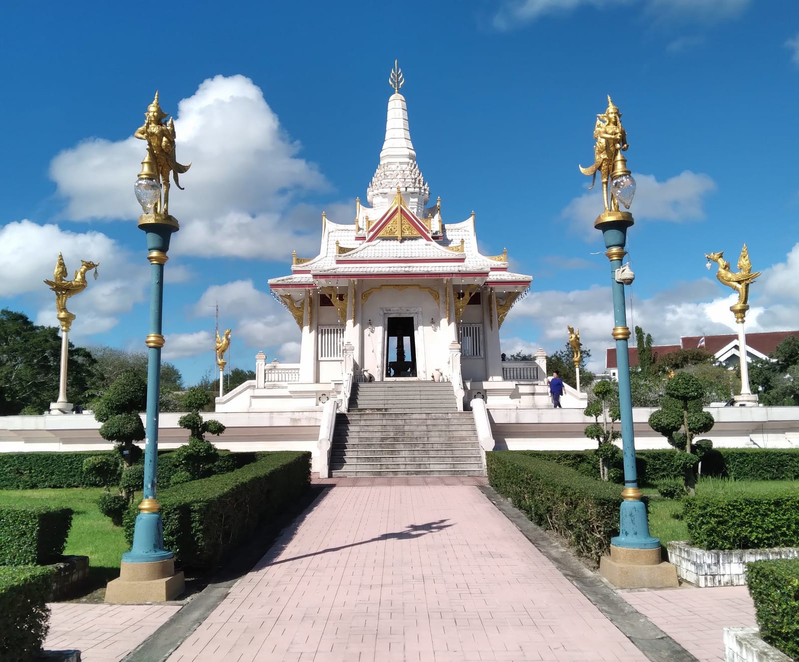
Innermost ring — the City Pillar and the government quarter
Start at the very centre of town. The Yala City Pillar Shrine stands in the middle of the roundabout in front of the Provincial Hall, serving as both the focal point of the city plan and a place of worship for locals. The building is ringed by a central park with a pond, where people come to stroll and feed the birds and fish in the evening — an easy, relaxed atmosphere. The City Pillar Shrine is open for worship roughly 08:00–18:30. This innermost ring is where the main government buildings sit: the Provincial Hall, the provincial court, the district office, and the police station.
- Yala City Pillar Shrine — in the centre of the roundabout in front of the Provincial Hall, the focal point of the whole plan; open roughly 08:00–18:30.
- Suan Khwan Mueang (central park) — a public park near the City Pillar with a pond; an easy evening stroll.
- Yala Provincial Hall — the government building at the heart of the inner ring, the reference point for the entire city plan.
Best time to come
Late afternoon before sunset is the most comfortable time to walk around the City Pillar and the central park — the sun is gentler and locals come out to stroll. If you want to see the orderliness of the streets clearly, try a weekday morning before the traffic builds up; you'll see the dead-straight lines of the roads lined up much more clearly.
The second and third rings — reading the town by its layers
The charm of Yala's plan is that each ring has its own job. Beyond the innermost government ring, the second ring was set aside for civil servants' housing across the various departments, while the third ring holds the hospital, schools, and ordinary homes. Once you know that, try driving outward from the centre and you'll notice the town slowly change face, from government buildings to residential neighbourhoods. This is a town that was planned before it was built, not one that grew however it happened to.
The main streets each have their own name and story too. The ones locals know well are Sirorot Road, the main artery through the centre of town; Phiphitphakdi Road, which runs from Yala railway station to the Clock Tower roundabout; and Sukhayang Road, which continues from the Clock Tower south all the way to Betong. Use these as your compass and you can read the town's story from the railway station, through the Clock Tower roundabout, into the central roundabout.
- Sirorot Road — the main artery through the centre; the Yala Central Mosque sits on this road.
- Phiphitphakdi Road — from Yala railway station to the Clock Tower roundabout; this stretch is the town's old quarter.
- Sukhayang Road — from the Clock Tower heading south, continuing all the way to Betong district.
Stops worth making while you read the city
As you loop around the central roundabouts, there are spots worth stopping at to get out and take photos — both religious sites and corners of the old town. Yala is a multicultural town where Muslim-Malay, Hokkien-Chinese, and Buddhist communities live side by side. When entering religious sites, both mosques and Chinese shrines, dress modestly and follow the etiquette of each place.
Yala City Pillar Shrine
The dead centre of the city plan, in the roundabout in front of the Provincial Hall, ringed by a water garden you can stroll in the evening.
Yala Central Mosque
The provincial mosque on Sirorot Road, the spiritual heart of the Muslim-Malay community. Dress modestly when visiting.
Yala Clock Tower roundabout
One of the town's main roundabouts, where Phiphitphakdi Road meets Sukhayang Road, surrounded by the old-town quarter.
Suan Khwan Mueang
A central public park near the City Pillar with a pond and walking paths — a good spot to rest your legs while sightseeing.
Who designed Yala's city plan
Behind this city plan was Phra Ratthakit Wichan (Sawat Na Nakhon), a former mayor and town leader of Yala in an earlier era. He laid the foundations of the town in Niphong subdistrict, starting with the layout of the first, second, and third roundabout rings, then cutting the main roads — Phiphitphakdi, Sukhayang, and Sirorot — building the framework of the town to grow in an orderly way right from the start. What we see today is the result of that forethought from almost a century ago, not something arranged after the fact.
A small tip
If you want to take in the spider-web plan in full, try pulling up a satellite map on your phone and looking at the town of Yala from above first, then go down and walk it for real. You'll understand how the nested rings and the radiating roads connect to each other. Seeing it from above and walking it down below feel like two completely different things.
An unhurried half-day walking Yala's city plan
Yala's city plan can be done in half a day, making it a good stop before or after the drive to Betong. Below is a rough route you can actually follow, starting from the old quarter near the railway station and working in toward the central roundabout. Adjust the timing to suit yourself.
Old town → central roundabout
An extra afternoon half-day
Getting around town
Yala town doesn't have much public transport, so a private car or rental is the way to go. The streets in town are wide and run dead straight in an orderly grid, so they're easy to drive, though the nested roundabouts can be confusing at first — keep a navigation map open and it's easier. If you're driving on to Betong, fill up and check your car in town first, as petrol stations along the mountain stretch are far apart.
Want a full Yala-Betong trip plan covering the whole province
See the Yala travel guide →