🔄 Updated 21 Jun 2026
Most of Amnat Charoen's terrain is flatland broken up by sandstone hills — the gentle lower slopes at the tail end of the Phu Phan range. So the draw here isn't steep mountains but wide stone plateaus, low hills you can walk up without much effort, and water sources that villagers actually rely on year-round. The nice part is that nearly everything sits just a few kilometres from town, so you can cover several spots in a single day's drive.
Phu Sing-Phu Pha Phueng — rock plateau and sunrise spot
Phu Sing-Phu Pha Phueng Forest Park is the first nature spot that comes to mind for anyone from Amnat Charoen. It sits in Lao Phruan subdistrict, Mueang district — a cluster of sandstone hills around 200-300 metres high at the tail of the Phu Phan range, and the headwaters of the Si Tho stream. The spot people love climbing to is Pha Chuen Warin, a stone plateau on the cliff edge with a wide view of both sunrise and sunset. Late in the rainy season into early winter (November-January), people head up to camp and soak up the cool air, and it gets busy.
- Pha Chuen Warin — the main viewpoint on the rock plateau, good for both sunrise and sunset, with a camping area
- Lan Khwai Tu — a cluster of oddly shaped sandstone formations worn down over ages by wind and water
- Taphap Hin — a wide rock plateau with a boulder shaped like a softshell turtle, a popular photo spot
- Nature trail — winds through dry dipterocarp and mixed deciduous forest, with a fairly gentle gradient
Getting there
From town, take Highway 202 toward Pathum Ratchawongsa district, then turn left onto rural road Or.Jor.3024 and continue about 4 km. Open 8:30am-4:30pm, free entry. If you want to camp overnight or catch the sunrise, it's best to contact the forest park staff ahead of time via their Facebook page, since the camping area is limited.
Want more out of Amnat Charoen? Book tours & activities
Booking online ahead on Klook or GetYourGuide is usually cheaper than the gate and skips the queue. Pick only the experiences you actually want — prices and availability are shown live on each site.
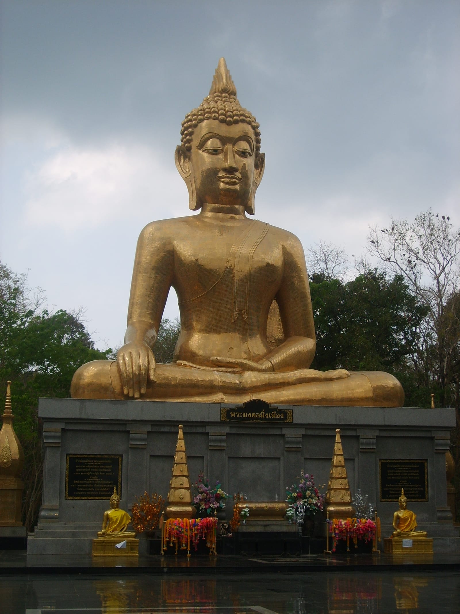
Khao Dan Phra Bat — a stone plateau in a Buddhist park
If you'd rather not go far, Khao Dan Phra Bat is just about 3 km from town, off Highway 212 in Bung subdistrict. It's a natural stone plateau covering nearly 100 rai, rock surfaces interspersed with forest and watercourses. These days it's been turned into a Buddhist park enshrining Phra Mongkhon Ming Mueang (the Big Buddha) in the subduing-Mara posture, with an 11-metre lap width and a height of 20 metres, in a Pala style from northern India. Locals come here to walk for exercise and sit on the rocks every evening.
The appeal here is getting to see the kind of stone-plateau landscape that's typical of the province without having to walk far. It's shaded by trees growing up through the cracks in the rock, ideal for a morning or evening visit when the sun isn't harsh, capped off by paying respects to the Big Buddha all in one place.
Lam Sebai Reservoir — Hua Taphan's freshwater sea
Lam Sebai Reservoir is in Hua Taphan district, a reservoir locals have nicknamed the Lam Sebai freshwater sea. When the water is high you get a sheet of water stretching as far as you can see. In the evenings parents bring their kids to splash around and sit by the reservoir in the breeze — it's more of a relaxing spot for people who live nearby than a destination for outside tourists, so the mood is quiet and laid-back.
Best time to go
Lam Sebai looks best late in the rainy season (September-November) when the water is full, but in some years the surrounding land floods around then. If it's been raining hard, check the water situation first. In the dry season the water drops and you'll see sandbars and tree stumps — a completely different feel.
Huay Si Tho Reservoir — a sandy beach near town
Huay Si Tho Reservoir is a small reservoir the Royal Irrigation Department built to hold water from the Si Tho stream, which has its headwaters at Phu Sing-Phu Pha Phueng. It's not far from town. In the hot season, when the water drops, a white sandy beach appears along the edge and locals come to cool off in the water. There are spots to sit and take in the view around the reservoir, plus a few made-to-order food stalls that open on and off. It's a good stop to pair with Phu Sing on the same route.
Tad Yai Waterfall — the province's biggest waterfall
Tad Yai Waterfall is in Ban Hin Kong, Khok Kong subdistrict, Chanuman district, in the far north of the province. It's formed by the Thom stream flowing over a wide rock shelf — a single-tier waterfall more than 30 metres wide and around 2-3 metres high. The standout feature is that water flows year-round, though it's prettiest and fullest from the rainy season into early winter. Both banks of the falls have sandy beaches to wander along, shaded by forest all around, with a parking area and a concrete path leading in.
Good to know
Chanuman is the farthest of these spots from town (about 50-60 km). If you're heading to Tad Yai Waterfall, plan for half a day and go when the water is high to make it worthwhile. In the dry season, with little water, it can look like just a stream running over rock.
A 2-day, 1-night nature trip
If you've got two full days, here's a route that strings together Amnat Charoen's nature spots at an unhurried pace, using the town as your base.
Rock plateaus near town + the Big Buddha
Up Phu Sing for the sunrise
Before you go
- Your own vehicle is by far the easiest — the nature spots are spread across several districts and public transport barely reaches them
- Check water conditions in the rainy season — Lam Sebai and the reservoirs around town have flooded in heavy-rain years
- Bring water and snacks up the hill — shops on Phu Sing are limited, especially if you go early
- Late rainy season into early winter is the best window — cool air, full waterfalls, and rock plateaus that are pleasant to walk without the heat
Plan a full Amnat Charoen trip — nature, temples and food all in one
See the Amnat Charoen travel guide →