🔄 Updated 21 Jun 2026
Phu Sing-Phu Pha Phueng Forest Park sits in Tambon Sang Nok Tha and Tambon Lao Phruan, Mueang Amnat Charoen district. It's not a polished resort-style attraction with full facilities, but a sandstone hill area roughly 200–300 meters above sea level that the Royal Forest Department has developed into a spot for relaxing and learning about nature. The draw is the wide rock plateaus, boulders carved into strange shapes by erosion, and the clifftop viewpoint. It suits people who like easy hikes, nature photography, and want to escape the bustle and just sit somewhere quiet.
What kind of place is Phu Sing-Phu Pha Phueng?
This is a range of low sandstone hills, not steep enough that you'd need to climb. The top is open rock plateau alternating with deciduous dipterocarp forest, easy to walk all day. The name "Phu Pha Phueng" comes from the cliffs where bee colonies ("phueng") nest in several spots, while "Phu Sing" is a long-standing local name for the hill. People in Amnat Charoen often call it one of the province's high spots with good views. It isn't actually the highest peak, but it's easy to reach and you can see the surrounding fields and forest far into the distance.
- Terrain — sandstone hills, 200–300 meters high, with rock plateaus alternating with deciduous dipterocarp forest on top
- Good for — people who enjoy easy hikes, nature photography, and camping to watch the sunrise
- Not ideal for — anyone after a spot with plenty of shops and lots of activities, because this place is pure nature
Want more out of Amnat Charoen? Book tours & activities
Booking online ahead on Klook or GetYourGuide is usually cheaper than the gate and skips the queue. Pick only the experiences you actually want — prices and availability are shown live on each site.
Highlights inside the forest park
Walking around Phu Sing-Phu Pha Phueng, there are several stops to make, from oddly shaped rock plateaus to clifftop viewpoints. If you cover every spot without rushing, it takes about 3–4 hours. These are the main points people come looking for.
Pha Chuen Warin
The highlight clifftop viewpoint, where you can sit and watch both sunrise and sunset. There's a campground for spending the night in the cool air.
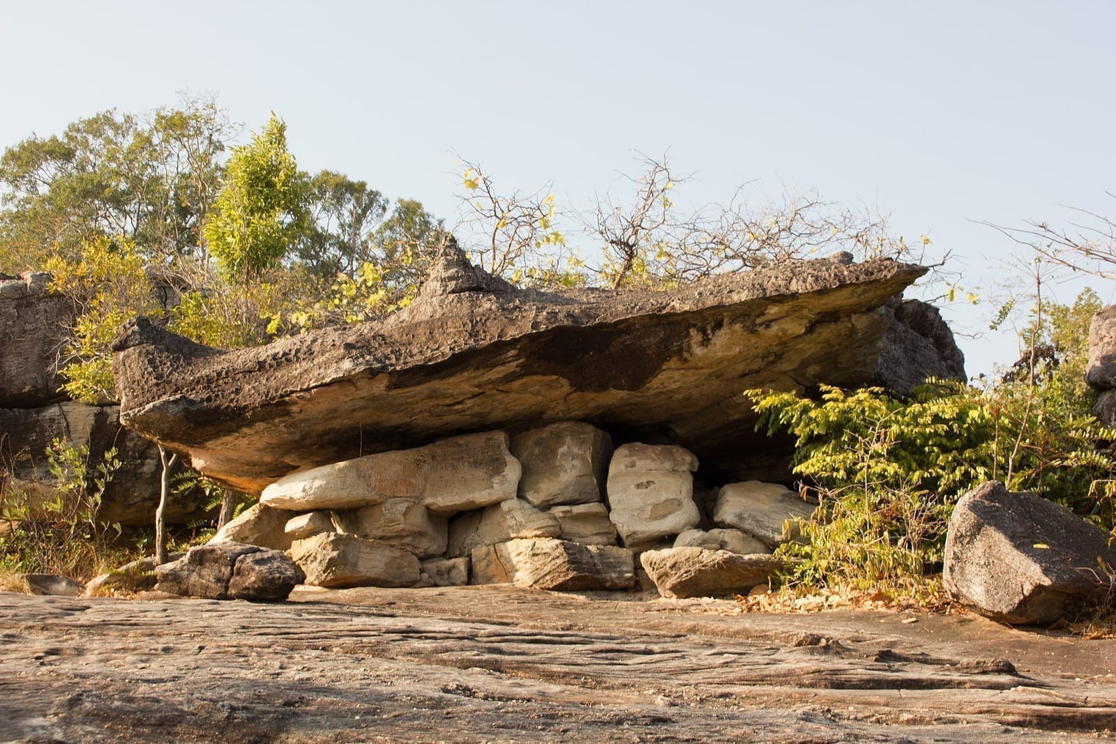
Lan Khwai Tu
A rock plateau with boulders shaped into strange forms by natural erosion. It was once a resting spot for cattle and buffalo traders in the old days.
Taphap Hin
A wide rock plateau shaped like a softshell turtle, a spot for photos and a rest stop along the walk.
Lan Thung Ya
A grassy meadow of about 2 rai where small wildflowers bloom in many colors at the start of the cool season, a pretty photo spot.
There are also small waterfalls within the forest park, like Huai Sai Waterfall and Phaya Nak Waterfall, which carry water in the late rainy season. In the dry season they're usually empty, so don't expect big falls; think of them more as stops along the walk.
The viewpoint — what does it look out over?
A lot of people ask whether you can see the Mekong River from the top of Phu Sing. Honestly, the forest park is in Mueang district and isn't on the riverbank. The view from Pha Chuen Warin is of rice fields, forest, and the low hills of the lower Isan region stretching into the distance, not a direct Mekong River view like you'd get from the riverside. If you specifically want a real Mekong riverside atmosphere, you have to keep driving toward Chanuman district, which is in a different zone entirely. We're making that clear so you don't go and end up disappointed.
When the view is best
Pha Chuen Warin is at its best in the early morning and in the late afternoon near sunset. If you come at the start of the cool season, some days have a thin mist drifting over the fields. Midday sun is hot and the view falls flat, so skip the middle of the day if you're coming for photos.
Which season is best?
The most popular time is the early cool season, roughly November to January, because the weather is pleasantly cool and good for overnight camping, and the grassy meadow has small wildflowers in bloom. From late rains into early cool season the trees are green and the waterfalls have some water. In the dry mid-year months it's hot and the rock plateaus radiate the heat hard, so if you come then, go early or in the late afternoon and bring enough water of your own.
- Nov–Jan (early cool season) — best of all, cool weather, great for camping, with flowers at the grassy meadow
- Sep–Oct (late rains) — lush green, waterfalls have some water, but trails can be slippery
- Mar–May (hot season) — rock plateaus get scorching, waterfalls dry up, go early or late and bring your own water
Camping overnight at Pha Chuen Warin
What sets Phu Sing-Phu Pha Phueng apart from other attractions in town is the campground around Pha Chuen Warin. People who want to wake up and watch the sunrise from the cliff usually stay overnight. There are guesthouses and a forest-park campground here, but facilities are limited, so bring your own food and supplies, and calling to ask and book ahead with the staff is the surer move, especially in the cool season when it gets busy.
Contact and book ahead
For questions about the campground, guesthouses, and trail conditions, contact Phu Sing-Phu Pha Phueng Forest Park at 087-199-4878 or 045-525737. Check every time before you go, because it's a natural area and at certain times it may close or the routes may change.
Before you go — hours, fees, location
- Location — 107 Moo 7, Tambon Sang Nok Tha, Mueang Amnat Charoen district, Amnat Charoen province (extends into Tambon Lao Phruan)
- Hours — roughly 08:30–16:30 daily
- Entry fee — no entry fee
- Time needed to walk — about 3–4 hours to cover the main spots; just Pha Chuen Warin takes less than that
- Phone — 087-199-4878, 045-525737 (for camping / guesthouses / trail conditions)
What to prepare
Wear shoes with good grip because you'll be walking on rock plateaus, bring enough drinking water of your own, and pack sunscreen and a hat, because there's little shade up on the rock. And carry your trash back down with you, since this is a conservation area.
How to get there
From Amnat Charoen town, take Highway 202 heading toward Khemarat district, drive about 16 kilometers, then turn left onto road Or Jor 3024 for about another 4 kilometers and you'll reach the road up to the forest park. Cars can make it up, but parts of the route are dirt road, so drive carefully, especially in the rainy season. Coming from Bangkok, the total distance is about 586 kilometers.
No private vehicle?
Amnat Charoen has no airport and little in-town transport. Phu Sing-Phu Pha Phueng is outside town and no public buses run up there. The easiest option is your own vehicle, a rental car, or a motorbike from town. If you rent a motorbike, brace yourself for the dirt road on the climb up the hill.
Where to go after Phu Sing
Phu Sing-Phu Pha Phueng takes half a day to a full day to see, so it pairs well with other spots in town to fill out the trip. A route that works is to start in town in the morning, then head up the hill in the late afternoon for the sunset, or flip the order however you like.
Phra Mongkhon Ming Muang
The province's large landmark Buddha image, in the Buddhist park in the center of town. Open all day, no entry fee; you can stop to pay respects before heading up the hill.
Temple & viewWat Tham Saeng Phet
A forest temple on a hill with a hilltop hall and a Buddha cave, on the Amnat Charoen-Khemarat road, the same route as Phu Sing.
Mekong riverside, Chanuman district
If you want a real Mekong riverside atmosphere, keep driving toward Chanuman and sit and catch the breeze by the river.
A 1-day plan: Phu Sing + around town
If you have one day and want both temple visits and the hill, try planning it like this. Start in town in the morning before it gets hot, then finish at Pha Chuen Warin in the evening to catch the sunset.
Temples in the morning, the hill in the evening
Camp out and watch the sunrise
Want a full plan for Amnat Charoen's nature spots?
See the Amnat Charoen travel guide →