🔄 Updated 21 Jun 2026
Hat Yai is so well known for food and shopping that plenty of people forget there's nature within easy reach of town. Ton Nga Chang is the first place locals think of when they want to take the kids or some friends for a swim to beat the heat — it's close, you can go in the morning and be back by evening, and the walk is far gentler than many waterfalls in the south.
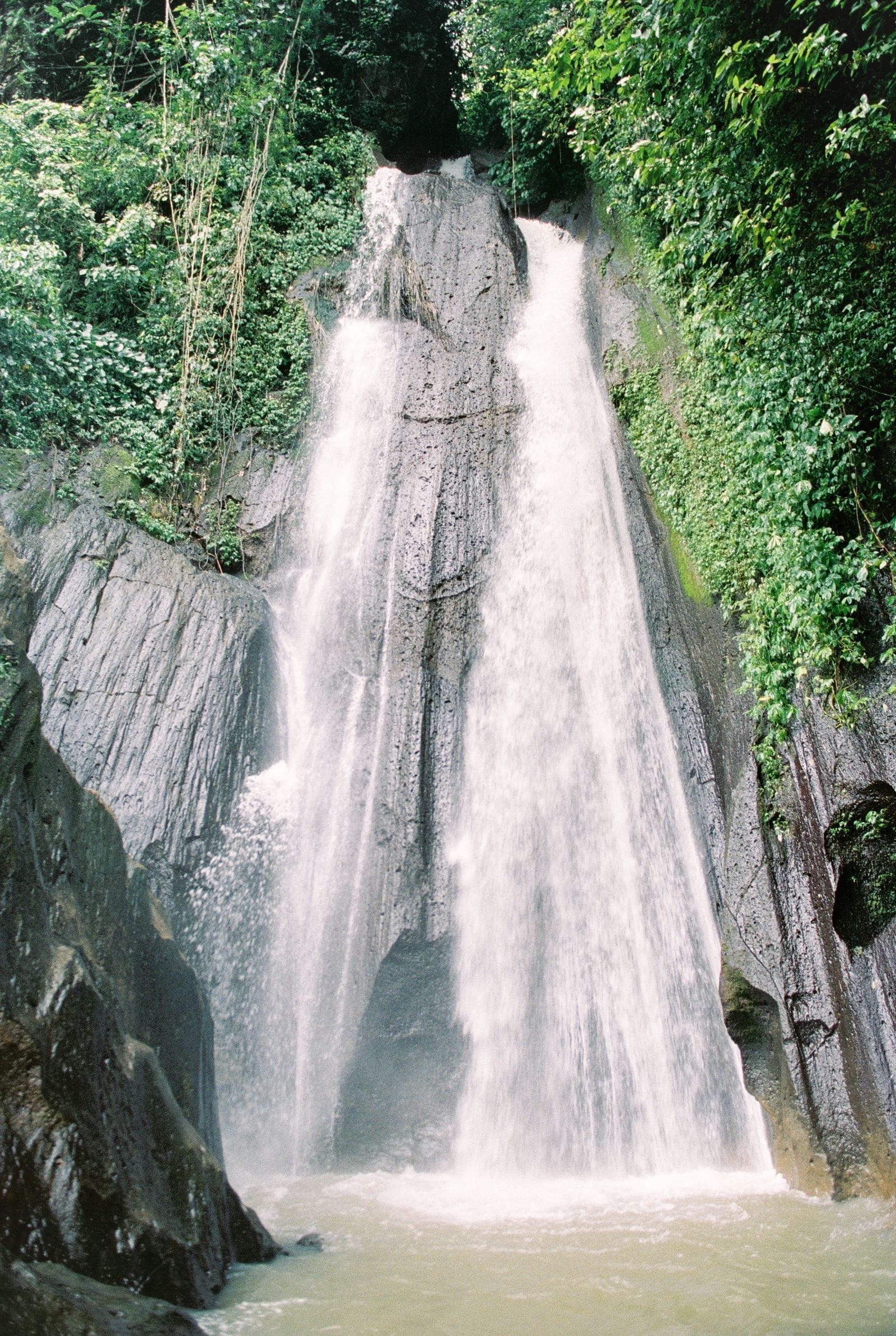
The name "Ton Nga Chang" comes from the third tier, where the water splits into two parallel streams that look like a pair of elephant tusks (nga chang). It's the prettiest and most famous tier. The waterfall sits inside the Ton Nga Chang Wildlife Sanctuary, the headwater forest of the Khao Kaeo range, so you get the falls and cool forest air in one trip.
How many tiers does Ton Nga Chang have, and can you walk up?
There are seven tiers in total, but most visitors don't walk the whole way up. The usual route covers the first three tiers, where the path is easy and the scenery is already worth it. The upper tiers get steep and involve more scrambling, so they're really only for people set on a serious hike.
- Tier 1 — closest to the sanctuary office and the easiest to reach. It's the most popular swimming spot because the pool is wide and easy to get into, which makes it good for families with small kids.
- Tier 2 (Ton Pliw) — about 200 metres on from the first tier. The water drops from a cliff around 20 metres high, splitting into two streams that meet in the pool below. The wide pool here is good for a swim.
- Tier 3 (Ton Nga Chang) — the highlight tier the waterfall is named for, where the two streams fall side by side like elephant tusks. It's about another 15 minutes up from Tier 2, and the path is fairly steep, but the view is worth it.
All told, walking the first three tiers is about 1 kilometre. Taken at an easy pace with no rush, it takes roughly 1–1.5 hours including stops for photos and a swim. The climb up to Tier 3 is the steepest of the three, so shoes with good grip make it far easier than flip-flops.
Hike comfortably
The rocks along the path and around the pools get slippery when wet, especially after rain. Walk slowly, grab a railing or a tree on the steep descents, and don't climb past the barriers into areas the rangers have closed off — some of the cliffs really are dangerous.
Want more out of Hat Yai? Book tours & activities
Booking online ahead on Klook or GetYourGuide is usually cheaper than the gate and skips the queue. Pick only the experiences you actually want — prices and availability are shown live on each site.
How clear and cold is the water, and when is it fullest?
The charm of Ton Nga Chang is water that stays clear and cold all year, because it flows down fresh from the Khao Kaeo headwaters. In the lower pools you can see the rocky bottom clearly, and a swim here is refreshing without needing to head to the sea.
The water level follows the seasons closely. From late rainy season into early cool season (roughly October–January) the flow is highest and the waterfall is at its best, with the cliffs running full and dramatic. In the dry months (March–May) the flow drops and some tiers thin out to a trickle, though you can still swim in the pools. If you want to see the falls running full, aim for just after the rains.
Watch out after heavy rain
If heavy rain hits while you're up on the mountain, get out of the pool and away from the stream straight away — flash floods come down faster and harder than you'd expect. Don't push your luck swimming when the water turns muddy or unusually fast.
How to get there from Hat Yai
The waterfall is about 26 kilometres from central Hat Yai, a drive of roughly 30–45 minutes depending on traffic. The main route is along Phetkasem Road on the Hat Yai–Rattaphum line; around the 13-kilometre mark you turn left into the Ton Nga Chang Wildlife Sanctuary and follow the road another 13 kilometres or so to the office.
Drive / rent a car
The easiest option. Just drop a pin on 'Ton Nga Chang Waterfall' in Google Maps and follow it; there's a car park at the sanctuary office. Car rentals in Hat Yai start at around 600–900 THB per day.
Private car / tuk-tuk
Hire a car from town for the round trip, roughly 300–400 THB and up per trip depending on how you bargain and the waiting time. A good choice if you're not driving yourself.
Songthaew
Songthaews run from the Hat Yai municipal fresh market area. The fare is cheap, but they don't run often and you may have to walk part of the way. Check the schedule with locals before you go.
If you're going without your own car, the route many people choose is to hire a car for the round trip and arrange a pickup time, since cars are harder to find heading back in the late afternoon than on the way out. Tell the driver clearly how many hours you plan to spend swimming so there's no guesswork.
Entry fees, opening hours and what to know
- Opening hours — roughly 08:00–17:00 (sometimes listed until 18:00). Go from morning to early afternoon so you have time to walk and swim before it closes.
- Entry fee — around 20 THB for adults and 10 THB for children, with car parking about 30 THB (rates may change, so bring cash).
- Call ahead — the Ton Nga Chang Wildlife Sanctuary office can be reached at 0-7489-4804. If you're going in the rainy season, ask about the water level and the trail conditions first.
- Facilities — there's a car park and toilets at the sanctuary office, plus a few small snack stalls but not many. Bringing your own drinking water and food is the safer bet.
Pack out your trash
This is a wildlife sanctuary and a headwater forest. Carry your rubbish back out, don't drop anything in the stream, and don't use soap or shampoo in the waterfall, so the water stays this clear for the people who come after you.
Making a full day of Ton Nga Chang
Being so close, Ton Nga Chang works as either a half-day or a full-day trip. Try treating it as an easy nature outing and head back into town for dinner.
Morning at the falls, back in town by midday
Nature in the morning, food in the evening
Plan a full nature-and-waterfall trip around Hat Yai
See the Hat Yai nature itinerary →