🔄 Updated 21 Jun 2026
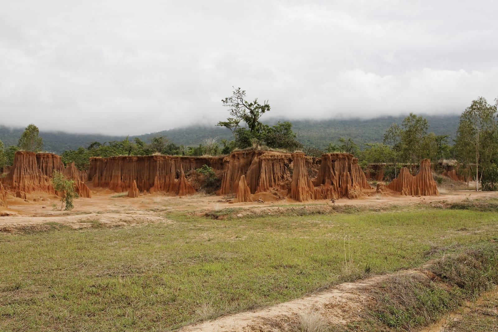
Lalu is a landscape shaped by years of rain eroding the earth. The softer soil washes away and leaves behind harder cores standing as tall pillars, with some spots forming walls and steep cliffs that look like ruined castles or an ancient city falling apart. The word Lalu comes from the local Khmer dialect and means to break through or to pass through, which fits the way water has bored hollows and gaps you can walk through.
What's interesting is that Lalu never sits still. Every year after the rainy season the shapes keep changing: some pillars collapse, others get carved deeper. Someone who came years ago and someone visiting this year won't see exactly the same thing. It's nature still very much at work.
What Is Lalu and How Did It Form?
Lalu sits at Ban Noen Kham and Ban Khlong Yang in Tap Rat subdistrict, Ta Phraya district. It's a flat area with a layer of sandy soil mixed with clay. When heavy rain falls year after year, the water erodes the softer soil away and leaves the harder cores standing up as pillars, some several meters tall, lined up across a wide area. When the early-morning or late-afternoon light catches them, the brown-orange surface turns golden, and that's the moment many people come to photograph.
- All kinds of shapes — single pillars, long walls, steep cliffs, and hollows you can pass through, spread across more than 2,000 rai
- Changes every year — each year's rain erodes differently, so the shapes are never quite the same
- Like Phae Mueang Phi — it forms much like Phae Mueang Phi in Phrae, but Lalu covers a wider area and you have to ride in to see it
Want more out of Sa Kaeo? Book tours & activities
Booking online ahead on Klook or GetYourGuide is usually cheaper than the gate and skips the queue. Pick only the experiences you actually want — prices and availability are shown live on each site.
Touring by E-taen Tractor — Why You Have To Ride
The Lalu area is huge and the tracks are rough dirt, so sedans and private cars can't get in. The local community runs e-taen tractors (modified farm tractors with a flatbed seating area) to take you around the different spots. The drivers are locals who know which spots are prettiest, where the photos work, and they'll stop and let you get off to walk around at various points. Along the way you also see village life — rice paddies, chili fields, and the locals' fish ponds.
- Tractor fare — about 200 THB per vehicle, seating up to 6 people (some times of year or some drivers charge 250 THB, so ask at the visitor center first)
- Opening hours — roughly 08:00–18:00
- Time needed — one loop runs about 1–1.5 hours, depending on how long you stop to take photos
- Extra activities — at certain times there's also cycling around the community to choose from
A tip on the tractor
If there are only a few of you, try teaming up with another group of visitors at the visitor center to split the fare. It's better value, since the charge is per vehicle, not per person.
Best Time to Go — When Does It Look Its Best?
Timing matters a lot at Lalu, because the area is open ground in full sun with no shade. Midday the sun is harsh and it gets very hot, so you tire out fast and the light is so flat that photos don't come out well. Your best move is to skip the middle of the day entirely.
- Morning 08:00–10:00 — still cool, and the slanting light turns the earth pillars a soft gold, great for photos
- Evening 16:00–18:00 — the sun softens and the soil takes on warmer tones; this is many people's favorite window
- Avoid midday 11:00–15:00 — very hot with harsh light; watch out for sunburn and heatstroke
As for the season, the sweet spot is from the late-rain, early-cool period through the cool season, roughly November to February, when the dirt tracks are dry and easy to walk and the weather is just right. In the full rainy season the tracks turn muddy and slippery, and the e-taen tractors sometimes struggle to get in, so call ahead and check with the visitor center before you set out.
Check before you go
Lalu is deep and far out, and if there's been heavy rain beforehand the track conditions can change. It's worth phoning the Khlong Yang tourist service center to ask whether they're open for visitors as usual that day.
How To Get to Lalu
Lalu is in Ta Phraya district, the northernmost district of Sa Kaeo, right on the Cambodian border. It's a fair distance from Sa Kaeo town, and there's no public transport that reaches it directly. The easiest way is to drive yourself or rent a car.
- From Bangkok — take Highway 33 (Suwannason) toward Sa Kaeo–Aranyaprathet, then branch north to Ta Phraya, about 280–300 km in total, roughly 4–4.5 hours
- From Sa Kaeo town — drive north toward Ta Phraya district, following the signs to Lalu / Ban Khlong Yang
- No private car — you'll need to charter a vehicle from Sa Kaeo town or Aranyaprathet, since scheduled buses don't reach the site
On the border situation — Ta Phraya is a district bordering Cambodia. Lalu itself is within a normal tourist zone and doesn't require crossing the border. But if you plan to continue toward the border area or cross into Cambodia, check the current border situation and the documents you'll need with the relevant authorities before you travel, since the rules and crossing points can change from time to time.
What To Prepare
Sun protection ready
It's open ground with no shade, so sunscreen, a hat, sunglasses, and a packable umbrella all help a lot, especially if you can't avoid the midday hours.
Drinking water
Bring your own water, since there aren't many shops to stop and buy from while you're touring.
Walking shoes
The tracks are rough dirt and you'll get off to walk in places, so sneakers or shoes you walk comfortably in beat sandals.
Cash
The tractor fare and food in the community are mostly cash only, so carry cash with you.
For food nearby, there's enough to tide you over in the Khlong Yang community and at the Ta Phraya district market, mostly made-to-order dishes and local fare. If you want a proper meal, plan to stop in Sa Kaeo town or Aranyaprathet, where there's more choice.
Plan more of your Sa Kaeo trip — where to stay, eat, and explore around the province
See the Sa Kaeo travel guide →