🔄 Updated 21 Jun 2026
Before we start, honest heads-up: you really need your own car or a rental to do this route smoothly. The 1256 sky road from Pua to Doi Phu Kha and Bo Kluea runs about 25 km, but it's mountain road with curves climbing and dropping the whole way — driven realistically it takes nearly 2 hours if you stop at the viewpoints. There isn't much traffic, and both sides of the road are mountains and fog. If you get carsick easily, bring something for it, and fill up the tank in Pua, because fuel stations up in the hills are scarce.
Who this trip is for
- People who love driving for the view — the 1256 sky road and the Santi Suk–Bo Kluea stretch are the stars of this trip, and they're more fun behind your own wheel.
- Fog chasers and photographers — Pua, Sapan and Bo Kluea get morning fog in the late-rain, early-cool season, and getting up early is well worth it.
- Anyone who wants to slow down — this plan isn't packed. It leans toward sitting at cafés, walking through villages and watching the salt-making way of life, rather than ticking off stops.
When it's at its best
The late-rain, early-cool window — roughly October to February — is peak. The rice paddies are green, then turn gold around October, the morning fog is thick and the air is cool. In the full rainy season the mountain roads get slippery and the fog can drop until the views close in, so drive carefully then.
🎟️Book the activities in your Nan trip ahead
Booking online ahead on Klook or GetYourGuide is usually cheaper than the gate and skips the queue. Pick only the experiences you actually want — prices and availability are shown live on each site.
🎟️ See all Nan tours & activities (Klook) Day 1 — Nan town, up to Pua, paddy-side cafés
Day 1
Nan → Pua
Morning
Leave Nan town and head north to Pua (about 60 km via Highway 1080)An easy drive of just over an hour, with coffee stops along the way if you like. Leave town mid-morning and you'll reach Pua right around noon.
Midday
Arrive in Pua, grab lunch in town, then stop at Wat Sri Mongkhon (Wat Kong)Wat Sri Mongkhon has a terrace behind the temple looking out over rice fields with the Doi Phu Kha range as a backdrop — one of Pua's most popular photo spots, and a pleasant place to wander.
Afternoon
Sit at Ban Tai Lue coffee shop with views over the rice fieldsBan Tai Lue coffee shop in Sila Laeng is a paddy-side café done up in Tai Lue style, with a wooden bridge and bright woven textiles. Coffee runs around 100 THB, and the view across the rice fields and mountains makes it a near-mandatory stop for anyone visiting Pua.
Evening
Head up to Wat Phuket for the evening light, then check in around PuaWat Phuket sits on a rise looking down over wide rice fields and the Doi Phu Kha range. From September to October the paddies turn green and gold and look their best. Places to stay in Pua range from paddy-side homestays to resorts with mountain views.
Day 2 — The 1256 sky road over Doi Phu Kha to Bo Kluea
Day 2
Pua → Doi Phu Kha → Bo Kluea → Sapan
Morning
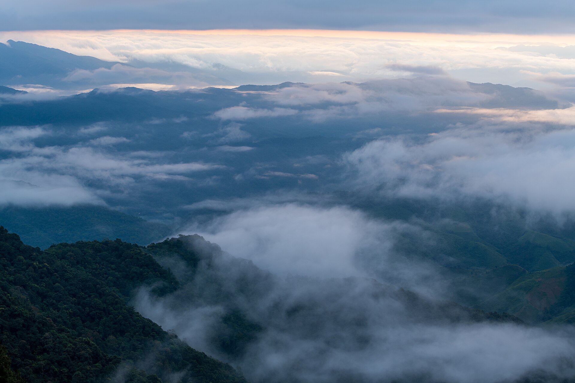
Catch the morning fog in Pua, fill up the tank, then take Route 1256 up Doi Phu KhaFill up in Pua before climbing, because fuel stations on the 1256 are very few. Setting off early also means catching the thin fog up on the mountain.
Late morning
Stop at Doi Phu Kha National Park and the 1715 viewpointThe 1715 viewpoint (1,715 m elevation) is a pull-over photo stop with the full Doi Phu Kha range in front of you. In January and February the Chomphu Phu Kha trees near the park headquarters bloom pink — a rare tree found only in this area.
Midday
Drop down to Bo Kluea and see the mountain rock-salt wellsThe Bo Kluea salt wells are a mountaintop salt source that's been worked for over 800 years. Villagers draw brine from the wells and boil it down into salt — you can watch up close, and there's salt and local souvenirs for sale. You can find lunch in Bo Kluea town.
Afternoon
Drive on to Sapan village and check in beside the Mang streamSapan is a small village in the middle of a valley — quiet, with cool air. Most lodging is riverside homestays, from around 500–900 THB/night. It gets busy in the cool season, so book ahead.
Evening
Walk the Sapan bridge for the evening light, then have dinner in the villageThe Sapan bridge crosses the Mang stream at the village entrance, with the water and mountain ridges as a backdrop — the main check-in spot in Sapan.
Day 3 — Sapan morning fog, a waterfall, then loop back
Day 3
Sapan → Sapan Waterfall → back
Early morning
Wake up to the morning fog in the Sapan valley, coffee by the streamSapan's real charm is in the early morning — fog fills the whole valley, and sitting at a streamside café watching it slowly lift is well worth the early start.
Late morning
Walk out to Sapan WaterfallSapan Waterfall is near the village, an easy walk in. It flows for most of the year, and you can swim or just sit and rest. In the rainy season the water runs strong, so watch for slippery rocks.
Midday–afternoon
Leave Sapan and loop back to Nan townYou have a choice on the way back: retrace Route 1256 through Pua, or take Route 1081 down via Santi Suk–Bo Kluea. Allow 3–4 hours of driving to reach Nan town. Leave early afternoon and you'll be back before dark.
A few things before you go
- Fill up in Pua — fuel stations on the 1256 and in Bo Kluea are few, so topping off the tank in Pua gives you peace of mind.
- Book lodging ahead — Sapan and Bo Kluea have few rooms and fill up fast in the cool season, so book at least 2–3 weeks out.
- Pack warm clothes — nights on Doi Phu Kha and in the Sapan valley get cold, especially November to February.
- Phone signal comes and goes — some spots around Sapan and Bo Kluea have weak signal, so download offline maps before you go.
If you have more time
With 4 days, add another night in Pua so you can hit all the cafés before heading up the mountain, or add the Route 3 sky road (the one shaped like a number 3 on the road) on the Santi Suk–Bo Kluea stretch. No need to cram everything into 3 days.