🔄 Updated 21 Jun 2026
Nan sits in a valley in Thailand's far northeast, a little farther out than Chiang Mai. The trade-off is a quiet town, seas of morning mist, and some of the prettiest mountain roads in the country. A few things decide whether the trip lands or flops — let's run through them one by one.
When Is the Best Time to Visit Nan?
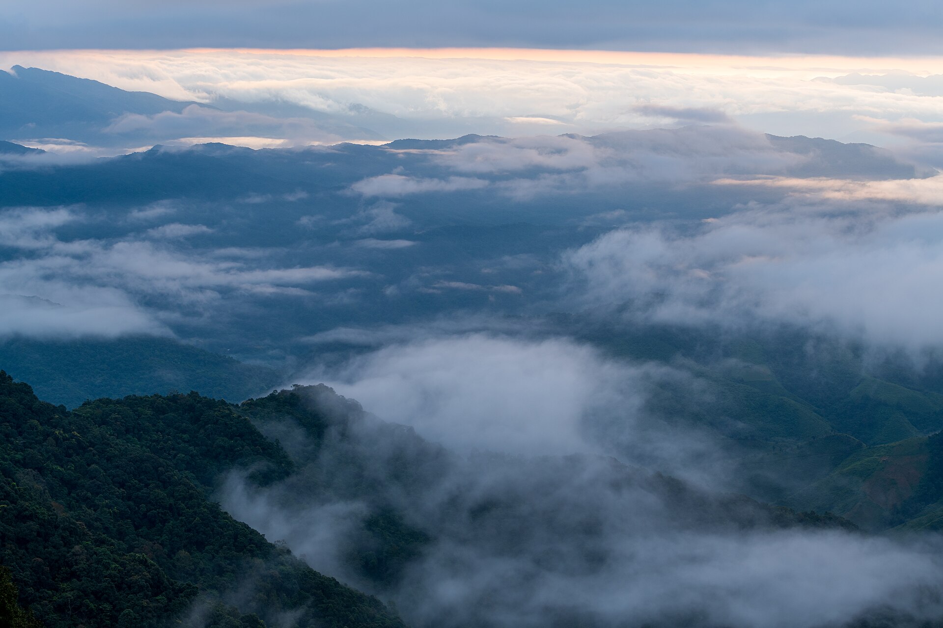
The whole trip hinges on picking the right month, because the mountain views and the sea of mist come down to the weather alone. Short version: November to February is best, and avoid March to April if you possibly can.
- Oct–early Nov — the tail of the rains into early cool season. Clear skies, the rice fields still green-gold, a high chance of morning mist, and crowds still thin. It's gorgeous now, though some days still catch a passing shower.
- Dec–Jan — peak cool season. Genuinely cold, and up on Doi Phu Kha, Bo Kluea, and Sapan the early mornings can drop into single digits. December gives you the best odds of mist blanketing the town — but it's packed, and rooms get pricey and book out fast.
- Feb — still pleasantly cool early in the month, but toward the end the stubble-burning smoke creeps in and the views start to turn hazy.
- Mar–Apr — burning season. Thick PM2.5, the mountains lost behind the smoke, and hot weather. Not the time to come if your plan is to shoot the scenery.
- May–Sep — the rainy season. Lush and green, beautiful rice fields, and mist drifting over the Skyroad — but it rains often and the mountain roads get slick, so check the forecast before you go.
Check the haze before you book
If you really can't dodge the burning months, check Nan's daily PM2.5 on the IQAir app or the GISTDA website before you lock in your dates. Some years the fires come early, by mid-February; other years they drag on into May.
How to Get to Nan
You can reach Nan by air, by coach, or by driving yourself — pick based on your budget and style. The figures below are rough and shift with the season and any promotions.
Flying — direct to Nan Nakhon (NNT)
The fastest option, about 1 hr 20 min from Don Mueang to Nan. Nok Air and Thai AirAsia fly direct into Nan Nakhon Airport, which sits right by town, so you can grab a taxi straight in. Good if your leave days are tight.
Coach — Nakhonchai Air / Sombat Tour
The cheapest option if you're not in a hurry. Board at Mo Chit and ride overnight, around 9–11 hours, waking up in Nan. Nakhonchai Air runs comfortable air-con coaches with seats you can sleep in — ideal for budget travelers who can sleep on the bus.
Driving yourself
The most freedom and the best value if there are a few of you. Bangkok to Nan is about 660–680 km, roughly 8–9 hours with rest stops. The upside is you've already got a car to keep exploring the mountains — no need to rent again. Ideal if you're planning to drive Route 1256 anyway.
Fly in and you'll still need a car
Nan's best spots — Pua, Bo Kluea, Sapan, Route 1256 — are all outside town. If you fly in, rent a car at the airport or in town. There are plenty of rental shops in Nan town: sedans/eco-cars start around THB 900–1,200 a day, SUVs from about THB 1,500 up. Book ahead in the cool season because cars sell out fast.
Daily Budget — How Much to Set Aside
Nan is still an affordable place to travel — rooms and food cost less than in the big tourist cities. These figures are per person, per day (not counting your transport to Nan or car rental), and you can adjust to your style.
- On a budget, THB 800–1,200/day — guesthouses or hostels in the old town, eating at rice-and-curry shops and khao soi joints, free temple and café hopping.
- Comfortable, THB 1,500–2,500/day — boutique hotels and resorts, nicer cafés, fuel for the mountain drives, a few souvenirs. A sweet spot for most trips.
- Treat yourself, THB 3,000+/day — mountain-view resorts around Pua or Sapan, a special meal, rice-field cafés, plus admission fees and tips.
Cool-season rooms book up very early
December and January are peak season, and the scenic resorts around Pua and Sapan fill up months ahead, with prices nudging above normal. If you've got your eye on a room with a good view, book it the moment your leave dates are confirmed.
Want a mountain-view room in a good spot? We've shortlisted them.
See the 10 best Nan hotels →What to Wear and What to Pack
A lot of people slip up assuming "the North = cold all day." In reality, a Nan winter is hot and sunny by day but genuinely cold before dawn and at night up on the mountains — a 15–20°C swing in a single day. So dress in layers you can peel off and pull back on.
- One warm jacket or coat — essential if you're staying up on the mountains (Pua, Bo Kluea, Sapan, Phu Kha), where the early mornings get bitter. If you're sticking to town, a thick long-sleeve top is enough.
- Short-sleeve / light tops — more comfortable under the strong midday sun, and they layer well so you can shed the outer jacket.
- Sneakers / comfortable walking shoes — for temples, markets, and a few viewpoints with uneven ground.
- Hat, sunglasses, sunscreen — the mountain sun is stronger than you'd think, and your eyes tire on long drives.
- Scarf / light gloves — genuinely helpful if you come in December–January and plan to wait out for the dawn mist.
- A dust mask — handy if you arrive in late cool season when the smoke starts.
SIMs and Mobile Signal on the Mountains
In Nan town every network works fine, with smooth 4G/5G. The trouble is on the mountain routes — Route 1256 (Pua–Bo Kluea) and the Sapan–Doi Phu Kha area have dead-spot stretches where the signal drops out, especially deep in the valleys.
- AIS tends to have the best mountain coverage. If you're picking a single SIM for the highlands, it's the safer bet.
- Download offline maps in Google Maps before heading up, so navigation keeps working through the no-signal patches.
- Mountain homestays and resorts mostly have Wi-Fi, but it's slower than in town, and at some places the power and internet can flicker during rain or outages.
- Tell folks back home that you may be out of contact for an hour or so while driving Route 1256, so no one worries.
Driving Nan's Mountain Roads — What to Watch For
Skyroad 1256 (Pua–Bo Kluea) is the prettiest route in Nan, running along the ridgeline with views opening on both sides — but it's also a road with plenty of curves and some genuinely steep grades. First-timers need to stay sharp. Here's what to keep in mind.
- Lots of curves, one after another — Route 1256 climbs and drops through hundreds of bends. Anyone who gets carsick should take motion-sickness pills first. Drive slow, and use a low gear on the descents to help braking and avoid sliding.
- Set off early — drive mid-morning when the sky is clear and the light is good, and you'll dodge the heavy mist or afternoon rain that wrecks visibility.
- Fill up before heading up — gas stations on Route 1256 are few and far between. Top off the tank at Pua or Bo Kluea before the long stretch.
- Avoid driving at night — the mountain roads have no lights, the hairpins are sharp, and animals can cross. Don't drive in the dark unless you have to.
- Check the brakes and tires — if you've rented, test the brakes around town first. The long descents lean on them hard.
- Slick roads in the wet — May–Sep, some stretches grow moss, so slow down into the corners and watch for sliding.
Photo stops along the way
Route 1256 has viewpoints at intervals. If you want to pull over for photos, find a wide shoulder, stop clear of the bends, and put your hazards on. Never stop mid-curve — oncoming cars won't see you.
Ready to roll? Dive into the full Nan trip plan next.
Open the Nan travel guide →