🔄 Updated 21 Jun 2026
Always check before you go
Pha Mo I Daeng and Khao Phra Wihan National Park sit right on the Thai-Cambodian border. When tensions rise along the border, the park announces temporary or indefinite closures of its sites for safety, and it has been closed for long stretches in the past due to border clashes. Before every trip, call the park office (0 4582 6045) or check the Khao Phra Wihan National Park Facebook page for announcements, and always have a backup plan.
The short version: Pha Mo I Daeng is a red sandstone cliff about 300 metres long that forms a natural divide between Thailand and Cambodia. The cliff is steep, and below it the Cambodian plains roll out to the horizon. That's why it's become a viewpoint and sunrise spot that Sisaket locals are proud of. Walk along the cliff edge and you reach the real historical draw: rock carvings set into the stone for a thousand years, and the path once used to climb up to the Preah Vihear temple.
Where is Pha Mo I Daeng, and why do people come?
Pha Mo I Daeng is in Sao Thong Chai sub-district, Kantharalak District, in the far south of Sisaket Province. It's looked after by Khao Phra Wihan National Park and forms part of the Dangrek mountain range that marks the border between Thailand and Cambodia. The appeal here is standing on a high cliff edge and looking across the border line to see another country's land with your own eyes — an experience you can only get in a handful of places in Thailand.
The other reason people make the trip is the layered history. Pha Mo I Daeng was once a spot where the Thai flag was raised, up until 1962, when the International Court of Justice ruled that the Preah Vihear temple belonged to Cambodia. Today Pha Mo I Daeng is a viewpoint, a place to learn, and a spot where many Thais come to stand and look out at the Preah Vihear temple from a distance.
Want more out of Sisaket? Book tours & activities
Booking online ahead on Klook or GetYourGuide is usually cheaper than the gate and skips the queue. Pick only the experiences you actually want — prices and availability are shown live on each site.
Highlights at Pha Mo I Daeng
The cliff-edge viewpoint
A broad rock platform along the cliff face, looking down over the Cambodian plains stretching away. In the early morning, if the weather cooperates, you'll see a sea of fog drifting below. It's a popular sunrise spot in Kantharalak.
The bas-relief carving
Figures carved into the cliff face below the edge, depicting people in Khmer-style dress, thought to be over a thousand years old. You walk down the stairs to see them up close — solid evidence of ancient Khmer civilisation.
The twin stupas
Two red sandstone structures standing side by side, not far from the cliff edge. They make for a photo stop and a trace of the old beliefs that remain at Pha Mo I Daeng.
The path to Preah Vihear
Pha Mo I Daeng was the starting point of the old route up to the Preah Vihear temple. Climbing the temple now depends on the border situation, but this is still the spot where people stand and look out at it from the Thai side.
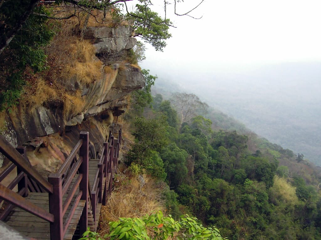
The bas-relief carving — the real thing you shouldn't skip
If you come all the way to Pha Mo I Daeng and don't go down to see the bas-relief carving, you've missed the heart of the place. It's carved into the rock wall below the cliff edge — you have to walk down the stairs running along the cliff face to reach it. The carving shows three figures in Khmer-style dress; archaeologists believe they are Hindu deities, the work of craftsmen from the height of Khmer power, a thousand years old.
- You have to walk down the stairs — the carving sits below the cliff edge, and the way down is a staircase running along the cliff face. If you're afraid of heights you may need to steady yourself, but there's a handrail the whole way.
- Wear shoes with good grip — some of the rock is slippery, especially after rain or in the morning when there's dew. Sneakers or hiking shoes are safer than sandals.
- Don't write on or touch the carving — it's a thousand-year-old historical relic. Take photos, but don't touch or damage it. Leave it for the next generation to see.
The best time to visit
Pha Mo I Daeng is at its best in the early cool season, roughly September to November. The air turns cooler and humidity builds up just right, so there's a chance of seeing a sea of fog blanketing the Cambodian plains in the pre-dawn hours. If you're set on catching the fog or the sunrise, you need to arrive before the sky lightens — which means staying overnight around Kantharalak or in Sisaket town and heading out very early.
- Early cool season (Sep–Nov) — your best shot at morning fog, with cool, pleasant weather. This is when most people come.
- Cool season (Dec–Feb) — dry and cool with clear skies and sharp views. Good if you're after wide views more than fog.
- Hot season (Mar–May) — strong sun and serious heat on the open rock platform. Come early and leave before the sun gets harsh, and bring water and a hat.
About the sea of fog — straight talk
The sea of fog isn't there every day; it depends on the humidity and weather that morning. Some mornings you'll arrive to clear skies and no fog at all. Even if there's no fog, you still get the wide cliff-edge view and the sunrise. Don't set your hopes on seeing fog one hundred percent of the time, and you won't be disappointed.
How to get there and entry fees
Pha Mo I Daeng is south of Sisaket town, past Kantharalak District. It's roughly 95–100 km from Sisaket town, about an hour and a half to two hours by car. The last stretch is a climb up the mountain, so use a car in good condition and fill up the tank before you head up, because there are few petrol stations and shops on the mountain.
- Private car — the most convenient option. From Sisaket town take the route through Kantharalak; there are clear signs pointing to Khao Phra Wihan National Park. You can just set your GPS to "Khao Phra Wihan National Park."
- Rental car — there are rental services in Sisaket town and at Ubon Ratchathani Airport. If you're coming from out of province, renting and driving yourself is the most flexible option, since there's no public transport that goes all the way up to Pha Mo I Daeng.
- Park entry fee — the standard national park rate: around 20 THB for Thai adults, around 10 THB for children, plus around 30 THB for a car (rates may change, so check with the park first). Foreigners are charged a higher rate.
- Opening hours — normally around 05:00–16:30, but it depends on the border situation. At times it closes for the whole day or indefinitely.
Pha Mo I Daeng at an unhurried pace — a 2-day plan
Pha Mo I Daeng is far from town, so if you want to catch the sunrise or the sea of fog properly, staying one night works better than a same-day round trip. Here's a flexible two-day, one-night plan you can adjust depending on whether the park is open that day.
From Sisaket town to Kantharalak
Up Pha Mo I Daeng for sunrise
If Pha Mo I Daeng is closed, where can you go instead?
Because Pha Mo I Daeng is right on the border and can close depending on the situation, you should have a backup plan ready within the province, somewhere away from the border line. Sisaket has plenty of other Khmer cultural and nature spots that aren't affected by border issues.
- Prasat Sa Kamphaeng Yai — one of the most intact Khmer temples in Sisaket, within the province and open year-round.
- Wat Lan Khuat (the Temple of a Million Bottles) — a temple decorated with millions of glass bottles. Unusual and great for photos, and an easy stop along the way.
- Volcanic durian orchards — during durian season (roughly May–Jul), stop by an orchard to taste volcanic durian at the source. It's a Sisaket specialty.
- Cafés in Sisaket town — if your plans fall apart because the park is closed, a relaxed café in town still makes for a good time.
Getting ready before you head up Pha Mo I Daeng
- Carry your ID card, since this is a border area and there may be official checkpoints.
- Wear a warm jacket or long sleeves — the pre-dawn air on the mountain is much cooler than in town.
- Bring your own drinking water and snacks; shops on the mountain are few and close early.
- Always stay behind the barriers and warning signs — the cliff edge is high and not every spot has a railing.
- Follow the instructions of the military and park staff strictly, because this really is a border zone.
On safety, straight up
Pha Mo I Daeng isn't an ordinary viewpoint — it sits right on a border where tensions can change fast, and it has been closed for long stretches due to clashes. If you're there and staff tell you to leave or bar you from certain spots, do as they say immediately, no arguing. Safety always comes before a good view.
Plan a full route through all of Sisaket province
See the Sisaket travel guide →