🔄 Updated 21 Jun 2026
If you're driving from Kalasin up to Sakon Nakhon, or carrying on to Mukdahan or Nakhon Phanom, Pha Sawoei is where almost everyone stops. It sits right on the road, so you don't have to turn off anywhere. Park, walk a few steps, and you're at the viewing deck looking out over the Phu Phan valley stretching into the distance, with cool wind hitting your face the whole time. It's a leg-stretch with a far better view than your average gas station. People in Kalasin lump this whole stretch together as the Phu Phan view, and some mention the Phu Sing peak in the same range — but the spot people actually stop at, and the easiest one to reach, is Pha Sawoei.
What is Pha Sawoei, and where does the name come from?
Pha Sawoei is a steep cliff on the Phu Phan range, in Pha Sawoei subdistrict of Somdet district, right on the border between Kalasin and Sakon Nakhon, around 600-something meters above sea level. There's a piece of history behind it: in 1955, His Majesty King Bhumibol Adulyadej the Great (Rama IX) and Her Majesty the Queen toured Isan to visit local people, and stopped to have lunch here. Locals have called the spot Pha Sawoei — "the cliff where the royal meal was taken" — ever since.
So if you see a sign telling that story when you arrive, that's why the place looks a little more cared-for than a regular pull-off. It isn't just any viewpoint — it's a landmark locals have felt attached to for decades.
Want more out of Kalasin? Book tours & activities
Booking online ahead on Klook or GetYourGuide is usually cheaper than the gate and skips the queue. Pick only the experiences you actually want — prices and availability are shown live on each site.
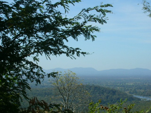
The view, and the winter sea of fog
The main view at Pha Sawoei is the Phu Phan valley running as far as you can see, with big trees covering the whole ridge and the flat Isan plains way off in the distance. The real draw is winter. From roughly November to February the air up here turns clearly cooler — some mornings it dips to 15–18°C before sunrise — and while the sun is still down, white fog floods the valley into a sea of fog, so the treetops look like they're poking up through clouds.
- Sea of fog — appears from dawn until around 7–8am on cold days with the right humidity. It's not guaranteed daily, but the odds are high in winter.
- Cool wind all day — even by mid-morning once the fog has thinned, the wind up here stays cool and pleasant. It really is an escape from the heat.
- Sunrise view — the deck faces the valley, so on a clear morning you'll see the first light cut against the ridge.
- Deck and viewing area — there's a railed spot to stand and take photos, safer than scrambling out to the cliff edge yourself.
Want the sea of fog? You really have to come early
The fog is thickest before sunrise. Leave Kalasin town around 5am and you'll reach Pha Sawoei just in time for the morning light. Show up after 8am and the fog has usually burned off. Bring a warm layer too — it's several degrees colder up here than down below.
Getting there and where it is
Pha Sawoei is right beside Highway 213 (the Kalasin–Sakon Nakhon road) in Somdet district, around the kilometer 101–102 marker. It's on your left if you're driving up from Kalasin toward Sakon Nakhon, about 58 km from Kalasin town — roughly an hour and a bit of driving. The big plus is that it's right on the main road: no turning onto gravel tracks, no hiking. That makes it easy for everyone, including anyone bringing older relatives or kids along.
- Self-drive — the easiest option. From Kalasin take Highway 213 north through Somdet district; it's paved the whole way, but the mountain stretch has curves and steep grades, so drive carefully, especially when fog drops visibility.
- Coming from Sakon Nakhon — drive south on 213 through Phu Phan National Park, and Pha Sawoei will be on your right before you reach the Kalasin boundary.
- No public transport at the spot — buses and vans on this route pass by but won't stop to let you off at Pha Sawoei. Your own car or a rental is by far the easiest way.
Driving the mountain when fog rolls in
If you come at dawn and hit thick fog, switch on your fog lights or low beams, slow down, and leave extra space behind the car ahead. This stretch is proper mountain road with one curve after another — don't get impatient and overtake.
Facilities at Pha Sawoei
Pha Sawoei has served as a pit stop for a long time, so it has the basics covered. Nothing fancy, but enough for a quick break.
Parking lot
A wide lot that fits plenty of cars, right by the road and easy to get in and out of. It gets busy in the winter season, so coming early makes finding a spot easier.
Stalls / food vendors
Vendors selling hot snacks, coffee, boiled corn, fried bites, and local souvenirs. They open when crowds show up, and in winter they're there nearly every day.
Shelter and restrooms
There are sala shelters to sit and get out of the sun, plus restrooms — handy for a stretch break on a long drive.
Honestly, Pha Sawoei works better as a stop than a full-day destination. Most people spend around 20–40 minutes here — photos, a hot coffee, the cool wind — and then drive on. To make the trip worthwhile, pair it with something else on the same route.
Where to go next on the same route
Pha Sawoei sits right on the route linking Kalasin's natural sights with Phu Phan, so once you're done you can keep driving to several more spots.
- Phu Phan National Park — on the same range, a bit further up toward Sakon Nakhon, with waterfalls and more viewpoints. A natural extension for a full-day nature trip.
- Kaeng Ka-am and the Somdet-area waterfalls — Kalasin's waterfall scenery, on the same side as the road up the mountain.
- Lam Pao Dam — if on the way back you want a fish meal and a wide-water view, you can loop back via Lam Pao.
- Kalasin town — head back to sleep and grab an evening meal in town, with a decent choice of Isan restaurants and cafes.
How to plan a short trip
If you've got half a day to a full day, here's a plan that uses Pha Sawoei as an early-morning start and flows on to Phu Phan and back to town.
Chasing the Pha Sawoei sea of fog
On to Phu Phan, then loop back
Before you go
- Go in winter — November to February is the best window for the sea of fog and the coolest air. In the rainy season the views are green but the proper sea of fog is rarer.
- Come early — the fog is thick before sunrise, so leaving while it's still dark pays off the most.
- Warm layer — it's colder up here than on the plains and the wind is strong, so pack a light jacket.
- Full tank — gas stations are scarce on the climb, so fill up before you set off.
- Mind the curves — this stretch of Highway 213 is mountain road with curves and steep grades, and the heavier the fog, the slower you should go.
Plan a whole Kalasin trip, from Phu Phan to Lam Pao Dam
See the Kalasin travel guide →