📝 Written 3 Jul 2026 · ✅ Fact-checked 3 Jul 2026 · prices and schedules can change — check with the operator before booking
Sa Kaeo sits in the eastern region bordering Cambodia, a land with traces of Khmer civilization and a wide range of natural landscapes. The highlight is Sdok Kok Thom, the largest Khmer castle in the eastern region, La-lu (Thailand's Grand Canyon) with its eroded earth pillars and cliffs, Pang Sida National Park with its waterfalls and butterflies, and the large Thai-Cambodian border market at Rong Kluea.
Below we've picked out the activities and attractions that come up most often in reviews, along with the best time to visit and what to know before you go. La-lu requires riding a community tractor-taxi in to see it, Pang Sida has butterflies swarming during the rainy season (May–July) and waterfalls that look best then too, and the sightseeing spots and border market are spread out beyond the city — you'll want a car and should check the border situation before heading out.
Sdok Kok Thom Castle (Historical Park, the Largest Khmer Castle in the Eastern Region, Khok Sung District)

Sdok Kok Thom is the largest Khmer castle in eastern Thailand, located at Ban Nong Ya Kaeo, Khok Sung Sub-district, Khok Sung District, Sa Kaeo province, roughly 34 kilometers northeast of Aranyaprathet District, close to the Thai-Cambodian border. The castle was built around the mid-11th century CE under King Udayadityavarman II, dedicated to Shiva according to Hindu belief. Its style is Khmer Khleang-Baphuon art, built from sandstone and laterite. The main components are a central sanctuary, two libraries, surrounded by a gallery and an outer wall, with a gopura (gateway) facing east, connected by a paved walkway flanked by boundary posts that stretches out to a large pond or baray outside the wall. The word “Sdok Kok Thom” in Khmer means a large city or castle overgrown with sedge reeds in a swamp, which accurately reflects the site's original condition.
What makes this castle especially significant isn't just its architecture, but the Sdok Kok Thom inscription, also known as inscription K.235, found at the northeast corner of the castle grounds. It's a grey sandstone slab roughly 1.51 meters tall, inscribed in both Sanskrit and Old Khmer across 340 lines. Its date corresponds to February 8, 1053 CE. The content records the succession of twelve Khmer kings across two and a half centuries and describes the devaraja (god-king) concept, which was a foundational belief of the Angkorian royal court. Historians consider this inscription one of the most important pieces of evidence for studying Khmer empire history, giving Sdok Kok Thom a significance beyond that of an ordinary stone ruin.
In terms of actually visiting, the Fine Arts Department surveyed and restored the site from the 1990s through the 2000s — clearing forest, digging out the moat, resetting fallen stones, and clearing residual unexploded ordnance from the past until the area was safe. It was then declared Thailand's 11th historical park in 2017. It's now open daily during the daytime, with a parking area and information signs. Keep in mind that it's quite far from town and located in a border zone — the most convenient way to get there is by private car or rental, as public transport barely reaches it. The castle grounds are an open, largely shadeless area, and midday sun is intense, so bring a hat, sunglasses, sunscreen, and water. Morning and evening light is softer and better for photos. Some of the walkways are uneven stone and can be slippery after rain, so wear comfortable walking shoes and take care climbing up and down the castle base.
- The largest sandstone-and-laterite Khmer castle in the eastern region, with a main sanctuary, two libraries, a gallery, and a boundary-post walkway — all the classic components to explore
- Site of the Sdok Kok Thom inscription (K.235), a major piece of historical evidence recording the succession of Khmer kings and the devaraja concept, so you get both beauty and knowledge in one visit
- Restored and elevated to Thailand's 11th historical park, with a parking area, information signs, and a well-organized site
- Less crowded than the famous castles in the northeastern region, so you can walk around and take photos comfortably, and admission is inexpensive
- Far from town and in a border zone, with public transport barely reaching it — you'll basically need a private or rental car
- The castle grounds are open and largely shadeless with intense midday sun — avoid noon and bring sun protection and water
- Some of the walkways are uneven stone and slippery after rain — take care climbing up and down the castle base
La-lu (Earth Grand Canyon) + Community Tractor-Taxi Ride to See the Eroded Earth Pillars and Cliffs, Ta Phraya District

La-lu is a natural phenomenon where reddish-brown earth has been eroded by rain and wind over many years into pillars, cliffs, and grooved formations of unusual shapes — some resembling a city wall, others like rows of stone cliffs standing in a line. This is why people commonly call it the “earth Grand Canyon” or the eastern region's version of Phae Muang Phi. The word “la-lu” is Khmer for “to punch through,” which matches how the eroded earth has become porous and hollowed out. The viewing area is at Ban Khlong Yang, Thap Rat Sub-district, Ta Phraya District, a border district on the eastern edge of Sa Kaeo province. The atmosphere is still quiet and uncrowded compared to mainstream attractions. Many people who've visited say in their reviews that it feels like stepping onto another planet, producing photos unlike anywhere else in the area.
What sets La-lu apart from typical natural attractions is the journey to reach it. The earth pillars themselves are deep inside villagers' farmland, with no direct road for cars to reach them. You have to park outside and ride a community tractor-taxi or modified farm vehicle with attached seating to get in — directly supporting the income of the Ta Phraya locals. The fare is charged per vehicle charter and varies by distance: nearby points are cheaper, while farther points with more complete earth-pillar formations cost more. Prices found in reviews range from roughly three hundred to five hundred baht per vehicle for foreign visitors, while Thai visitors often get a cheaper rate. Confirm the price and which points you'll be taken to before boarding, since each vehicle covers a different distance and takes different amounts of time. The site itself has no admission fee — you only pay for the community vehicle.
Here's what you should honestly know before going. First, timing: the best light is early morning and the period before sunset, since the angled light brings out dimension and shadow in the earth pillars and grooved cliffs, while midday sun is harsh, hot, and flattens the photos. Second, cliff-edge safety: many spots have high, steep earthen edges with no railing, and the loose soil can collapse easily, so don't walk close to the edge or climb up to stand on the pillars for photos, as it could be dangerous. Watch young children closely. Third, seasons: during the rainy season, the entrance path can become muddy and slippery, making it hard for the tractor-taxis to get through. The most convenient time to visit, when the ground is dry, is from late rainy season through winter, roughly November to February. Fourth, bring a hat, umbrella, water, and shoes suited for uneven ground, since the area is open with almost no shade and few shops or services.
- A landscape of earth pillars and cliffs eroded into unusual shapes, producing Grand-Canyon-like photos unlike any other attraction in the eastern region
- No admission fee — you only pay for the community tractor-taxi, directly supporting the income of Ta Phraya locals
- Still quiet and uncrowded — many real reviews praise the atmosphere as feeling like another planet, still retaining its original natural character
- Tripadvisor rates it around 4.2 out of 5, with most reviewers saying it's well worth it to see this kind of landscape
- Cars can't reach it directly — you must ride a community tractor-taxi, charged per vehicle charter with prices varying by distance, so confirm clearly before boarding
- Many cliff edges are steep, loose soil with no railing, risking collapse — take extra care and watch children closely
- The area is open with almost no shade, gets very hot at midday, and during rainy season the entrance path becomes muddy and slippery for vehicles
Pang Sida National Park — Pang Sida Waterfall, Pha Ta Khian Waterfall, and Rainy-Season Butterfly Viewing
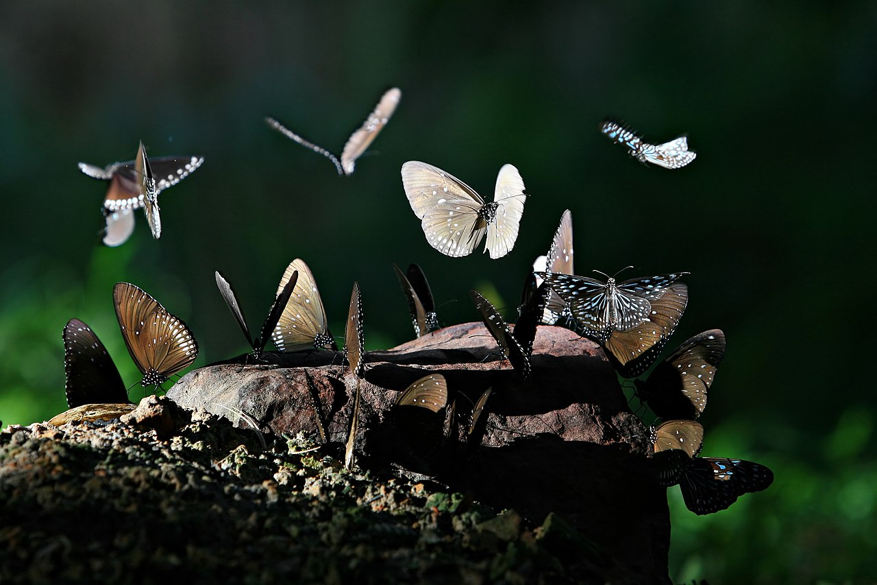
Pang Sida National Park lies north of Sa Kaeo town, part of the Dong Phayayen-Khao Yai forest complex that's registered as a UNESCO Natural World Heritage Site. The main attraction most people visit is Pang Sida Waterfall, not far from the park office — a short walk from the parking area brings you to the lower tier of the falls, a wide pool where you can stand and take photos. Those with more energy can hike further up to the upper tier. Another spot hikers enjoy is Pha Ta Khian Waterfall, which lies deeper in and requires a longer walk, suited to those ready for a real forest trek. The charm here is being surrounded by green forest and the quiet sound of water, less crowded than many famous waterfalls, and reachable from Bangkok in roughly 3-4 hours by car.
Another highlight that gives Pang Sida its reputation is butterfly season. From early to mid rainy season, roughly May through July, large numbers of butterflies come down onto the ground along the park's roads and around pools, with many species gathering in groups. Photographers and families bringing children to see nature often plan their trip specifically around this period. The park has even held a butterfly festival during this season. Butterflies appear in the greatest numbers mid-morning once the sun comes out after the previous night's rain — arriving too early or on an overcast day may mean seeing fewer. Visiting on a weekday also means less traffic and fewer people, making for more comfortable photography.
Here's what you should honestly know before going. The water volume in the falls depends heavily on the season — during the dry season, water can be scarce enough that it's less impressive than expected. The period with the most water and lushest green is late rainy season into early winter, but during heavy rain, rocks around the falls and the walking paths get very slippery, so take extra care. Wear shoes with good grip and don't walk close to the water's edge or swim during flash floods, since the current can be strong and water levels change quickly. Phone signal is poor in some parts of the park, so fill up on gas and bring your own water and food since shops are limited. The park entrance fee is charged separately for people and vehicles, with different rates for Thai and foreign visitors — bringing cash is most convenient for paying at the checkpoint.
- Pang Sida Waterfall is easily reached from the parking area, plus Pha Ta Khian Waterfall for hikers who want to go further
- During the rainy season (May-July), many species of butterflies gather in swarms on the ground — great for photographers and families bringing children to see nature
- Part of the Dong Phayayen-Khao Yai World Heritage forest, lush and green, with a quiet atmosphere less crowded than many famous waterfalls
- About 3-4 hours' drive from Bangkok — doable as a day trip or you can stay overnight in the park
- Water volume in the falls depends heavily on the season — during the dry season, water may be scarce enough to be less impressive than expected
- During the rainy season, rocks around the falls and walking paths get very slippery — take extra care and avoid swimming during flash floods
- Phone signal is poor in some spots and shops are limited — bring your own gas, water, and food
Rong Kluea Market (Ban Khlong Luek Border Market), Aranyaprathet — a Large Thai-Cambodian Border Market for Cheap and Secondhand Goods
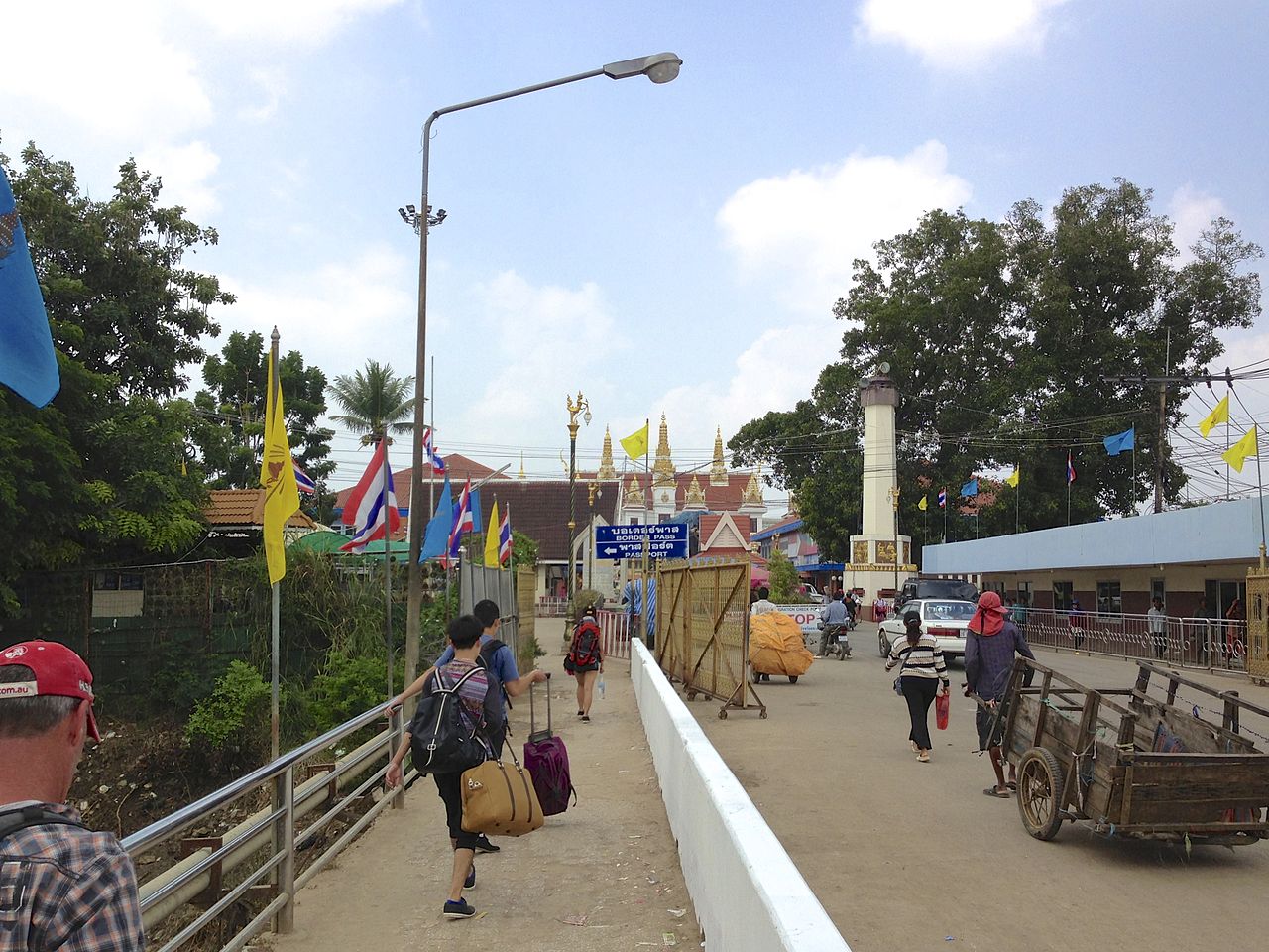
Rong Kluea Market, officially the Ban Khlong Luek Border Market, is located in Aranyaprathet District, Sa Kaeo province, right next to the Aranyaprathet-Poipet permanent border crossing, roughly 250 kilometers from Bangkok. It's a long-established, large-scale border trading market on the eastern side of the country. The main draw is cheap and secondhand goods of every kind — clothing, fashion bags, shoes, small electrical appliances, brassware, ceramics, and all sorts of odds and ends. The market is now divided into several zones, such as the Golden Gate zone, a roofed building sheltered from sun and rain, the new Rong Kluea market focused on bags and fashion items, the old Rong Kluea market focused on secondhand goods, and a zone selling shoes and first-hand wholesale factory goods. You can spend a whole day browsing and comparing prices.
The charm that visitors consistently mention is the sheer size and range of goods, more than you can cover in one visit, at prices far cheaper than in big cities, with bargaining expected as is customary at border markets. Many people come specifically for good-condition secondhand clothes, sneakers, bags, or affordable home décor, while some buy in bulk to resell. Beyond goods, there's also a section selling dried seafood, fish, and unusual snacks to browse. The market opens daily from around seven in the morning until evening. Most visitors park and walk around browsing, or use the golf carts and tricycles within the market to get around the many zones without walking far, since the market area is large with many lanes. Visiting on a weekday makes for a more comfortable walk than on weekends when it's crowded and hot.
Here's what you should honestly know before going. First, the border situation and the checkpoint's opening hours can change from time to time per official announcements, so check the news and confirm checkpoint and market opening hours in advance before setting out, since the market or checkpoint may occasionally adjust hours or close temporarily. Second, goods in the market are a mix of genuine, secondhand, and counterfeit items, so inspect the condition carefully before paying and bargain as appropriate — some secondhand pieces have flaws or faded color from use. Third, some outdoor zones of the market can be quite hot and dusty, with crowds on weekends, so bring a hat, water, and comfortable walking shoes, and keep your bag and valuables secure given the crowds. Fourth, given the long trip from Bangkok, set out early to have plenty of time to browse and get back before dark, and bring enough cash since many shops accept cash only.
- A large border market with plenty to browse across many zones — secondhand clothes, bags, shoes, and odds and ends, enough to fill a whole day
- Goods are far cheaper than in big cities, and bargaining is expected as is customary at border markets — great for both personal use and bulk buying to resell
- Roofed zones like Golden Gate shelter you from sun and rain, and golf carts/tricycles help you get around the many zones without walking far
- Open daily from morning to evening, free entry, and a chance to experience Thai-Cambodian border trading atmosphere hard to find elsewhere
- The border situation and checkpoint hours can change from time to time — check the news and market hours in advance before traveling
- Goods are a mix of secondhand and counterfeit items, some with flaws or faded color — inspect the condition carefully and bargain before paying
- Some outdoor zones are hot and dusty, crowded on weekends, and it's about 250 km from Bangkok — set out early and bring cash
Wat Tham Khao Chakan, Sa Kaeo (Limestone Mountain — Cave with an Opening, Resident Monkeys + Mountaintop Viewpoint)

Wat Tham Khao Chakan sits at the foot of a limestone mountain in the middle of Khao Chakan District, along Highway 317, roughly fifteen kilometers from Sa Kaeo town, making it a popular stop for drivers passing through this route to stretch their legs. The mountain has three limestone peaks, the highest around two hundred forty meters above sea level, riddled with small caves throughout. The most-visited spot is Khao Thalu Cave, a large opening in the cliff face that looks out like a giant natural window, with a wide view of rice fields and villages below. The way up is a naga staircase climbing the steep cliff face with over three hundred steps, requiring some leg strength and time, but the mountain-pass view at the top is worth the effort. Those who don't want to climb high can simply pay respects at the shrine in the lower hall and cave. The temple charges no admission — just a donation box as you wish, plus a shop selling monkey food.
What makes Khao Chakan memorable is the large troop of resident monkeys living around the temple, perched in trees, lined up along walkways, and playing on the banyan roots in front of the hall. Visitors can buy bags of corn or monkey food to feed them, a familiar sight here. Besides the monkeys, around dusk at about six in the evening, large numbers of bats fly out of the cave in a long stream that's worth standing to watch. On review sites like Tripadvisor, Wat Tham Khao Chakan holds an average rating of around 4.2 out of 5, though from a small number of reviews. Most feedback praises it as a shaded, pleasant mountainside temple where you can see the cave, the monkeys, and the view all in one place — better suited to a short stop along the way than a full-day trip, and appealing to those who want to pay respects in an old limestone cave temple.
Here's what you should honestly know before going. The biggest thing is the monkeys — while they're part of the charm here, the resident monkeys are very used to people and bold, often snatching food bags, glasses, hats, phones, and other loosely-held valuables. Keep items in a securely closed bag, don't carry a visible plastic bag, don't tease or stare at the monkeys, and be especially careful with young children. If feeding them, place or toss the food rather than holding your hand close. Second, the staircase up to the through cave, over three hundred steps, is quite steep and narrow, with handrails that aren't continuous in some sections, and the stone floor can be slippery when wet — wear shoes with good grip and climb steadily in stages. Elderly visitors, those with heart conditions, or anyone afraid of heights should think it over first. Third, sun and heat: the temple grounds are open and midday gets very hot, so go in the morning or late afternoon, and bring water, a hat, and sunscreen. Finally, some spots on the ground have monkey droppings and may be slippery, so watch your step and wash your hands before eating.
- See a limestone cave, a mountainside temple, a resident monkey troop, and a wide mountain-pass view from the through cave all in one place — a quick stop along the way works fine
- No admission fee, donation as you wish, right along Highway 317 only about 15 km from Sa Kaeo town — park and walk straight in
- The through cave is a large opening in the cliff face that looks out like a natural window, with a wide view of rice fields and villages below
- Real Tripadvisor reviews average around 4.2, with many praising the shaded, pleasant mountainside temple atmosphere, and in the evening you can watch bats fly out of the cave
- The resident monkeys are very used to people and bold, often snatching food bags, glasses, hats, and loosely-held valuables — keep items secure and watch young children closely
- The staircase up to the through cave, over 300 steps, is steep and narrow with inconsistent handrails, and the stone floor is slippery when wet — elderly visitors and those afraid of heights should think it over first
- The temple grounds are open with intense midday sun, and some spots have monkey droppings that may be slippery — avoid midday sun and watch your step
Prasat Khao Noi Si Chomphu (Khmer Castle on a Hilltop, Aranyaprathet District)
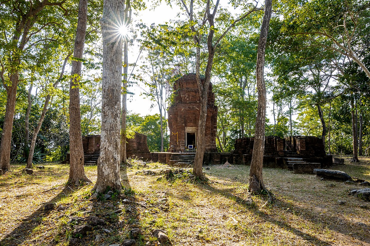
Prasat Khao Noi Si Chomphu is one of the oldest Khmer castles in the eastern region, sitting atop a small limestone hill within Wat Khao Noi Si Chomphu, Khlong Nam Sai Sub-district, roughly twelve kilometers south of Aranyaprathet town. The castle stands about one hundred thirty meters above the plain. Archaeologists believe it was built around the 7th century BCE (Buddhist Era 12th century), with later restoration in the Buddhist Era 15th century, originally a Hindu religious site. What makes this site academically significant is an inscription found here, dated to Mahasakaraj 559, corresponding to Buddhist Era 1180 (637 CE) — the oldest dated inscription found in Thailand. Those interested in ancient Khmer history often make a special trip up the hill to see it firsthand.
There are two ways up. The first is climbing a staircase from the temple grounds below, a total of 254 steps, gradually ascending through tree shade to the castle grounds at the top — a route hikers enjoy for the atmosphere and the exercise. The second option, for those who can't manage the long staircase, is to drive around the hill via the temple road for about one kilometer, then walk the remaining roughly two hundred fifty meters. At the top, what remains is the main tower along with collapsed tower remnants showing the old stone structure, opening onto a wide view of the Thai-Cambodian border plain. Many visitors say that climbing up before dawn to watch sunrise over the plain is a view worth the early wake-up. The historic site is open daily from roughly 8:30 to 16:00, with no admission fee.
Here's what you should honestly know before going. First, the 254 steps aren't brutal but are tiring enough for those who don't walk much regularly — allow time to rest and bring your own water, since there are no shops at the top. Second, this is still a quiet, uncrowded site — you may walk up without encountering any other visitors at some times. Since it's near the border, military personnel oversee the area, so it's safer to travel in a group and head back down before evening. Third, the castle itself is only ruins and a main tower, not as complete or grand as the major castles in the lower northeast — those expecting a fully intact structure may find it underwhelming. The charm here lies in its historical age, tranquility, and the view from the hilltop rather than architectural grandeur. Fourth, during the rainy season the stairs and stone ground can be slippery, so take extra care and wear shoes with good grip.
- An ancient Khmer castle from around the Buddhist Era 12th century, with an inscription bearing the oldest recorded date found in Thailand — history lovers can see the real thing up on the hill
- Sits atop an open hilltop with a wide view of the Thai-Cambodian border plain, a sunrise-viewing spot many say is worth the early wake-up
- Free admission, with both a staircase route for hikers and a road route around the hill for those who can't manage the long climb
- Quiet, uncrowded atmosphere, ideal for those who want to visit a historic site without fighting for photo spots
- Requires climbing 254 steps, tiring for those who don't walk much, and there are no shops at the top — bring your own water
- The castle is only a main tower and collapsed remnants, not as complete as the major castles in the lower northeast — those expecting a fully intact structure may find it underwhelming
- Near the border and fairly quiet — best to go in a group and head back down before evening, and during the rainy season the stairs and stone ground get slippery
Ta Phraya National Park — Border Forest Mountains, Cut-Stone Terrace, and the Chong Tako Viewpoint (Ta Phraya National Park, Sa Kaeo)

Ta Phraya National Park is a stretch of forested mountains along the Thai-Cambodian border, covering roughly 594 square kilometers (371,250 rai), spanning Ta Phraya District in Sa Kaeo province and continuing into several districts of Buriram province. It sits at the end of the Sankamphaeng mountain range where it meets the Phanom Dong Rak range, established as Thailand's 82nd national park in 1996 and part of the Dong Phayayen-Khao Yai forest complex registered as a UNESCO Natural World Heritage Site. Most of the area is mountainous, ranging roughly 206 to 579 meters above sea level, with Phran Nut Peak as the highest point, covered in mixed deciduous, dry evergreen, and dipterocarp forest — home to rosewood trees and various wildlife. What stands out here is that it's still quiet forested mountain terrain with few visitors, unlike famous parks such as Khao Yai or Thap Lan further west.
There are two main highlights people mention. The first is the cut-stone terrace, a fine-grained, greenish sandstone terrace still showing traces of stone-cutting into square blocks, believed to have been a quarry site for building castles and Buddha images in the Khmer era — offering both a wide stone-terrace view and a piece of history in one spot. The second is the trail leading up to the viewpoint on the ridge of the Phanom Dong Rak range, with a view over the sprawling Ta Phraya forest. The Chong Tako area and Wat Khao Chong Tako, opposite the park office, is the popular starting point. There's also Prasat Khao Lon, a small Khmer ruin, within the park grounds worth a visit. Most visitors travel from Aranyaprathet, getting off near Wat Khao Chong Tako opposite the park office. The park entrance fee for Thai visitors is in the tens of baht, with foreigners charged more. The best weather for hiking and reaching the viewpoint is winter, roughly November to January, when the air is cool and visibility is clear.
The most important thing to weigh before planning a visit is border-area safety. Ta Phraya National Park sits directly along the Thai-Cambodian border. During 2025, there was unrest along parts of the border, and the park has previously issued announcements banning entry to the area, with government agencies at times listing this area among places to avoid traveling to. The open/closed status can change with the situation, so check the latest announcements from the Ta Phraya National Park page or call the park office before setting out every time, and follow staff instructions strictly. Beyond the border issue, there are also natural forest-mountain precautions — some trail sections become slippery with soil and rock during the rainy season, phone signal is limited, and facilities are fewer than at popular parks. Anyone camping or staying overnight must bring their own bedding, tent, and food, and should hire or ask staff for a guide on unfamiliar trails to avoid getting lost and inadvertently approaching the border line.
- Quiet border-mountain forest with few visitors, part of the Dong Phayayen-Khao Yai World Heritage forest complex — uncrowded nature
- Features a cut-stone terrace still showing traces of Khmer-era stone-cutting for castle building, combining a stone-terrace view with a piece of history in one spot
- The trail up to the viewpoint on the Phanom Dong Rak ridge offers a view over the Ta Phraya forest stretching to the horizon, plus Prasat Khao Lon nearby
- Park entrance fee for Thai visitors is in the tens of baht, an affordable visit, with campsite/lodging available with advance booking
- Sits directly along the Thai-Cambodian border — during 2025 there was unrest and the park previously banned entry, so check the status and follow staff guidance before every visit
- An off-the-beaten-path park with fewer facilities, limited phone signal, and less convenient access than popular parks
- Some trail sections become slippery with soil and rock during the rainy season, and overnight campers must bring their own tent, bedding, and food
Sa Kaeo-Sa Khwan (Ancient Sacred Ponds, the Origin of Sa Kaeo Province's Name)

If you want to understand where Sa Kaeo province got its name, stop by Sa Kaeo-Sa Khwan, two ancient ponds that have sat side by side for a long time and became the origin of the whole province's name. Today both ponds sit within a public park in the town center, next to the Sa Kaeo Municipality Office, easy to reach from town without going far. This spot suits merit-makers and history lovers who like collecting each province's landmarks — a quick stop along the way, or a relaxed morning or evening stroll through the park.
The story tied to these twin ponds goes back to the Thonburi era, when an army led by a general who would later become King Rama I marched to campaign in Cambodia, and stopped to camp near these two ponds, using the water to sustain the troops before naming them Sa Kaeo-Sa Khwan. Later, the water from the ponds was designated as pure sacred water, used in the royal water oath ceremony (Phra Ratcha Phithi Thue Nam Phiphat Sattaya), a ceremony of swearing loyalty to the king. Belief in the water's sanctity persists to this day. Many who stop by don't just come for photos, but also to pay respects at the shrine beside the pond for good fortune. The area around the ponds is shaded by large trees, with history signs to read, and can be toured in a short time.
In terms of visiting, Sa Kaeo-Sa Khwan is more of a supplementary stop than a full-day destination, since the area isn't very large and the main activities are walking around, paying respects at the shrine, and taking photos. It pairs well with other attractions in town or along the way to Aranyaprathet, Rong Kluea Market, and the province's Khmer castles. The most comfortable time to stop by is morning or evening when the sun isn't harsh, for a comfortable walk around the park without the heat. Those interested in the city's historical roots will get more out of it by reading the history sign first, then walking to see the actual ponds — you'll see how two ordinary ponds became the name and symbol of an entire province.
- Directly the origin of Sa Kaeo province's name, with a history tied to the Thonburi era and the royal water oath ceremony worth learning about
- Located in a public park in the town center next to the municipality office, easy to reach without leaving town
- Free admission, no fee — a quick 30-45 minute stop for both paying respects at the shrine and taking photos
- Shaded by large trees with history signs, great for a morning or evening stroll
- A supplementary stop rather than a full-day attraction — the main activities are just walking around, paying respects, and taking photos
- Midday sun is fairly strong since it's an open area by the pond — best to avoid visiting around noon
- The ponds are an ancient water source whose charm lies in historical value rather than visual grandeur — those expecting a dramatic view may find it plain
Sa Kaeo's Reservoirs and Sunflower Fields (Tha Krabak Reservoir / Phra Prong Reservoir + Sunflower Fields Late in the Year)

If you want a quiet natural atmosphere in Sa Kaeo without a strenuous hike, these two reservoirs are the answer locals love to relax at. Tha Krabak Reservoir sits in Nong Ta Khian Bon Sub-district, Watthana Nakhon District, roughly 27 kilometers from Sa Kaeo town, and about 8 kilometers past Pang Sida National Park. It's an earthen dam over 700 meters long, built under a royally-initiated project. The reservoir has clear water reflecting the surrounding mountains, with green grassy areas and waterside pavilions to sit and relax. Most visitors come to rent pedal boats, sit and enjoy the view, take photos, and wait for sunset as the sky turns gold over the water. The other spot, Phra Prong Reservoir, also in Watthana Nakhon District, is a large reservoir holding tens of millions of cubic meters of water, offering raft rides, boat tours, fishing, and affordable fish restaurants by the water — good for anyone wanting lunch amid a natural setting.
What makes many people plan a visit late in the year is the sunflower fields. Sunflowers in the central and eastern regions typically start blooming from mid-November through December, right during the cool season. Most sunflower plots in Sa Kaeo belong to farmers and private operators who rotate their planting cycles, so they're not guaranteed to appear in exactly the same spot every year. Check the provincial tourism page or ask locals before setting out to find out which plot is blooming this year, since a field in full bloom really only lasts about one to two weeks. If you time it right at peak bloom, you'll get vivid yellow fields set against a mountain backdrop, but arrive too early or too late and you might find buds or fading flowers instead. Combining a reservoir visit with the sunflower fields in one day is a worthwhile plan, since both are in the Mueang Sa Kaeo-Watthana Nakhon zone, not far apart by car.
Here's what you should honestly know before going. First, this is a purely natural destination, not a theme park — facilities are limited, and restrooms and shops aren't available at every spot, so bring your own water, food, and trash bags, and take your trash back out with you. Second, both the reservoirs and the sunflower fields depend heavily on the season — during severe drought, water in the reservoir may drop enough to change the view, while sunflower fields only bloom during late rainy season into early winter, so visiting at the wrong time may mean just an empty field. Third, some sections of the road into Tha Krabak toward the end are narrow and remote — go during daylight hours, fill up on gas, and check the route beforehand, since phone signal is unstable in some spots. Fourth, if you're planning to watch sunset or camp overnight, bring a flashlight, insect repellent, and a jacket during the cool season, since nights by the reservoir get cooler and darker than in town. Arriving in the late afternoon gives you time to walk around before the evening light turns nice.
- A quiet natural atmosphere — relax by the reservoir, watch mountains reflected in the water, sunset, and morning mist without a strenuous hike
- Free entry to the reservoirs — Tha Krabak allows camping by the dam, while Phra Prong offers raft rides, fishing, and affordable fish restaurants
- Sunflower fields bloom late in the year for extra photos — combine a reservoir visit with the flower fields in the Mueang Sa Kaeo-Watthana Nakhon zone in a single day
- Close to Pang Sida National Park — easy to add on more nature or waterfall sightseeing in the same zone
- Sunflower fields only bloom late in the rainy season into early winter, in full bloom for just about 1-2 weeks and changing location every year — visiting at the wrong time may mean an empty field
- A purely natural destination with limited facilities — restrooms and shops aren't at every spot, so bring your own water, food, and take your trash back with you
- Some sections of the road toward the end into Tha Krabak are narrow and remote with unstable phone signal in spots — go during daylight and check the route beforehand
Walking Around Sa Kaeo Town-Aranyaprathet + Border Life (Town Streets, Markets, Food, Cafes, Border-Town Life)
Aranyaprathet is a border district of Sa Kaeo province adjoining Cambodia, and a town with a character you won't find in typical tourist towns. Its charm lies in being a melting-pot town of Thai, Chinese, Vietnamese, Lao, and Khmer people who've settled together, creating a way of life where language, food, and culture mix naturally. A leisurely walk through town reveals everything from old shophouses, fresh markets, and long-standing noodle shops to Aranyaprathet Railway Station, the terminus of the eastern rail line. Most visitors start in the town area in the morning, then move on to the big market once it gets busier later in the morning.
What draws travelers to Aranyaprathet is Rong Kluea Market, also known as the border friendship market, located at Ban Khlong Luek near the border checkpoint, roughly six kilometers from town. This is a large border trading market combining several smaller markets, with numerous shops selling secondhand clothes, bags, shoes, household goods, souvenirs, and cheap items that Thai shoppers love to browse. The atmosphere is a fairly large and somewhat complex market, with golf-cart rentals available in some zones for those who don't want to walk far. Throughout town and around the market, there's no shortage of border food to try — spicy, aromatic Thai-Khmer dishes, noodles, grilled chicken, som tam, sticky rice with grilled pork, and seasonal fruit. More recently, several nicely-designed cafes have opened for a rest stop during the day, making this a spot for town walkers, foodies, and shoppers alike.
Here's what you should honestly know before going. First, the weather here is hot with strong sun nearly year-round — walking the town and market outdoors in the afternoon gets tiring quickly, so start early and bring water, a hat, and an umbrella. Second, Rong Kluea Market is very large with a complex layout — first-time visitors can easily get lost, so remember your parking spot or take a photo of signage, and allow enough time to walk around. Third, most goods in the market are priced with bargaining in mind, and polite haggling is normal — check the condition of items carefully before paying, since they're a mix of secondhand goods and cheap items of varying quality. Fourth, during long holidays and weekends, it gets crowded with traffic backed up near the checkpoint, so go early or avoid peak times, and if you're planning to cross into Poipet, Cambodia, note that document requirements and checkpoint hours can change, so check the latest information before planning a crossing.
- Experience a border-town way of life blending Thai, Chinese, Vietnamese, Lao, and Khmer people — old shophouses, fresh markets, and the terminus of the eastern rail line
- Rong Kluea Market is a large border trading market with bargains on secondhand clothes, bags, shoes, and souvenirs — enough to browse all day, with golf-cart rentals available
- Diverse border food — spicy, aromatic Thai-Khmer dishes, noodles, grilled chicken, som tam, and several nicely-designed new cafes
- No admission fee for walking around town, affordable street food — good for town walkers, foodies, and shoppers alike in a single trip
- Hot weather with strong sun nearly year-round — walking the town and market outdoors in the afternoon gets tiring quickly, so start early and bring water and an umbrella
- Rong Kluea Market is large with a complex layout — first-time visitors can easily get lost, so remember your parking spot and allow enough time to walk around
- Crowded with traffic near the checkpoint during long holidays and weekends, and most goods are cheap secondhand items of varying quality — bargaining and inspecting items is necessary
Where to Stay When Visiting Sa Kaeo?
Choose a hotel in Sa Kaeo town, or the Aranyaprathet zone near Rong Kluea Market and the border. Compare prices across 3 sites before booking
Search hotels on AgodaBook Activities & Tickets in Advance
La-lu requires a community vehicle to get in, and Pang Sida's butterflies are seasonal — booking a vehicle or package in advance makes things easier
💡 Know Before You Visit Sa Kaeo
La-lu (earth Grand Canyon) requires riding a community tractor-taxi in to see the earth pillars and cliffs. Go in the morning or evening for the best light, bring sun protection, and take care along the cliff-edge paths
Pang Sida National Park has large numbers of butterflies during the rainy season (May–July) plus a lovely waterfall. There's a park entrance fee — watch for slippery paths and check trail conditions
Rong Kluea Market in Aranyaprathet District is a large Thai-Cambodian border market — check the situation and checkpoint hours before going, and watch your valuables in the crowds
Sdok Kok Thom is a Khmer castle on open ground. Go in the morning or late afternoon, and bring a hat, umbrella, and water. There's an information center
How to Plan a Worthwhile Sa Kaeo Trip
With 2 days, spend the first day visiting Sdok Kok Thom Castle and La-lu (riding the community vehicle), and the second day at Pang Sida National Park for the waterfall and butterflies (rainy season) plus shopping at Rong Kluea Market in the afternoon — that covers Khmer castles, nature, and border shopping. Sa Kaeo also pairs well with a trip to Prachinburi or Phanom Rung Castle
Ready to visit Sa Kaeo? Start by choosing a hotel in town
See Sa Kaeo hotels →