🔄 Updated 21 Jun 2026
When locals talk about Uttaradit's nature, two main zones come to mind: the Sirikit Dam area over in Tha Pla district, a short drive from town, and the mountain zone on the Laplae and Nam Pat side, which sits higher up where the air is cooler. We've ordered things from easiest to hardest to reach, so if you only have half a day you can pick a nearby stop, and if you've got several days you can head right up into the mountains.
Sirikit Dam — the easiest lake view to reach
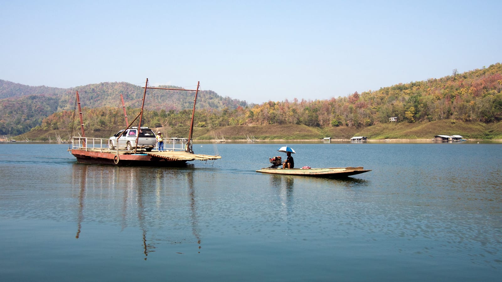
Sirikit Dam is in Pha Lueat subdistrict, Tha Pla district, about an hour's drive from Uttaradit town. It's the largest earth-fill dam in Thailand, holding back the Nan River to form a big freshwater reservoir above it. The standout view is from the top of the dam crest, looking out over the lake and the long line of islets, especially in the late afternoon when the sunset light spreads across the water. Entry is free with no admission fee, and there's a large parking area.
- Dam crest viewpoint — the main photo spot with the clearest view of the reservoir. Open all day, but late afternoon brings cooler breezes and nicer light.
- Raft cruises & kayaking — there are raft cruises across the lake, both day trips and overnight stays, plus jet skis and fishing.
- Restaurants & cafes on the crest — several spots up top; the signature dish is grilled tako carp, fish caught straight from the reservoir.
- Sirikit Dam guesthouses — EGAT runs guest accommodation, both standalone houses and rows of rooms, ideal for an overnight if you want to wake up to the morning view.
Best time to go
The cool season (November–February) brings pleasant weather and a full reservoir, so the views are at their best. If you go in the dry season the water drops a bit, but you'll see the islets poke out, which makes for an unusual look of its own.
Want more out of Uttaradit? Book tours & activities
Booking online ahead on Klook or GetYourGuide is usually cheaper than the gate and skips the queue. Pick only the experiences you actually want — prices and availability are shown live on each site.
Mon Laplae — a Lanna corner in a shady garden
Mon Laplae is in Fai Luang subdistrict, Laplae district. It's a stop that gathers restaurants, cafes and local souvenirs in one place, decorated in Lanna style amid green gardens, with several seating areas to rest your eyes. It's split into three zones — the Laplae souvenir house, the coffee shop and the restaurant — and opens roughly 9:00 to 21:00. It works better as a stop on your way around Laplae than as a full mountain viewpoint, but the shady setting and local food and souvenirs draw a steady crowd.
If you're in Laplae and want seasonal fruit, Mon Laplae sells Long and Lin Laplae durians, langsat and longkong when they're in season (around June–August). It's a convenient spot to grab souvenirs before you head home.
Rice fields and mountains of Laplae
Laplae's charm that many people overlook is the drive through the hillside rice fields, around Fai Luang and Mae Phun subdistricts, where small terraced paddies alternate with fruit orchards against a backdrop of mountains. Early in the rainy season (June–July) the fields are deep green, while toward the end of the rains and into the cool season some plots start to turn golden. It's a low-key photo spot that people haven't fully discovered yet, perfect for a slow morning drive when the light is soft.
- Phu Lae Lao — a two-nation viewpoint inside a wildlife sanctuary, looking down toward the Lao side. In the cool season there's a sea of mist, and people like to camp overnight to catch the fog at dawn.
- Mae Phun orchard route — drive past durian and langsat orchards on the hillside, with views opening up in patches; good for photo stops along the way.
- Phra Si Phanom Mat Monument & Laplae old town — not a mountain view, but a good starting point to wander the old town before heading up to the orchards and fields.
Drive carefully
The roads up the mountain on the Laplae and Phu Lae Lao side are narrow and steep in places, and slippery in the rain. We'd suggest a car with a bit of power and driving during daylight. If you plan to camp overnight at Phu Lae Lao, check with the wildlife sanctuary first about permits and weather conditions.
Phu Soi Dao — pine meadows and flower fields on the summit
Phu Soi Dao sits within Phu Soi Dao National Park in Nam Pat district, about 130 km from town. Its highest point is around 2,102 meters above sea level, among the tallest peaks in Thailand. What people come for is the wide pine meadow on the summit, where flower fields bloom in different colors with the seasons. The most famous is the field of purple hongnak flowers that blooms in the rainy season (August–September). This is serious hiking — the trail climbs steeply for several kilometers, so it suits people who've prepared their bodies and gear, not those looking for a quick photo stop.
- Phu Soi Dao Waterfall — a five-tier waterfall (Phu Soi Dao, Sakao Duean, Muean Fan, Kannika, Suphaphon) near the headquarters, with water year-round and far easier to reach than the summit.
- Phu Soi Dao summit pine meadow — you have to hike up and camp overnight on top; best in late rainy into cool season when the meadow is full of flowers.
- Hongnak flower field — the rainy-season highlight, purple blooms across the meadow. The trail is slippery this time of year, so tread carefully.
Plan ahead
Phu Soi Dao requires booking and contacting the park in advance, since there are periods when it closes for recovery and the number of visitors is capped. Most people hire local porters and guides. If you're not set up for hiking, just visiting the lower Phu Soi Dao Waterfall is enough to get the forest-and-mountain feel.
Where to go first
Uttaradit's nature spots are spread out in different directions, so it's best to choose based on the time you have. We've broken it down by day to make it easy to see what fits if you have one day or several.
Close to town, easy pace
Laplae + hillside rice fields
Add Phu Soi Dao
Plan a full Uttaradit trip across the whole city — food and places to stay included
See the Uttaradit travel guide →