🔄 Updated 21 Jun 2026
First, understand that 1090 isn't a road you just drive through — the road itself is the experience. It was built to follow the Thanon Thong Chai mountain range that marks the Thailand–Myanmar border, and the whole route is a narrow two-lane road climbing and dropping without a break. Nearly everyone who drives it for the first time says the same thing: it's more tiring than the kilometre count suggests. But once you see the ridgelines stacked up in layers, you understand why people put themselves through it.
The road has another name that foreigners use — the Death Highway. It sounds frightening, but the real reason behind it has nothing to do with how dangerous the road is today. It comes from a tragedy that happened while the road was being built decades ago. These days, if you drive slowly, stay alert, and bring a car that's in good shape, the road isn't as scary as its nickname. That said, you can't let your guard down, because the curves really do come one after another.
What the 1,219-curve road is, and what it's like to drive
The figure of 1,219 curves isn't marketing — it's the number of bends actually counted along the 164-kilometre route from Mae Sot to Umphang. In Umphang town there's even a sign with the number for people to photograph as a keepsake. The first 20 kilometres out of Mae Sot are still flat, hugging the Moei River, and easy to drive. After that the road starts climbing into the mountains and snakes up and down the ridgeline all the way to the end.
- Distance — about 164 kilometres, but don't go by the number, because it's mountain road the whole way
- Driving time — at least 4 hours without stops; with photo breaks and rest stops, plan for 5–6 hours
- Road condition — paved the whole way, two lanes, narrow shoulders, few roadside pull-offs
- Gearing — a regular sedan can handle it if it's in good shape; you'll need low gear to help brake on the long descents
Check before you set off
Brakes and tyres are the two things to be most sure about before tackling this road, because there are several long descents — weak brakes make it tiring and risky. Fill up the tank completely back in Mae Sot, since fuel stations along the way are few and far apart.
Want more out of Tak? Book tours & activities
Booking online ahead on Klook or GetYourGuide is usually cheaper than the gate and skips the queue. Pick only the experiences you actually want — prices and availability are shown live on each site.
Stops along the way, by the kilometre marker
The charm of 1090 is that there's something to stop for the whole way, especially in the first half out of Mae Sot — mostly pretty limestone waterfalls and viewpoints. Going by the kilometre markers, here's roughly what you'll find.
Tharn Rak Waterfall (around km 26)
A roadside waterfall pouring down a tall rock cliff, with a golden chedi perched on the cliff above it. A good spot to stop for photos and stretch your legs before the road starts curving hard. It's on the left as you come from Mae Sot.
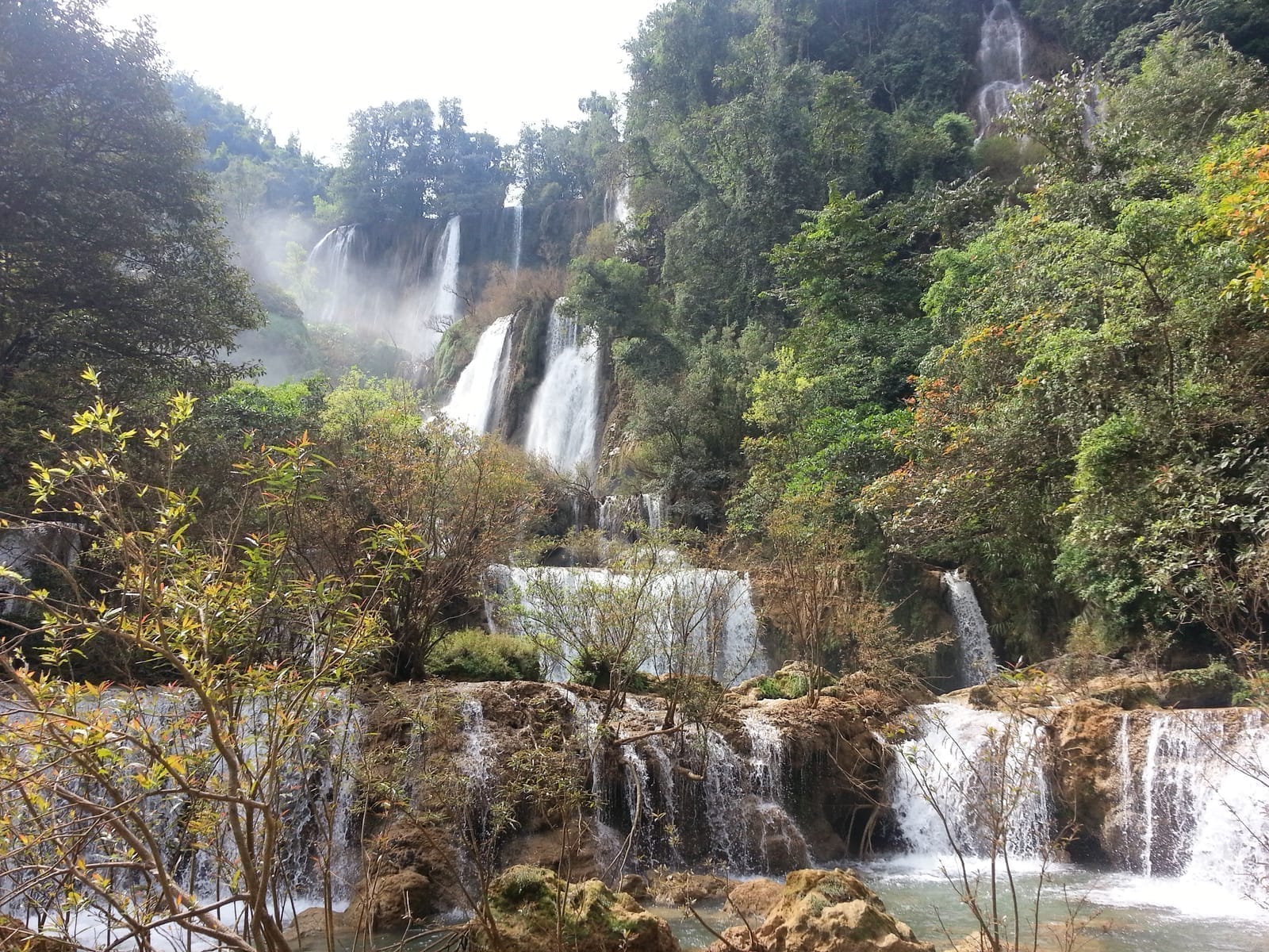
Pha Charoen Waterfall (around km 37)
The highlight of the early stretch — a limestone waterfall cascading down hundreds of small tiers, which is why people call it the 97-tier waterfall. It sits inside a national park with a restaurant and toilets, making it the main rest stop before the serious curves begin.
Mid-route valley viewpoint
About 40 kilometres before Umphang, there's a spot where the road opens up to ridgelines stacked in layers reaching all the way to the Myanmar side. Many people call it the most rewarding view on the whole route. On a clear day you can see ranges lined up in ribbons as far as the eye can see.
Mae Klong Headwaters Market (coffee)
A small coffee shop with snacks in the second half of the route, with toilets and basic essentials. A good place to take a break after a long stretch of curves, just before you reach Umphang town.
Where to take your motion-sickness pill
Pha Charoen Waterfall is the best place to take a motion-sickness pill if you're prone to it, because after that the road starts curving hard and doesn't let up. Taking the pill about 20–30 minutes before the curvy section works better than waiting until you start feeling queasy.
Valley views and the most beautiful stretch
If you ask which part of 1090 is the most beautiful, most people give the same answer: the second half, just before Umphang, where the road climbs high onto the ridgeline and opens up views of the valleys on both sides. In some sections it feels like you're driving along the actual spine of the mountain, looking down on green forest and thin mist drifting in the valley — and that's when you understand why they call it the sky highway.
Early morning through late morning is when the views are best, because the sky is still clear and there's a chance of seeing a sea of mist in the valleys. By late afternoon the light flattens out, and some days rain clouds roll in and hide the ridges. That's another reason people recommend leaving Mae Sot early — it's not only about safety, it's about the views too.
- Morning — clear sky, a chance to see the sea of mist in the high valleys, sharpest views
- Late morning — sun lights up the roadside waterfalls, the curtains of water show up clearly
- Late afternoon — light flattens, some days rain clouds hide the ridges, and you risk driving in the dark if you start late
Where this road takes you
Highway 1090 ends at Umphang, the deepest forest district in Tak. Most people who battle the curves all day do it to reach the places out here. If you're planning a trip, treat this road as only half the journey — the real destination needs several more days.
Thi Lo Su Waterfall
A massive limestone waterfall that many rank as the most beautiful in Thailand. You need a 4WD to get further in from Umphang town, and it's open for visits roughly September to May.
Doi Hua Mot
A bald-topped hill near Umphang town, a spot for sunrise and a sea of mist in every direction. You can head up from the early hours.
Mae Klong Headwaters Rafting
Rubber-raft trips past cliffside waterfalls and hot springs deep in the forest, most fun when the water is high in the rainy season.
Driving 1090 safely: tips from people who've been
This road isn't as dangerous as its nickname if you know how to drive and prepare well, but there are a few things people who've been keep stressing. Worth keeping in mind before you set off.
- Leave early — set off from Mae Sot before 9 a.m. so you reach Umphang before dark, avoiding the curves in the dark and the afternoon rain and mist
- Use low gear on descents — don't ride the brakes the whole way down; let engine braking slow you so the brakes don't overheat and fade
- Lights on and honk into blind curves — on many bends you can't see oncoming traffic, so switch on your lights and tap the horn as you enter blind corners
- Expect to lose signal — mobile signal drops out in patches in the high mountains, so download an offline map beforehand for peace of mind
- There are checkpoints — there are several checkpoints along the way since this is a border area; most just wave you through, but keep your ID on you
If you get carsick easily, sit up front
If you're travelling in a group and someone gets carsick easily, put them in the front seat looking far down the road — it's better than sitting in the back. Pack leak-proof plastic bags, a cool towel, and water in the car too. A thousand-plus curves is no joke.
Want a full Umphang itinerary for the end of this road?
See the Umphang travel guide →