🔄 Updated 21 Jun 2026
When people think of Narathiwat, the deep-south border situation often comes to mind before anything else. But on the nature side, this province has things others don't. Toh Daeng peat swamp is the largest freshwater peat swamp in the country, Pacho Waterfall pours off a tall rock face in the middle of Budo forest, and Ao Manao–Khao Tanyong is a southern-coast bay so quiet you can clearly hear the waves. The three sit in different corners of the province, so we've ordered them into a loop that doesn't backtrack.
Read before you go
Narathiwat lies in Thailand's deep-south border region. Before you travel, it's worth checking the latest news and safety announcements from local government agencies. Most of these nature sites welcome visitors as usual, but a quick situation check beforehand makes planning easier and gives you peace of mind. When you arrive, dress modestly and respect the Muslim Malay culture of the area, especially when entering villages or important sites.
The 3-day route at a glance
This trip uses Narathiwat town as a base, since it has the most accommodation and restaurants. Day 1 heads north to Bacho for Pacho Waterfall, Day 2 goes to the far south at Sungai Kolok to walk the Toh Daeng peat swamp, and the last day is an easy beach day at Ao Manao right next to town. Driving yourself is by far the most convenient option. The whole trip covers roughly 200 kilometres on good roads, with no rough going.
- Day 1 — Town → Pacho Waterfall (Bacho) → back to town · rainforest and a cliff-face waterfall
- Day 2 — Town → Toh Daeng peat swamp (Sungai Kolok) → back to town · a boardwalk through the swamp
- Day 3 — Ao Manao–Khao Tanyong · southern sea, a forest waterfall, then head home
Book the activities in your Narathiwat trip ahead
Booking online ahead on Klook or GetYourGuide is usually cheaper than the gate and skips the queue. Pick only the experiences you actually want — prices and availability are shown live on each site.
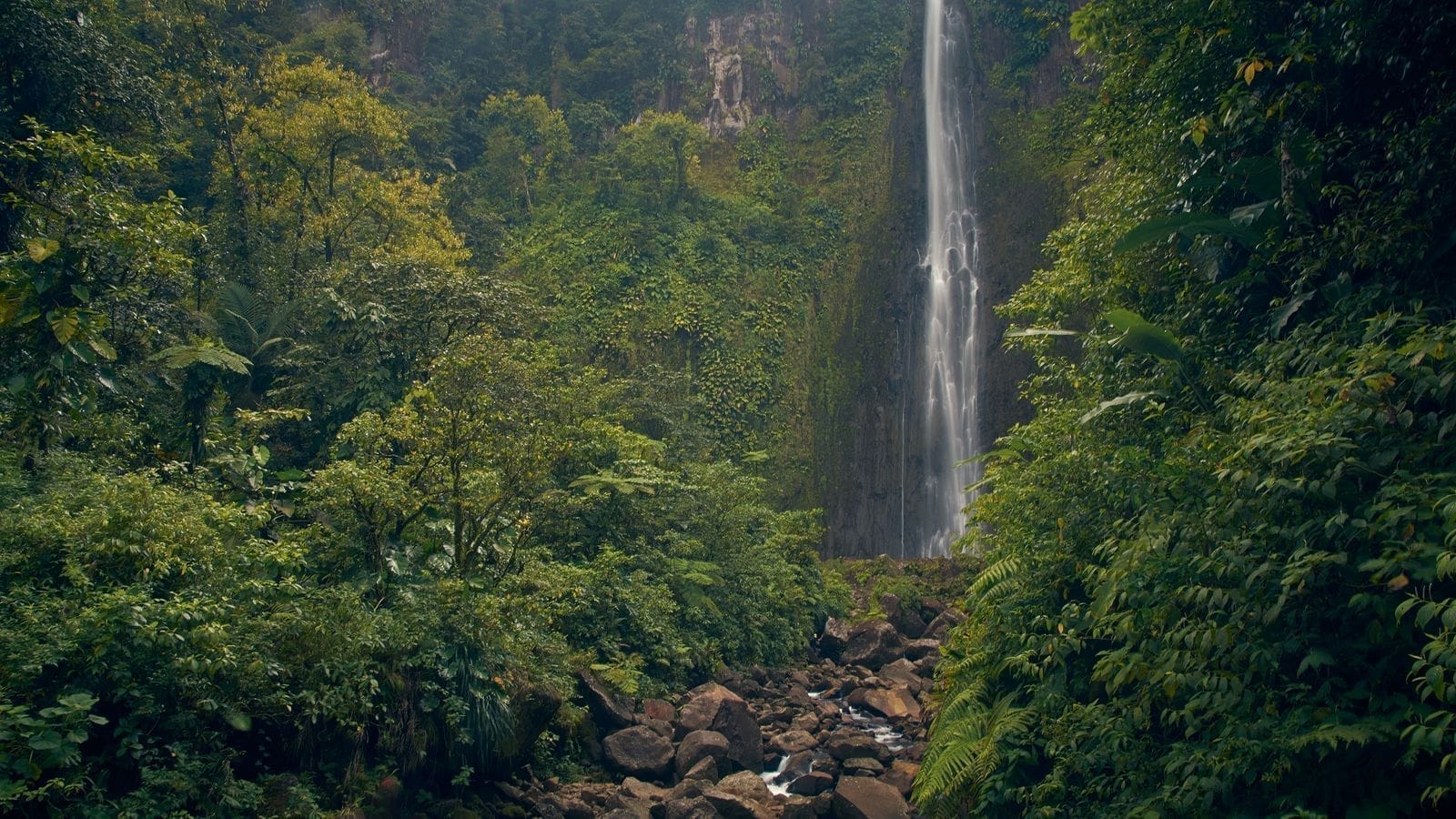
Day 1 — Pacho Waterfall in Budo forest
Pacho Waterfall sits inside Budo–Sungai Padi National Park in Bacho district, about 25 kilometres north of Narathiwat town, roughly a 35–40 minute drive. It's a wide cliff-face fall, with water dropping from a rock ledge about 60 metres high into a large pool. The falls have several tiers, and the lowest tier is the widest and prettiest. The surrounding rainforest is still intact, and if you're lucky you'll spot dusky langurs and forest birds nearby.
Narathiwat town → Pacho Waterfall → back to town
On the water flow
Pacho Waterfall has water year-round, but in the dry season (roughly February–April) the flow drops a lot. If you want to see the water covering the whole rock face, the period after the rains, from late in the year into early the next, looks better — though you'll need to be extra careful of slippery rock and flash flooding.
Day 2 — Toh Daeng peat swamp, a boardwalk through the bog
The Toh Daeng peat swamp, officially the Sirindhorn Peat Swamp Forest Research and Nature Study Centre, is in Sungai Kolok district and is the largest freshwater peat swamp in the country — around 120,000 rai total, with roughly 50,000 rai still in good condition. The highlight is a long boardwalk that lets you walk into the middle of the swamp without getting wet, plus a viewing tower for looking down over the forest canopy. The full loop is about 1.2 kilometres and takes around 45–60 minutes.
Narathiwat town → Toh Daeng peat swamp (Sungai Kolok) → back to town
Prepping for the peat swamp walk
The peat swamp is humid and full of mosquitoes, so wear a light long-sleeved top, long trousers, and pack insect repellent. Sneakers or hiking shoes are more comfortable than sandals. The morning is when birds and small animals show themselves the most.
Day 3 — Ao Manao–Khao Tanyong, the southern sea
Ao Manao–Khao Tanyong is a national park right next to Narathiwat town, in Kaluwo Nuea subdistrict. The highlight is a long curving beach running for about 4 kilometres, broken up by granite boulders, with clear water and gentle surf that's easy to wander along. Behind the beach rises Khao Tanyong, about 293 metres high, and if you walk into the forest from the shore for roughly 400 metres, you'll reach Thara Sawan Waterfall flowing down off the hill. It's an easy way to close out the trip before heading home.
Ao Manao–Khao Tanyong, then head home
The best time for the sea
This stretch of coast is good for swimming from May to mid-October. After that comes the monsoon, with stronger surf. The park usually closes parts of the beach for a spell, roughly 15 October to 30 November. If you're planning to swim, avoid the monsoon season and check the park's announcements first.
Getting around and where to stay
The easiest way to reach Narathiwat is to fly into Narathiwat Airport (NAW) and rent a car to drive yourself, since the three nature spots are in different directions and public transport doesn't reach them well. The airport and town have several car-rental operators, both self-drive and with a driver. If you'd rather not drive, hiring a car with a driver by the day is a route many people take, since local drivers know the roads and the local situation well.
- Base — Stay in Narathiwat town; it has the most hotels and lodging to choose from and easy access out to each spot
- Car — A self-drive rental is the most convenient, or hire a car with a driver by the day if you're not confident with the routes
- Cash — Bring cash; park fees and many local shops still only take cash
- Season — Avoid the year-end monsoon if you want to swim; the waterfalls look best after the rains
Local etiquette
Most people in Narathiwat are Malay Muslims. Dress modestly with shoulders and knees covered, especially when entering villages or mosques, ask before photographing people, and respect prayer times — it all helps you receive a warm welcome from the locals.
Want a well-located hotel in Narathiwat town as your base?
See the Top 10 Narathiwat Hotels →