🔄 Updated 21 Jun 2026
Sa Kaeo's nature clings to the Banthat and Phanom Dong Rak ranges along the eastern and northern edges of the province. This forest is part of the Dong Phaya Yen–Khao Yai complex, listed as a Natural World Heritage Site, which is why Sa Kaeo has waterfalls, caves, viewpoints, and butterflies to see early in the rainy season. We've ordered things from the easiest spots to reach to the ones that take a bit more effort, so you can plan around the time you have.
Pang Sida National Park — Forest, Waterfalls, and a Butterfly Town
Pang Sida is Sa Kaeo's main forest, in Mueang district to the north. You can reach the park headquarters by private car. The highlight near HQ is Pang Sida Waterfall, a three-tier rock-face waterfall about ten metres high, with a wide pool below that you can wade into during the rainy season. Around it there are picnic lawns, parking, and toilets, all a short walk from the car park — good if you want to see a waterfall without a hard trek.
What put Pang Sida on the map is its butterflies. Early in the rainy season, many species gather in swarms at mineral licks and along the streams. Butterfly season usually runs from around May to July each year, and the park often holds a butterfly-watching festival from June into early July. You'll see the most butterflies mid-morning around 9–11am and in the afternoon from 2–5pm. If you're coming specifically for them, check that year's schedule with the park's page first, since festival dates shift with the weather.
- Park entry fee — roughly ฿40 for a Thai adult, plus about ฿30 for a car (rates can change; double-check at the gate)
- Pang Sida Waterfall — the main waterfall near HQ, easy to walk to, strong flow in the rainy season
- Pha Takhian / Khwae Makha / Lan Hin Yai falls — smaller waterfalls deeper in, reached by trekking; better for hikers and best with a ranger guide
- Campground — the park has a campground and cabins; book ahead through nps.dnp.go.th
Before you go to Pang Sida
In the rainy season the forest roads get slippery and the falls run hard — watch the warning signs and don't get into the water during heavy rain. In the dry season the waterfall drops to a trickle, so if you're coming to swim, the early rains are the better bet.
Want more out of Sa Kaeo? Book tours & activities
Booking online ahead on Klook or GetYourGuide is usually cheaper than the gate and skips the queue. Pick only the experiences you actually want — prices and availability are shown live on each site.
Khao Chakan — Limestone Hill, a See-Through Cave, and Resident Monkeys
Khao Chakan is in Khao Chakan district, about 16 km from Sa Kaeo town along Highway 317 — a lone limestone hill rising from the fields, riddled with dozens of caves big and small. Wat Tham Khao Chakan sits at the foot of the hill, with several hundred steps climbing to a viewpoint and a see-through cave: a gap right through the rock that frames the fields below. Inside the cave there's an enshrined Buddha image.
Another draw is the monkeys. A large troop of resident monkeys lives around the temple and the steps up. You can buy food to feed them, but keep an eye on whatever's in your hands and bags — they're quick grabbers. The other sight people come for is the bats: millions of them streaming out of the caves in a long ribbon at dusk. If you want to catch it, wait near the foot of the hill toward evening.
- Best timing — climb in the morning or late afternoon to dodge the midday sun, since the steps are fully exposed
- What to bring — non-slip shoes, drinking water, and valuables stowed away from the monkeys
- Bats leaving the cave — wait around dusk, roughly 6pm, near the foot of the hill (depends on season and weather)
Lalu — Earth Carved by Rain into Strange Walls
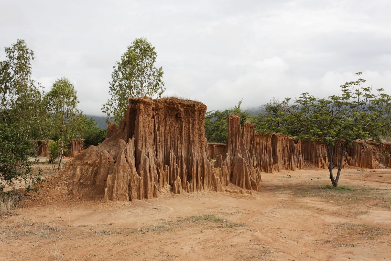
Lalu is in Tap Rat sub-district, Ta Phraya district — a landscape where rainwater erosion and soil collapse have left behind earthen pillars and walls in odd shapes. The word "Lalu" is Khmer for "to pierce through." Many compare it to Phae Mueang Phi or other earth-pillar formations, but here it's scattered in clusters across open ground, and the shapes keep changing with each year's rains.
The key thing: you can't drive in with your own car. You have to ride the villagers' farm tractors (rot e-taek) in, because the access route runs along narrow paddy bunds — and a local guide rides along to explain things. A tractor costs about ฿200 per vehicle and seats around 6 people. It's open roughly 8am–6pm. Go in the morning or evening, as the midday sun is fierce and there's no shade.
Making the most of Lalu
Lalu sits deep toward the border, so check the route and the weather before you set out. In heavy rain the paddy-bund track turns slippery and parts of it may be closed. Bring a hat, sunglasses, and water — and cash for the tractor, since ATMs are hard to find out there.
Ta Phraya National Park — World Heritage Forest on Phanom Dong Rak
Ta Phraya is a national park up on the Phanom Dong Rak range, straddling Sa Kaeo and Buriram, and part of the Dong Phaya Yen–Khao Yai World Heritage forest. The forest here is very rich, with hundreds of species of birds and wildlife, plus butterflies early in the rainy season, just like Pang Sida. The popular nature trail is near the Klang Dong ranger station, which leads up to a viewpoint on the Phanom Dong Rak ridge.
- Khao Yak Viewpoint — a broad sandstone terrace with large carved figures resembling people and open forest views
- Pa Salat Dai Viewpoint — an area dotted with salat dai (native cactus), giving it a look quite different from ordinary forest
- Klang Dong trail — the popular trek up to the ridge; best done with a ranger guide, and check with the park first
Ta Phraya runs right along the Thai–Cambodian border, so some trails and certain times may carry safety restrictions. Before you go, call the park to check and ask about the latest border situation, and don't stray off the routes the rangers set.
Check the border situation first
The nature spots on the Ta Phraya side and at Lalu sit near the border line, and the situation — along with route openings and closures — can change. Before you actually travel, check the news and ask the local park or district officials, carry your ID, and follow the rangers' instructions strictly.
More Nature Spots Around the Province
Tha Krabak Reservoir
A reservoir within Pang Sida, with mountains mirrored in the water — a good spot to stop for photos and a break on the way up to the park.
Flower fields at the foot of Khao Chakan
From late rainy season into early cool season, flower fields bloom at the foot of the hill, making a nice backdrop for the limestone peak.
Streams and butterfly licks
The streamsides in Pang Sida and Ta Phraya are where butterflies gather in swarms early in the rains — you can walk along the water to watch.
A 2-Day, 1-Night Sa Kaeo Nature Plan
Sa Kaeo's nature is spread in different directions. Pang Sida is north of town, while Lalu and Ta Phraya are further out to the northeast near the border. Doing it all in one day is too much, so we've laid out a 2-day plan with easier driving that still gets you forest, waterfalls, caves, and Lalu.
Pang Sida + Khao Chakan
Lalu + Ta Phraya
If you've only got one day, pick one of two routes: the forest-and-waterfall route (Pang Sida + Khao Chakan, close to town and an easy drive) or the strange-landscape route (Lalu + Ta Phraya, far out near the border). Don't try to combine both in one day — they're in different directions and you'll lose too much time driving.
Keep planning your Sa Kaeo trip — hotels, food, and things to do across the province
See the Sa Kaeo travel guide →