📝 Written 2 Jul 2026 · ✅ Fact-checked 3 Jul 2026 · prices and schedules can change — check with the operator before booking
Tak sits in the lower north on the border with Myanmar, with varied terrain spanning mountains, rivers, and border towns. Its most famous highlight is Thi Lo Su Waterfall in the Umphang Wildlife Sanctuary — a massive waterfall deep in the forest reached by truck and rafting. There's also the sea of mist at Doi Hua Mod, the town of Mae Sot with its Rim Moei market and blend of Thai-Myanmar culture, and Bhumibol Dam, a huge concrete arch dam.
Below we've picked out the activities and attractions that come up most often in reviews, along with the best time to go and what to know before you visit — especially for Umphang. Thi Lo Su looks its best with the most water from the rainy season into early winter (August–November). The drive to Umphang from Mae Sot follows a mountain road with over 1,200 curves and takes several hours, so most people go with a local tour that arranges the vehicle, rafting, and permits.
Thi Lo Su Waterfall tour, Umphang Wildlife Sanctuary (Mae Klong river rafting + 4WD truck + jungle trek, includes entry fee and permit)

Thi Lo Su Waterfall lies within the Umphang Wildlife Sanctuary in Umphang District, Tak Province, and is often ranked among the largest waterfalls in Thailand. The waterfall itself is a limestone cliff roughly three hundred meters high and nearly five hundred meters wide, with water cascading down in tiers that spread across the entire cliff face — especially dramatic when water levels are high. What sets Thi Lo Su apart from typical waterfalls is that it's hidden deep in the forest on the Thai-Myanmar border. You can't reach it in an ordinary car; you have to join a tour that includes a 4WD ride through rough jungle tracks, and many operators add a rafting segment down the Mae Klong River past cliffs and caves along the way, before a roughly 1.5-kilometer walk on a paved path to the viewing area.
Because it lies within a wildlife sanctuary, visiting Thi Lo Su requires advance permission and the number of visitors per day is controlled. Group tour packages based in Umphang typically run from around two thousand nine hundred to three thousand five hundred baht per person, covering one night's accommodation, meals, sanctuary entry fees, and permit arrangements. Packages departing from Bangkok with round-trip van transport start from around three thousand nine hundred baht. Foreign tourists usually pay an additional fee of about four hundred baht. Booking through an online platform in advance makes it easier to compare what's included between operators — the number of days, and whether the trip includes rafting or stops at other spots like Rainbow Waterfall, Doi Hua Mod, or the hot springs. On Tripadvisor, Thi Lo Su holds an average rating of around 4.5 out of 5 from roughly eighty reviews, with most praising it as one of the most beautiful waterfalls they've seen in Thailand.
A few honest things to know before you go. First, the journey itself is tough — from Mae Sot you'll climb through more than one thousand two hundred curves over about four hours, so bring motion sickness medication if you're prone to it. Second, the water volume depends heavily on the season. The fullest, greenest water is from late rainy season into early winter, roughly August to November, while the dry season sees much less water, and around March haze from burning can affect visibility. Third, the roads within the sanctuary are rough dirt tracks with some deep potholes, requiring a genuine 4WD vehicle. Fourth, you must apply for a permit in advance — ideally at least seven days ahead, or let the tour operator handle it for you, since showing up at the checkpoint without one may mean you're turned away. Bring shoes suited to both paved and dirt paths, a rain jacket, and cash for any separately charged fees.
- One of Thailand's largest limestone waterfalls, roughly 300 meters high and nearly 500 meters wide — spectacular across the whole cliff face when water levels are high
- The trip packs in multiple experiences at once: rafting the Mae Klong River, riding a 4WD through the jungle, and trekking in to the waterfall itself
- Most Umphang-based group packages include accommodation, meals, sanctuary entry, and permit arrangements, so you don't have to handle the paperwork yourself
- Real Tripadvisor reviews average around 4.5 out of 5, with many calling it one of the most beautiful waterfalls they've seen in Thailand
- The journey is long and rough — from Mae Sot you'll climb through more than 1,200 curves over about 4 hours, so those prone to motion sickness need to bring medication
- Water volume depends heavily on the season — much less in the dry season, and around March haze from burning can affect visibility
- You need a permit to enter the wildlife sanctuary in advance, with a daily visitor quota — showing up at the checkpoint without one may mean you're turned away, and foreigners pay an extra fee
Umphang rafting on the Mae Klong River to Thi Lo Su waterfall
Umphang rafting is one of the signature activities of Umphang District, Tak Province. The highlight is riding an inflatable raft down the Mae Klong River through still-pristine mountain forest, with tall rock cliffs and large trees on both banks. Along the way you'll pass several scenic spots, such as Pha Luead, a red-tinted cliff, Pha Wo with its rock cavity, hot springs, and Thi Lo Jo waterfall, which flows down right beside the river as you pass. Most trips end at Thi Lo Su, the large waterfall that requires a further truck ride and jungle trek to reach. Most of the rapids aren't especially rough or intense the way full white-water rafting can be, so the focus is more on enjoying the scenery than seeking thrills — ideal for anyone who wants to experience deep forest without having to hike the whole way.
The most popular format is a 2-day-1-night or 3-day-2-night package, since Umphang is remote and the mountain roads wind considerably. Buying a package from a local operator typically bundles the rafting, accommodation, meals, a guide, and a 4WD vehicle for the unpaved stretch to the waterfall. A typical itinerary involves rafting for about two to three hours in the morning, then staying overnight before trekking in to Thi Lo Su Waterfall the next day. The river runs fullest and the waterfalls flow strongest during the rainy season, roughly August to November — the most photogenic time, but also one that calls for extra care around safety. Choose an operator with guides experienced on the route, life jackets for everyone, and confirm whether the quoted price already includes the wildlife sanctuary entry fee and raft fee or charges them separately.
A few honest things to know before you go. First, Umphang is a difficult place to reach — Highway 1090 from Mae Sot has thousands of curves, so bring motion sickness medication if needed. Second, during the rainy season the rapids run strong and water levels can change quickly; if heavy rain falls, operators may cancel the rafting for safety, so don't push back if your guide says it's too risky, and you must wear a life jacket at all times on the raft. Third, reaching Thi Lo Su requires an additional jungle trek with some slippery stretches, so wear shoes with good grip and pace yourself. Fourth, phone signal in the area is limited, so let family or your accommodation know your plans in advance and carry essentials with you. In the dry season, roughly March to May, water levels drop so much that some stretches become unraftable — check with the operator before planning your trip.
- Get an up-close raft ride through Umphang's dense mountain forest, passing cliffs, Pha Luead, Pha Wo, hot springs, and Thi Lo Jo waterfall along the way
- Most rapids aren't rough or intense — the focus is on scenery rather than thrills, making it suitable for beginners, couples, and families who can swim
- The trip ends at Thi Lo Su Waterfall, which real Tripadvisor reviews rate around 4.5 out of 5 and rank as the number-one thing to do in Umphang
- Local packages bundle rafting, accommodation, meals, a guide, and a 4WD vehicle, so you don't have to arrange multiple pieces yourself
- Umphang is difficult to reach — Highway 1090 from Mae Sot has thousands of curves, so those prone to motion sickness need to bring medication
- During the rainy season the rapids run strong and water levels can change quickly; operators may cancel the rafting for safety if heavy rain falls
- Reaching Thi Lo Su requires an additional jungle trek with some slippery stretches, and in the dry season, roughly March to May, low water can make some stretches unraftable
Doi Hua Mod — sea of mist and sunrise viewpoint, Umphang District, Tak

Doi Hua Mod is an open grassy ridge above Umphang town, Tak Province, sitting at roughly 900 meters above sea level. The name comes from the bald appearance of the summit, covered only in grass and low shrubs with no tall trees blocking the view, so it offers nearly 180 degrees of unobstructed scenery. Most visitors come specifically to watch the sea of mist and sunrise in the early morning: once the cool night air and accumulated humidity meet the first light of dawn, mist rises to fill the valley below in a broad white expanse that gradually shifts color with the early sunlight. The main viewpoint sits around kilometer marker 9, requiring about a 20-minute walk up a grassy slope from the parking area — moderately steep but not especially difficult — leading to a ridge-top clearing that overlooks both the sea of mist and Umphang town below.
Most people head up between before 5am and around 6am, to catch the moment the sun clears the ridgeline while the mist is still thick. The chances of thick mist are highest in late rainy season into winter, roughly November through February. The air on the ridge is quite cool with a constant breeze, so bring a jacket or windbreaker even if you're coming from a warm lowland area. Reaching Doi Hua Mod requires continuing on from Umphang town, which is itself remote with winding mountain roads. Those not driving themselves usually hire a local vehicle or include Doi Hua Mod as part of an Umphang tour that also covers Thi Lo Su Waterfall and other sights in a single trip.
A few honest things to know before you go: the road up the hill is narrow with steep, winding curves, and some sections have uneven surfaces, so use a vehicle in good condition with a driver familiar with the route, and avoid driving yourself at night if you don't know the road well, since you'll need to head up while it's still dark. Also, the sea of mist depends entirely on weather conditions — on some days with low humidity or strong wind there may be no mist at all, so temper your expectations; you might only get mountain views and a sunrise. The summit is an open natural area with few shops or restrooms, so bring your own water and snacks, and help carry out any trash, since it's a watershed and conservation area within the western forest complex.
- An open grassy ridge with no tall trees blocking the view — nearly 180 degrees of sea-of-mist and Umphang town scenery
- A recommended spot among Umphang locals for sunrise and morning sea of mist; the chances of thick mist are highest in late rainy season into winter
- Free to visit with no entry fee — only about a 20-minute walk from the parking area to the viewpoint, moderately steep but not too demanding
- Often included in Umphang tours that also cover Thi Lo Su Waterfall and other sights in one trip, convenient for those not driving themselves
- The road up is narrow, steep, and winding with some uneven sections — not ideal for driving yourself at night if you're unfamiliar with the route
- The sea of mist depends entirely on weather conditions — some days with strong wind or low humidity may have no mist at all
- Requires waking up before dawn; the summit is cold and windy, and being an open area, has few shops or restrooms
Mae Sot + Rim Moei border market, Thailand-Myanmar border (Rim Moei border market & Mae Sot town, Mae Sot District, Tak)
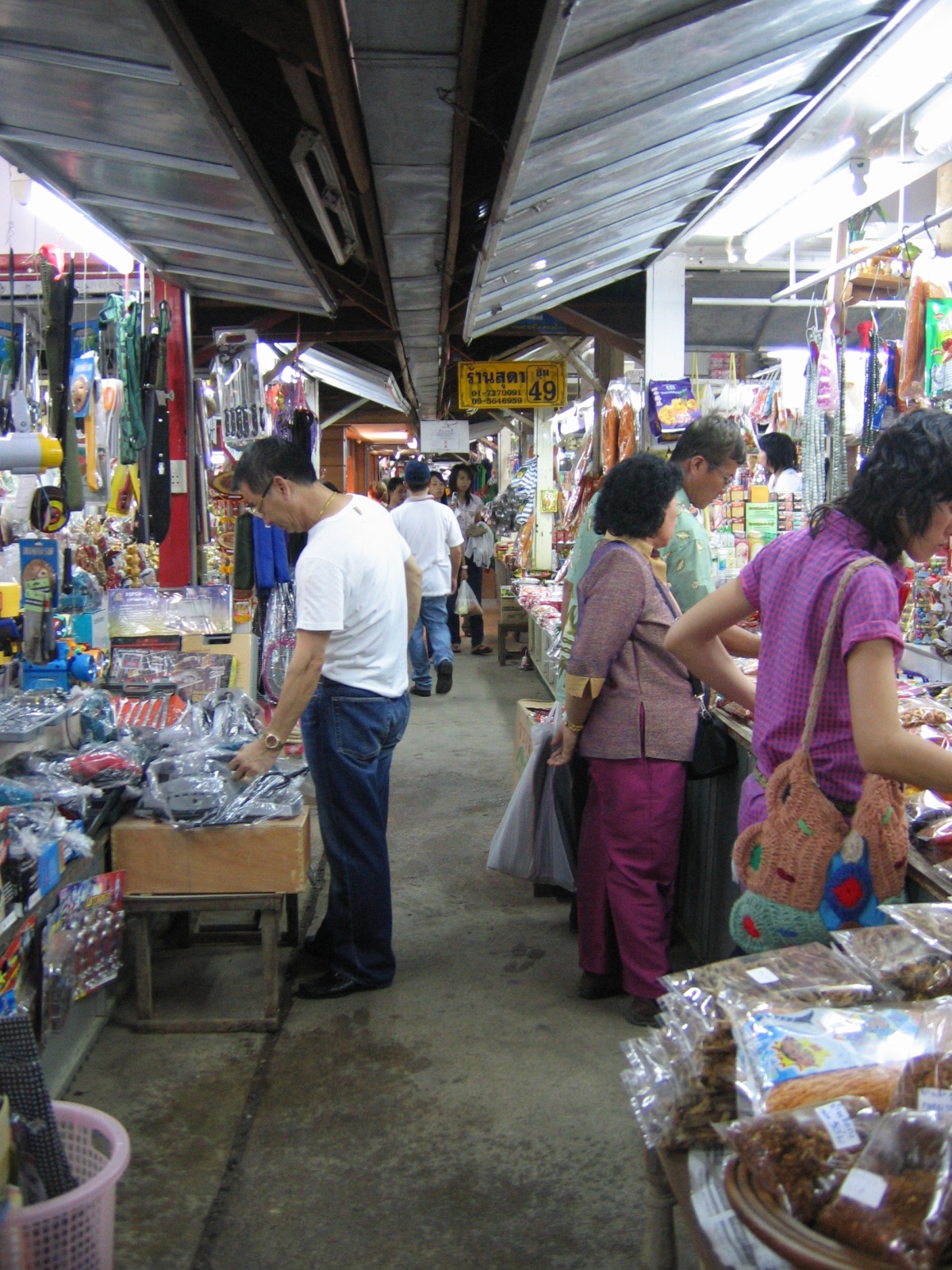
Mae Sot is a western border district of Tak Province, sitting directly across from Myawaddy in Myanmar with the Moei River as the dividing line. The charm here lies in its multicultural character — walking through town you'll see Thai, Tai Yai, Burmese, Muslim, and Chinese communities living side by side, with Thai temples, Burmese temples, a mosque, and restaurants of several nationalities all within walking distance of each other. A must-visit for anyone touring Mae Sot is Rim Moei market, a border market along the Moei River right next to the Thailand-Myanmar Friendship Bridge, about five to six kilometers from downtown. It sells food, souvenirs, woven textiles, carved woodwork, silverware, and gemstones from the Myanmar side, with the lively atmosphere of a genuine trading border market rather than a tourist-oriented setup.
What makes Rim Moei market worth strolling through is the food you can't easily find elsewhere in Thailand, from Burmese snacks and tea to nuts, spices, and Tai Yai dishes like khao soi noi or khanom jeen nam ngiao. Prices for street food start at just a few tens of baht. Popular souvenirs include Burmese-patterned woven fabric, teakwood items, and small trinkets that you can bargain for. If you're interested in gemstones or colored stones, there are shops to browse, though it's worth having some basic knowledge or going with someone experienced before buying anything expensive. Getting from downtown Mae Sot to Rim Moei is convenient — a shared songthaew running to the bridge costs just a few tens of baht, or you can rent a motorbike or drive yourself since the road is straightforward with clear signage. Beyond the market, you can also stop by Wat Thai Watthanaram, home to a large Burmese-style Buddha statue, and stroll through the old town area with its aging shophouses and cafes, all in one trip.
A few honest things to know before you go. First and most important: the situation at the Mae Sot-Myawaddy border can change at any time depending on developments in Myanmar. The border checkpoint and Friendship Bridge may open, close, or restrict crossings periodically, so check the news and announcements from the Mae Sot immigration checkpoint before planning, especially if you're considering crossing over to the Myawaddy side, since visa conditions and crossing rules are unpredictable and often discouraged or prohibited. Second, Rim Moei market operates mainly during the day and is busiest from morning through afternoon, so go in the late morning when stalls are fully open and the heat isn't yet intense. Third, as a border market, keep an eye on your belongings and valuables, negotiate prices before buying, and watch out for counterfeits, especially gemstones and branded goods. Fourth, during the rainy season some roads and riverside areas can get slippery and muddy, so wear comfortable walking shoes and allow extra travel time.
- A genuine Thailand-Myanmar border market right along the Moei River next to the Friendship Bridge, with a lively atmosphere rather than a tourist-oriented setup
- Offers Thai-Burmese-Tai Yai food that's hard to find elsewhere in Thailand — great for grazing, with prices starting at just a few tens of baht
- A wide variety of souvenirs including Burmese-patterned woven fabric, teakwood items, silverware, and colored stones, all negotiable
- Easy to reach from downtown Mae Sot via a shared songthaew for just a few tens of baht, and can be combined with Wat Thai Watthanaram and the old town area in one half-day trip
- The Mae Sot-Myawaddy border situation can change at any time — the checkpoint and bridge may open, close, or restrict crossings periodically, so check the news beforehand
- As a border market, you need to watch your valuables, negotiate prices before buying, and watch out for counterfeits, especially gemstones and branded goods
- The market operates mainly during the day, and during the rainy season some roads and riverside areas can become slippery and muddy
Boat trip/raft-house on the Bhumibol Dam reservoir + stay on a floating raft in the middle of the lake (Bhumibol Dam reservoir cruise & raft-house, Sam Ngao District, Tak)

Bhumibol Dam in Sam Ngao District, Tak Province, is a large concrete arch dam holding back the Ping River. The dam itself stands roughly one hundred and fifty-four meters from base to crest, creating a vast reservoir that stretches far to the north. The activity most visitors come for isn't just taking photos in front of the dam, but boarding a boat or raft out into the middle of the lake. Both shores are lined with lush green mountains alternating with rocky cliffs, the water is calm, and the air is cooler than the lowlands. Boat routes typically stop at riverside sights such as Valentine Island, the Buddha's footprint at Khao Nam, and Wat Phra Borommathat Kaeng Soi, with some routes cruising all the way to Doi Tao on the Chiang Mai side. It's ideal for anyone seeking a quiet, natural atmosphere without the crowds.
Services come in several tiers. If you're short on time, choose a half-day round-trip lake cruise, stopping at a couple of scenic viewpoints and riverside temples before heading back. But for the full experience, an overnight raft-stay package of one to two nights is the option most people talk about most. A boat tows the raft out to anchor at a scenic spot on the water, with rooms on the raft and freshly cooked meals throughout the trip. During the day you can swim, fish, or sing karaoke, and at night fall asleep to the sound of water lapping against the raft. Booking in advance through an operator lets you compare how many meals are included, which sights are visited, and whether pricing is per-charter or per-head. The per-person price drops significantly with a larger group, since the raft charter and boat fuel costs are shared.
A few honest things to keep in mind before you go. First, reservoir water levels rise and fall clearly with the seasons — late rainy season into early winter, roughly November to January, brings the fullest water and best views, while the dry season sees water levels drop significantly, leaving some spots shallow and changing the scenery. Check with the operator beforehand whether your desired route is still navigable. Second, reaching the pier is fairly far from Tak town, with a winding mountain road for the final stretch, so those prone to motion sickness should bring medication. Third, rafts and boats vary in standard between operators — choose one with full life jackets and clear reviews, and ask about safety and passenger limits per raft before booking. Fourth, phone signal in the middle of the lake is often weak or nonexistent, so let people at home know your plans in advance and pack all necessities, since it's hard to buy anything once you're out on the water.
- A peaceful getaway on a raft in the middle of the reservoir above the dam, with lush green mountain views on both sides and cooler air than the lowlands
- The boat route stops at several riverside sights, such as Valentine Island, the Buddha's footprint at Khao Nam, and Wat Kaeng Soi
- Options range from a half-day round trip to an overnight raft stay of 1-2 nights, with freshly cooked meals, swimming, fishing, and karaoke on the raft
- Traveling as a larger group brings the per-person cost down significantly by sharing the raft charter and boat fuel fees
- Water levels rise and fall with the season — in the dry season some spots become shallow and some routes become unnavigable, so check before booking
- The pier is far from Tak town, with a winding mountain road for the final stretch, so those prone to motion sickness need to bring medication
- Rafts and boats vary in standard between operators, and phone signal in the middle of the lake is often weak or absent, so pack everything you need in advance
Thararak Waterfall (limestone curtain waterfall) along the Mae Sot-Umphang road

Thararak Waterfall is a medium-sized limestone waterfall located right along Highway 1090, the Mae Sot-Umphang road, in Umphang District, Tak Province. What draws so many visitors to stop here is that the waterfall sits right next to the road, barely requiring any walk at all — just park roadside and walk a few steps to reach it. It's a great spot for anyone who's been driving the winding, hilly route to Umphang and wants to stretch their legs and take a break. What makes this waterfall special is its limestone cliff face, with water spreading down to cover the rock in a wide sheet resembling a curtain, moss and greenery clinging to the surface, giving it a fresh, natural feel for photos. Many people passing this route stop to snap photos as a roughly midway landmark before reaching the district town.
Thararak differs from a large waterfall like Thi Lo Su in that it requires no jungle trek or rafting — it's a quick stop that takes very little time. Most people park, take photos, splash some water on their face to freshen up, and drive on. There's no entry fee since it's a public roadside spot, so the real cost is just fuel or car rental and tour fees for the Umphang route. If you're not driving yourself, you'll likely stop here anyway, since it's a spot where tour buses and vans commonly pause on the way up to Thi Lo Su or down from Umphang. The waterfall looks its best, with the fullest curtain of water, from late rainy season into early winter, roughly October to January — the same period most people visit Umphang.
A few honest things to know before you go. First, water volume depends heavily on the season — during the dry season, roughly March to May, the water may run thin and the curtain won't look as full as in photos. Second, the waterfall sits right beside a curving mountain road, so parking and getting out to take photos requires caution around passing traffic; park somewhere clearly visible and turn on hazard lights. Third, the limestone surface, wet and covered in moss, is very slippery — don't climb up close to the waterfall for photos, as the risk of slipping is high. Fourth, the Mae Sot-Umphang route has hundreds of winding curves, so those prone to motion sickness should take medication in advance, and planning a stop here as a break along the way makes the trip more comfortable. Finally, since it's a small stop, facilities are limited, so bring your own water and snacks.
- Right beside the Mae Sot-Umphang road — park and walk just a few steps to reach it, no jungle trek or heavy hiking required, making it a great rest stop along the way
- The cliff face is limestone, with water spreading down like a curtain and green plants clinging to the surface, giving a fresh, natural feel for photos
- No entry fee since it's a public roadside spot — stop freely and it takes very little time
- Sits along the same route as the Thi Lo Su-Umphang trip, so tour buses and vans commonly stop here anyway
- Water volume depends on the season — in the dry season, roughly March to May, the curtain often runs thin and doesn't look as full as in photos
- Sits beside a curving mountain road, so parking and taking photos requires watching for passing traffic, and the moss-covered limestone surface is very slippery
- A small stop with limited facilities, so bring your own water and snacks
Lan Sang National Park — multi-tier waterfall, easy jungle trekking and swimming near Tak town

Lan Sang National Park sits on the Thanon Thongchai mountain range west of Tak town, about 20 kilometers away via the Tak-Mae Sot highway, making it one of the most easily accessible nature spots by car in the province. The star attraction is Lan Sang Waterfall, which cascades down a rock face in multiple named tiers, each with a pool beneath it for swimming and resting. The walking path from the parking area to the lower tier is short and well-paved, taking only a few minutes to reach, ideal for anyone who wants to see the waterfall without a strenuous climb. Those wanting a deeper forest feel and the upper tiers can continue along the nature trail, which grows longer and steeper but remains manageable for most people.
The waterfall looks its best, with the most water, during the rainy season, roughly June to November, when the flow is strong and covers the cliff face. In the dry season, water drops significantly, leaving only a thin trickle at some tiers, so anyone planning to swim should check the timing carefully beforehand. Within the park there's a campground, accommodation, a welfare restaurant, and restrooms. Many visitors like to camp overnight to enjoy the sound of the waterfall and the cool night air. Entry requires the standard park fee, with separate rates for Thai and foreign visitors, plus a separate vehicle fee — bring cash, as the fee booth may not accept cards.
A few honest things to know before you go: during the dry season the waterfall runs so dry there's barely any water to swim in — the full cascading photos you see in most reviews are typically taken during the rainy season. Rocks by the waterfall and sections of the path can be very slippery, especially after rain, so wear shoes with good grip and take care crossing over rocks. During long holidays the park gets fairly crowded, with the easily accessible lower pool busier than the upper tiers — if you want quiet, walk further up. Carry your trash out since it's protected parkland. Phone signal is weak in some spots, so arrange a meeting point with your group in advance, and bring water, insect repellent, and a change of clothes for after swimming.
- About 20 km from Tak town and easy to reach by car — the path to the lower tier is short and well-paved, taking only a few minutes to walk
- The waterfall cascades in multiple tiers, each with a pool beneath for swimming — choose the easily accessible lower tier or the quieter upper tiers
- Plenty of water in the rainy season, with a strong flow covering the cliff face, lush green surroundings, and cool air, great for families with kids
- The park has a campground, accommodation, a welfare restaurant, and restrooms — camp overnight and fall asleep to the sound of the waterfall, all for a modest entry fee
- In the dry season the waterfall runs so dry there's barely any water — you need to time your visit to the rainy season to see it at its fullest
- Rocks by the water and sections of the path can be very slippery after rain, requiring caution when crossing rocks or climbing to the upper tiers
- Crowded during long holidays, with the lower pool getting busy, and phone signal weak in some spots — arrange a meeting point with your group in advance
Taksin Maharat National Park (Ton Krabak Yai) — jungle trek to see Thailand's largest krabak tree

Taksin Maharat National Park sits along the Tak-Mae Sot road (Highway 105), about 35 kilometers from Tak town. Originally named "Ton Krabak Yai National Park" after its star attraction, the giant krabak tree measures over 16 meters around the trunk (about 14 people with arms linked) and stands roughly 50 meters tall, making it the largest krabak tree ever recorded in Thailand. Another highlight here is the humid, shaded mountain forest that stays cool year-round, even in the height of summer, so trekking here doesn't feel as stifling as in lowland forests. Besides the giant krabak, there's also a suspension bridge and a canopy walkway that lets you walk suspended above the forest floor at treetop level, a perspective not easy to find in most parks.
Visiting the giant krabak tree requires walking down from the parking area along a nature trail — not especially long, but steep with stairs. The way down is easy, but the way back up requires more effort, so anyone who doesn't exercise regularly should allow extra time and rest along the way. The path is shaded by large trees, with signs explaining the local plant life and mountain forest ecosystem. Most visitors like to camp overnight in the park to enjoy the cool air and wake early to catch the sea of mist and sunrise at the viewpoints. The park entry fee is charged at the standard rate, with clearly separate prices for Thai and foreign visitors, while accommodation and camping fees are charged separately — book in advance through the national park department's system, especially during long winter holidays when it gets crowded.
A few honest things to know before you go. First, the path down to the giant krabak tree is steep and can get slippery after rain, so wear sneakers or trekking shoes with good grip rather than sandals. Second, this humid mountain forest often has leeches after rain, so wear long socks or leech socks and avoid standing still on damp ground for long. Third, phone signal and shops within the park are limited, so bring water, snacks, and cash. Fourth, during the rainy season some trails may close or become unsafe due to slipperiness, so check trail conditions with park staff beforehand, and the foreigner entry fee is several times higher than the Thai rate, so budget and bring cash for the gate. The air here is genuinely cold, especially at night in winter, so bring a warm jacket if you're staying overnight.
- See a centuries-old giant krabak tree, over 16 meters around the trunk and about 50 meters tall — the largest ever recorded in Thailand
- Humid, shaded mountain forest with cool air even in hot season, so trekking doesn't feel stifling like lowland forest
- A suspension bridge and canopy walkway let you walk suspended above the forest floor at treetop level, a rare perspective
- Camp overnight for the cool air and wake early to catch the sea of mist and sunrise at the viewpoints
- The path down to the giant krabak tree is steep with stairs, and the walk back up requires effort — those who don't exercise regularly should allow extra time and rest
- A humid mountain forest that often has leeches after rain, and some trails may be slippery or closed during the rainy season — check with staff first
- Shops and phone signal within the park are limited, and the foreign visitor entry fee is several times higher than the Thai rate
Wat Phra Borommathat Ban Tak + explore the old town along the Ping River (Wat Phra Borommathat Ban Tak & Ancient Tak City)

Wat Phra Borommathat, Ban Tak, is one of Tak Province's most important temples, located in Ban Tak District about thirty kilometers north of Tak town. Most visitors come to pay respects at the main chedi, which encases an older chedi dating back to the Sukhothai period. A former abbot designed the current structure in a style inspired by Burmese-style chedis, covered in gold leaf, with satellite chedis and shrine niches housing Buddha images surrounding it. This temple is also recognized as the chedi honoring those born in the Year of the Horse, so people travel here throughout the year to pay respects for good fortune. Within the temple grounds is a museum housing wooden Buddha images, scriptures, old weapons, and other artifacts, worth a look for anyone interested in the town's history.
The highlight of this itinerary is not stopping at the temple alone, but continuing on to explore the old town of Tak along the Ping River in the city center. This neighborhood still has decades-old wooden houses, small alleys, shrines, and long-standing shops that reflect the riverside way of life of Tak's residents. Stroll along the riverbank taking in the Ping River flowing through the middle of town, and stop by the Somphot Krung Rattanakosin Bridge, a wooden bridge crossing the Ping River that photographs beautifully both morning and evening. Visit in the evening for soft riverside light, or in the morning to browse the morning market and sample local food. Combining the temple with the old town in one trip lets you experience both the spiritual and everyday-life sides of Tak within just a few hours. Without your own vehicle, you can book a Tak city tour that includes transport, or rent a car or motorbike to drive yourself, since the temple and the town center are in different districts.
A few honest things to know before you go. First, the temple and the old town neighborhood are quite far apart, so you'll need transport or to drive yourself — you can't walk between the two. Second, this is a sacred site, so dress modestly, avoid sleeveless tops or very short shorts, and remove your shoes when entering the main ordination hall or viharn as indicated by signage. Third, Tak town gets very hot during the day, making a midday walk through the old town tiring quickly — it's best to walk before 10am or after 4pm, and bring water and a hat. Fourth, the old town is still a genuinely lived-in neighborhood, with shops and houses opening and closing according to their owners' schedules, so some days may be quieter than expected. Keep in mind it's not a bustling tourist district at all hours, and walk through with respect for residents' privacy.
- An important temple for Tak and the chedi honoring the Year of the Horse, with a beautiful gilded Lanna-style chedi, satellite chedis, and a museum of artifacts to explore
- Combines the temple with a walk through the old town along the Ping River in one trip, capturing both the spiritual and everyday-life sides of Tak in just a few hours
- No entry fee for either the temple or the old town walk, making it an affordable outing suited to families, seniors, and anyone who enjoys a slow-paced visit
- Real Tripadvisor reviews average around 4.2 out of 5, with many praising the temple's age and architecture
- Wat Phra Borommathat in Ban Tak and the old town area in downtown Tak are in different districts about 30 km apart, requiring transport or driving — you can't walk between them
- Tak town gets very hot and sunny during the day, making a midday walk through the old town tiring quickly — best to avoid midday to afternoon
- The old town is still a genuinely lived-in neighborhood, with shops and houses opening and closing on their owners' schedules — some days are quieter than expected and it's not a bustling tourist area at all hours
Doi Musoe + hill tribe market (a rest stop along the Tak-Mae Sot route, Highway 105)

Doi Musoe is a rest stop well known to anyone who has driven the Tak-Mae Sot route, located along Highway 105 where the road climbs through the mountains between Tak town and Mae Sot District. The name "Musoe" comes from the Lahu ethnic group settled in the area. The highlight here is a roadside hill tribe market selling fresh cool-climate vegetables and fruit grown on the mountain — avocados, pumpkin, corn, cabbage, seasonal strawberries, and local produce you won't find in the city. Many stalls also sell freshly roasted mountain coffee, wild honey, and dried goods as souvenirs to take home. The setting is a row of stalls lining the road, with a parking area to stop, stretch, and breathe in the cool mountain air before continuing the drive.
The appeal of stopping at Doi Musoe lies in it being an easy, unplanned rest stop along the way. The Tak-Mae Sot route is a mountain road with many curves and steep stretches, so pausing here lets drivers rest their eyes and unwind before tackling more curves, while also shopping for fresh produce that's often cheaper than in the city — prices are negotiable in the local market tradition. Many visitors say they enjoy sipping hot mountain coffee while taking in the sweeping mountain views, especially in the morning when the air is cool and mist sometimes hangs low. It's a stop that makes a long drive feel less tedious, and a chance to experience the hill tribe way of life, with growers bringing their produce down to sell it themselves along the road.
A few honest things to know before stopping by. First, how lively the market is depends on the day and season — on weekdays some stalls may not open and there's less stock than on holidays, and seasonal fruit like strawberries is only available at certain times of year, so temper expectations if you're after something specific. Second, the route is a steep, winding mountain road, so those prone to motion sickness should bring medication and stop periodically, and drive carefully, especially when mist rolls in or it rains and visibility drops with slick roads. Third, ask the price before buying and compare between stalls, since it's a roadside market without fixed price tags, and carry small cash since most stalls don't accept transfers or cards. Finally, this is a rest stop, not a full-day destination — best suited to a brief stop along the way rather than a dedicated visit.
- A well-timed rest stop right in the middle of the Tak-Mae Sot route, letting you stretch your legs and breathe cool mountain air before tackling more curves
- A hill tribe market selling fresh cool-climate vegetables and fruit from the mountain — avocados, pumpkin, cabbage, and seasonal strawberries — often fresher and cheaper than in the city
- Freshly roasted mountain coffee, wild honey, and dried goods available as souvenirs, plus the chance to sip hot coffee while taking in mountain views
- Free to browse, pay only for what you buy, with prices negotiable in the local market tradition — great for budget-conscious road-trippers
- A rest stop rather than a full-day destination — how lively it is and what's in stock depends on the day and season, with some stalls closed on weekdays
- The route is a steep, winding mountain road, so those prone to motion sickness need medication and must drive carefully when mist or rain makes the road slick
- Prices aren't fixed, so you need to ask and compare before buying, and most stalls accept cash only, not cards or transfers
Where to stay for Tak-Umphang-Mae Sot?
Choose accommodation in Umphang near the rafting launch, a border hotel in Mae Sot, or a place in Tak town along the Ping River. Compare prices across 3 sites before booking
Search hotels on AgodaBook activities & tickets in advance
Umphang-Thi Lo Su tours have limited vehicles and permits per group, especially in high-water season, so book ahead with a local operator
💡 Know before you go: Tak-Umphang
Thi Lo Su Waterfall looks best with the most water from Aug-Nov. In the rainy season you need to raft in; in early winter you can drive close to the waterfall; in the dry season some periods have low water or closures
The Mae Sot-Umphang road (Highway 1219) has over 1,200 curves and takes several hours. Those prone to motion sickness should bring medication. Most people go with a local tour that arranges transport and permits
Entering the Umphang Wildlife Sanctuary and rafting to Thi Lo Su requires a permit and guide. Most visitors go with a local operator who handles it all
Mae Sot has Rim Moei market right on the Myanmar border, with a wide variety of food and souvenirs. Check the border situation and checkpoint hours before you go
How to plan a Tak trip that's worth it
If your goal is Umphang-Thi Lo Su, allow 3 days or more, since the route is long and winding. Most people stay 1-2 nights in Umphang and go rafting and waterfall-hopping with a local tour, then stop by Mae Sot on the way back to visit Rim Moei market and temples. If you're short on time, a 1-2 day trip covering just Tak town and Bhumibol Dam works well too. Plan your transport and Umphang permit in advance.
Ready to explore Tak? Start by choosing where to stay in Umphang, Mae Sot, or in town
See hotels in Tak →