🔄 Updated 21 Jun 2026
When locals talk about waterfalls in Narathiwat, the first name that comes up is Pacho. It sits in the Budo forest, a mountain range running across several districts in the north of the province. The fall itself is a wide rock face where the water spreads out in a broad sheet you can spot from a distance, and it flows all year — which is why it's the regular weekend getaway for people around Bacho and Narathiwat town. On Saturdays and Sundays you'll see families bringing the kids to swim, spreading out mats for a picnic, and sitting in the cool breeze under the trees.
Read before you go
Narathiwat is in Thailand's deep south border region. Before you actually go, check the latest news and official safety advisories, and plan to travel during daylight hours. This is a Muslim Malay community area — dressing modestly and swimming respectfully will make your trip more comfortable and shows respect for the people who live here.
What Pacho Waterfall is like
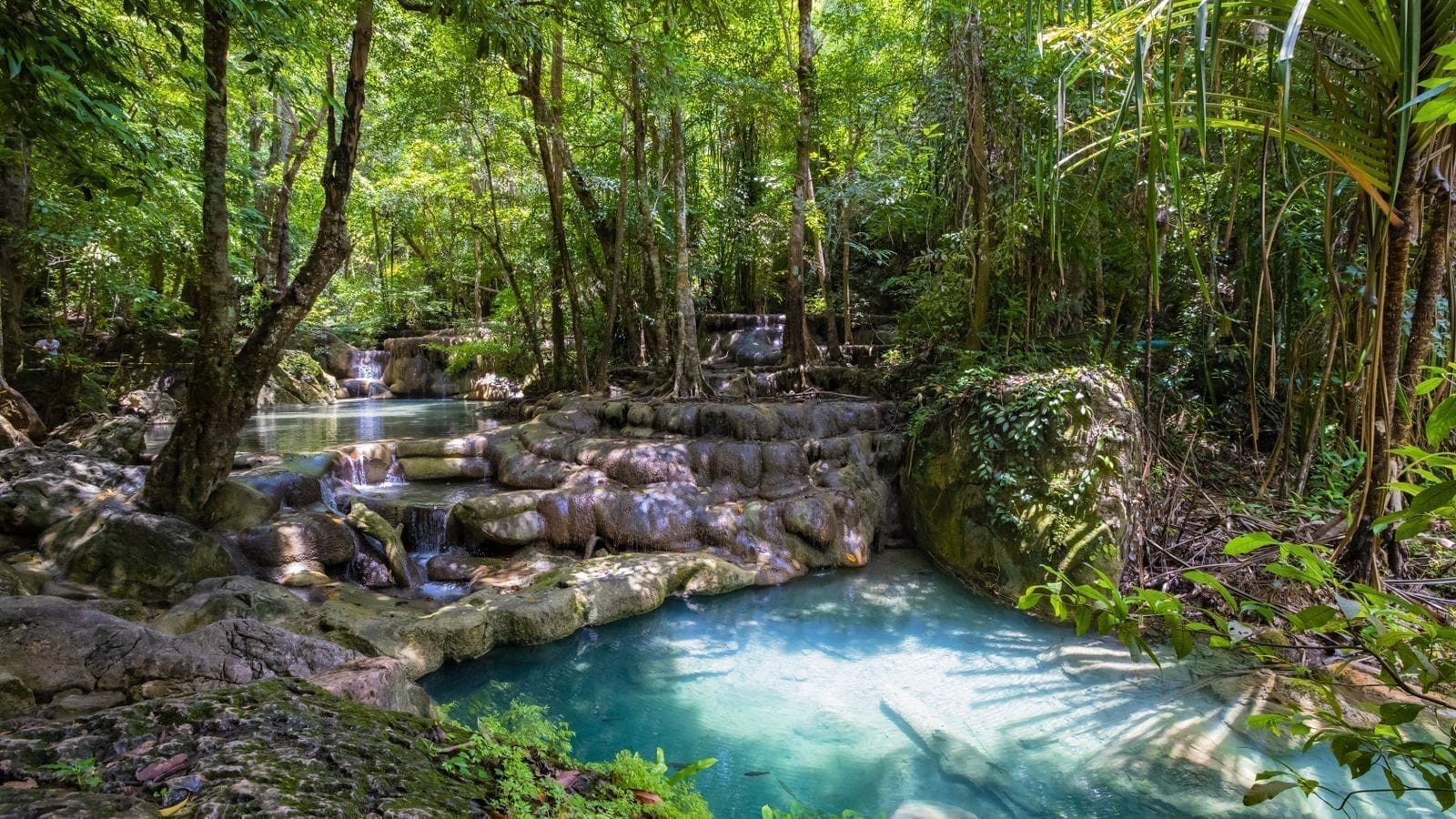
Pacho has four tiers in all. The first one, at the very bottom, is the largest and best-looking — water drops from a broad rock ledge about 60 metres high into a big pool below, and it's where most people take photos and get in the water. The tiers above it have the stream weaving between rocks large and small, with pools collecting here and there if you'd rather find a quieter spot to soak. The water here is clear and cold because it comes straight from the headwater forest of the Budo range.
- First tier — a wide rock face about 60 metres high with a big pool; the busiest swimming spot and an easy walk from the car park
- Upper tiers — water running over boulders with small pools to soak in; you'll need to walk a bit further up the trail
- Flows year-round — there's water to play in all year, though in the rainy season it runs stronger and murkier than in the dry months
Want more out of Narathiwat? Book tours & activities
Booking online ahead on Klook or GetYourGuide is usually cheaper than the gate and skips the queue. Pick only the experiences you actually want — prices and availability are shown live on each site.
The golden leaf — Budo's yan da-oh vine
What sets Pacho apart from other waterfalls is the golden leaf — known to Malay speakers as yan da-oh. It's a climbing vine whose young leaves have a coppery-gold, rainbow-tinged sheen, and in sunlight they glint like real gold, visible from far off. This plant was first discovered anywhere in the world right here in the Budo forest, back in 1988. You'll usually spot it near the front of the waterfall, and if you're lucky enough to visit while the leaves are colouring up, you'll catch the golden vine draped through the green forest.
The golden leaf shows in seasons
The golden leaf isn't gold all the time — it turns its clearest gold while the leaves are still young. If you want to catch it at its best, try asking the park rangers or checking the Budo-Sungai Padi National Park page before you go, so you time it for when the leaves are colouring up.
A short walk through the Budo rainforest
The entrance to the waterfall has a wooden boardwalk and a built path that leads you alongside the stream to the fall — an easy walk, not too steep, fine for kids and adults alike. Along the way there are rest stops with viewpoints to catch your breath and take photos. Both sides of the trail are intact rainforest, shaded by big trees like lumpor and kalor, with rattan and palms covering the forest floor. If you keep quiet, there's a good chance of spotting dusky leaf monkeys hanging in the trees, or forest birds like the orange-bellied flowerpecker flitting past. It's a short hike that gives you the full southern-forest atmosphere without the effort of climbing to a peak.
- Main path — a boardwalk and stream-side trail to the first tier; an easy walk that doesn't take long
- Going up — to reach the upper tiers the trail gets steep and slippery, so wear shoes with good grip and watch for slick rock
- Wildlife you might see — dusky leaf monkeys, orange-bellied flowerpeckers and several other forest birds; come early in the morning and you'll spot them more easily
Swimming at Pacho
The whole point of coming to Pacho is the swimming. The water is clear and cold, straight from the headwater forest, and the big pool under the first tier is where most people get in. The smaller pools on the upper tiers suit anyone who wants to soak quietly and dodge the crowds. The water is at its best from just after the rainy season into early winter — plenty of it, looking good and not yet murky. At the height of the rains it runs strong and turns cloudy, so swim carefully or steer clear of the deep pools.
Swim safely
Swim in the pools where locals are already swimming, and avoid the times when the water is running hard or rain has just come down heavily, since flash floods arrive fast. Keep a close eye on kids — the rock underwater is slippery — and don't drop litter in the water or the forest; carry it back and put it in a bin.
Getting there and what to know before you go
Pacho Waterfall is at Ban Pacho, Bacho subdistrict, Bacho district, about 26 kilometres from Narathiwat town. Drive along Highway 42 (Narathiwat–Pattani) toward Bacho, then turn onto Phiphit Pacho Road for another 9 kilometres or so to reach the park headquarters. The access road is paved and easy to drive. Having your own car or a rental is the most convenient way, since public transport doesn't reach it easily.
- Location — Ban Pacho, Bacho subdistrict, Bacho district, Narathiwat (park HQ on Phiphit Pacho Road)
- Distance — about 26 km from Narathiwat town · about 9 km from Bacho district centre
- Opening hours — generally around 9:00–16:30; best to go from morning to early afternoon
- Entry fee — there's a park entry fee at the National Parks Department rates (foreigners pay more than Thais); check the current rates on site
- Park contact — Budo-Sungai Padi National Park, tel. 0 7355 1676
Where to go next after Pacho
Pacho is in Bacho district — the same district as the 300-year-old Taloh Manoh Mosque (Wadi Al-Husein) — so it's easy to pair them into a single day. Spend the morning swimming and walking the forest at Pacho to freshen up, then stop at the old wooden mosque in the afternoon on the way back toward town. In the evening, head to Narathat Beach to catch the breeze in the city — nature, culture and the sea all in one day.
Taloh Manoh Mosque (300 years old)
An old all-wood mosque in the same Bacho district, built entirely of timber with Thai-Chinese-Malay craftsmanship — an easy stop straight after Pacho.
In townNarathat Beach
A long sandy beach right by town with colourful kolae fishing boats and a cool breeze — save it to round off the day before heading back to your hotel.
Want a full Narathiwat itinerary for the whole trip
See the Narathiwat travel guide →